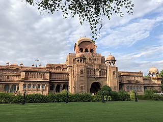
Bikaner is a city in the northwest of the state of Rajasthan, India. It is located 330 kilometres (205 mi) northwest of the state capital, Jaipur. Bikaner city is the administrative headquarters of Bikaner District and Bikaner division.

Datia is the district headquarter of the Datia District in north central Madhya Pradesh,a state of Central India. It is an ancient town, mentioned in the Mahabharata ruled by King Dantavakra. The city is 78 km from Gwalior, 325 km south of New Delhi and 344 km north of Bhopal. About 18 km from Datia is Sonagiri, a sacred Jain hill. Datia is also about 31 km from Jhansi and 52 km from Orchha. The nearest airport is at Gwalior. It was formerly the seat of the eponymous princely state in the British Raj. Datia is situated near Gwalior and on the border with Uttar Pradesh.
Ratangarh is a town and Tehsil of the Churu district in Rajasthan, India. Ratangarh was previously called Kolasar. It is famous for grand havelis (mansions) with frescoes, which is an architectural specialty of the Shekhawati region. Ratangarh is also famous for its handicraft work.

Hanumangarh is a city and municipal council in the Indian state of Rajasthan, situated on the banks of the river Ghaggar also identified as Ancient Sarasvati river, located about 400 km from Delhi. It is the administrative headquarter of Hanumangarh District. The city was once called Bhatner because it was founded by king Bhupat in 255 AD. It remained in the control of the Rajputs of Bhati clan and faced a historic siege by Timur in 1391, during which the Bhati Raput king Dulachand lost the fort for a short time. The fort was later occupied by Rao Jetsa of Bikaner.
Pindwara is a municipality and tehsil located, nearby Sirohi city in Sirohi District in the Indian state of Rajasthan. Pindwara is one of main financial city of Sirohi district after Abu Road. As of 2011, the population of Pindwara is 24,487. It is located 435 km (270 mi) southwest of the state capital, Jaipur, between Aravalli Hills and plains of Marwar region. The city used to be a major area of marble and stone carving in India by long time. It is common belief that if there is any construction of temple work all over the world, it could not complete without involvement of Pindwara artisan. This is proved by this fact that marble carvings of major temples of India like Akshardham temple network, Shri Ram temple Ayodhya are being carried out in the city.

Sri Ganganagar is the northernmost city of the Indian state of Rajasthan, near the international border of India and Pakistan. It is the administrative headquarters of Sri Ganganagar district. It is named after Maharaja Shri Ganga Singh Bahadur, Maharaja of Bikaner. The city is also known as the "Food Basket of Rajasthan".
Taranagar is a city and a municipality in Churu district in the Indian state of Rajasthan, situated at 28° 41'N 75° 3'E, about 120 miles northeast of Bikaner. Taranagar was earlier known as Reni, named for the lady Rinkali who came here to live from Vishalnagar Koyalapatan, currently Foga in Sardarshar (Rajasthan). Reni was the headquarters of the nizamat and the tehsil of the same name in the state of Bikaner in Rajputana. The nizamat consisted of five eastern tehsils of Bhadra, Churu, Nohar, Rajgarh and Reni. In 1948, the town was renamed for King Tara Singh, who ruled it in the mid-18th century.

Churu district is a district of the Indian state of Rajasthan in northern India. It was founded by Banirot Rajputs. Some believe it was a village of jats known as kalera ka bas. Thakur Kushal Singh constructed the Churu fort in 1649 and during the battle of 1871 the area came under dominance of Bikaner State. The town of Churu is the administrative headquarters of the district.

Hanumangarh district is a district in the state of Rajasthan in India. The city of Hanumangarh is the district headquarters and its largest city.
Deshnoke is a City in the Bikaner district of Rajasthan, India.The city is famous for the Karni Mata Temple and was established by Goddess Karni-ji herself who led her followers to this region.
Halol is a city and a municipality (tehsil) in Panchmahal district in the Indian state of Gujarat. Located in western India, it has an average elevation of 499 metres (1637 feet). Halol is a major manufacturing hub of Western India, home to manufacturing facilities of numerous domestic and multinational companies like MG Motor India, Siemens Gamesa, JCB India, Hero Motocorp, Sun Pharma, TOTO India, CEAT Tyres, LM Wind Power, Polycab India, etc.

Merta City is a city and a municipality located, near Nagaur City in Nagaur district in the Indian state of Rajasthan. Merta is also known for its link with Mira Bai, the devotee of Lord Krishna. Mira Mahal Museum houses memories related to Mira Bai's lifetime
Mundi is a city and Tehsil in the Khandwa district of Nimar region the Indian state of Madhya Pradesh. It is situated in North Side of East Nimar District.
Phalodi is a city council in Phalodi district in the Indian state of Rajasthan. It is the headquarters for Phalodi tehsil. Phalodi is also called the "salt city" due to the salt industry in Rin. Phalodi is in the buffer zone of Thar Desert and often subject to extreme temperature conditions due to its arid climate. It holds the record for the highest verified temperature recorded in Rajasthan at 51.0 °C (123.8 °F) on 19 May 2016. It is also the highest temperature ever recorded in India.
Rawatsar is a city, a municipality, and one of the seven tehsils in Hanumangarh district in the Indian state of Rajasthan. It is divided into 35 wards for which elections are held every five years.
Rania is a city and a municipal committee Sirsa district in the Indian state of Haryana. Rania Town is the biggest grain market in Sirsa district.
Khimel is an Indian village situated between Rani and Falna rail station in the Pali District of Rajasthan state. Khimel is divided into two parts: the village and dhani. Khimel is a village in Bali Tehsil in Pali District of Rajasthan, India. It belongs to Jodhpur Division. It is located 60 km towards South from District headquarters Pali. 22 km from Bali. 362 km from State capital Jaipur Khimel Pin code is 306115 and postal head office is Rani Sadar Bazar. Khimel have a small railway station where only local trains halts. Khimel receives 24/7 electricity. This region is called Gorwar and popular language is Marwari. Falna, Bali, Sadri, Sumerpur are the nearby Cities to Khimel.
Deengli is a village in Rajgarh, Churu, Rajasthan, India. As per 2011 Census of India, the village has population of 2197 of which 1144 are males while 1053 are females. It comes under ‘’’Sulkhnia chhotta’’’ Panchayath. It belongs to Bikaner Division. As per constitution of India and Panchyati Raaj Act, Deengli village is administrated by Sarpanch who is elected representative of village. It is located 65 km towards East from District headquarters Churu. 230 km from State capital Jaipur. The most famous place in Deengli is Net Dada JI temple.
Jamsar is a small village in Bikaner, Rajasthan, India. There were 467 households in the village in 2011. Located in a desert environment, the nearest city is Bikaner.
Ramlal Siyag, was an Indian contemporary saint who is known for spreading Siddha Yoga, a chanting and meditation based spiritual practice, based on the yoga as codified by sage Patanjali in a treatise called 'Yoga Sutra'.

