Idikarai is a panchayat town in Coimbatore district in the Indian state of Tamil Nadu. It is situated at the banks of Kousika River. The place is easily accessible by Road through public transportation.
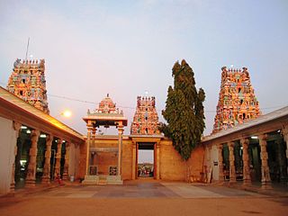
Kodumudi is a panchayat town and taluk headquarters of Kodumudi taluk in Erode district at state of Tamil Nadu, India. Kodumudi has an average elevation of 144 metres (472 feet). Also Kodumudi is an tourism spot. The holy Kaveri river and Magudeswarar temple in Kodumudi attracts thousands of pilgrims daily across South India.
Kolathupalayam is a panchayat town in Dharapuram taluk of Tirupur District in the Indian state of Tamil Nadu. Kolathupalayam Located 5km From Dharapuram.
Kurumbalur is a panchayat town in Perambalur district in the Indian state of Tamil Nadu.
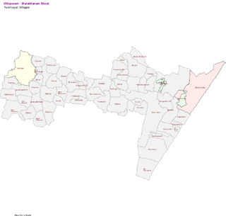
Marakkanam is a coastal panchayat town & Taluk in Viluppuram district in the Indian state of Tamil Nadu. It is well connected to the state capital Chennai and the nearby union territory of Puducherry by the East Coast Road. To the west, Marakkanam is connected to the town of Tindivanam by the SH-134. Marakkanam is situated on the declared National Waterways NW-4. On materialisation of National Waterways NW-4, Marakkanam will be connected to two states Andhra Pradesh (Kakinada) and Puducherry through north and south of Buckingham Canal.
Minjur is a town located in the outskirts of North Chennai, India. It is located in the Thiruvallur district in the Indian state of Tamil Nadu. Minjur is called 'Vada Kanchi' meaning North Kanchipuram. The town has two famous temples for Shiva and Vishnu, similar to Kanchipuram. The neighbourhood is served by Minjur railway station of the Chennai Suburban Railway Network.
Narasimhanaickenpalayam is a part of Coimbatore city. It is about 14 km from Coimbatore city junction in the northern direction. Narasimhanaickenpalayam is on the stretch of National Highway NH 67 Extn (NH-181) Mettupalayam Road, one of the arterial roads of Coimbatore city. Neighbouring places are Thudiyalur, NGGO Colony, and Periyanaickenpalayam
Nilakkottai is a town in the Dindigul district of the Indian state of Tamil Nadu. The town was established in 1958, as 1st Grade Town Panchayat. In 1970, it was changed to Selection Grade. The Town Panchayat has been under the municipal act since 1996. In 2004, it was called Special Village Panchayat, and in 2006, Selection Grade Town Panchayat.
Periya Negamam is a panchayat town in Coimbatore district in the southern Indian State of Tamil Nadu. It comes under Pollachi Taluk and pollachi Assembly constituency. Negamam used to be a popular small town serving the commercial and transport needs of many small villages around it until 1980s. With the arrival of frequent city buses to Pollachi and Udumalpet as transportation mode, growth of Negamam remained stunted. Weekly market on Tuesday used to be a big crowd puller.
Pudupalayam is a panchayat town in Chengam taluk of Tiruvanamalai district in the Indian state of Tamil Nadu. Its pincode number is 606 705.It is well connected with Tiruvannamalai and Bangalore. This is at Bangalore Road at 33 km away from the famous Annamalaiyar Temple located in Thiruvannamalai.
Sarcarsamakulam, also known as Kovilpalayam, is a western suburb in Coimbatore in the Indian state of Tamil Nadu. This town is located 17 kilometers from Coimbatore Junction and 12 kilometers from Coimbatore International Airport, Tamil Nadu, India, on the Sathyamangalam Road. Neighbouring places are Saravanampatti, Kalapatti, Vilankurichi
Sirugamani is a panchayat town in Srirangam taluk Tiruchirappalli district in the Indian state of Tamil Nadu. It's situated on the banks of river cauvery, just a few miles away from Trichy on the way towards Karur. To be specific, it is in between Perugamani and Kaavalkara Palayam near Pettavaaithalai.
Thevaram is a town in Theni district in the Indian state of Tamil Nadu. Thevaram is located in Tamil Nadu near on border of Kerala at the Eastern side foot-hill of the Western Ghats. It is connected with State Highway SH100.

Udayarpalayam is a panchayat town in the Ariyalur district of the Indian state of Tamil Nadu, near Jayankondam.

Vadavalli is a neighborhood in Coimbatore in the Indian state of Tamil Nadu. It is located on the Marudamalai Road and has been under the jurisdiction of the Coimbatore City Municipal Corporation limits since 2007. Located at the foothills of the Western Ghats, Vadavalli has a pleasant climate all through the year and has good ground water resources.
Jafarabad is a town and nagar panchayat in Jaunpur district in the Indian state of Uttar Pradesh.
Mettupalayam is a panchayat town in Tiruchirappalli district in the Indian state of Tamil Nadu.it's near to kolli hills.
Sivagiri is a panchayat town and a tourist place in Tenkasi district in the Indian state of Tamil Nadu. Sivagiri is located at a distance of 50 km north to Tenkasi, 20 km south to Rajapalayam, 95 km north-west to Tirunelveli, 95 km south to Madurai, 540 km south to Bangalore, 150 km north to Thiruvananthapuram and 580 km south to the state capital Chennai.
PeriyaKuravan Palayam village, Nagadevam Palayam post, also known as Velliankattu Pudur, is a small village of less than 150 inhabitants, situated in the Gobi taluk, Erode district in Tamil Nadu, India. It has one government library. The nearest village is Ayyam Pudhur. It is situated near to Gobichettipalayam at about 10 km. Agriculture is the primary occupation, with coconuts, rice, Turmeric and sugarcane being the main crops grown.

 India
India 