
Palchan is a village in the Kullu district in the state of Himachal Pradesh, India. It has a population of 1,241 according to 2011 census. [1] it is close to tourist places of Manali, Solang and Rohtang pass.
Palchan is a village in the Kullu district in the state of Himachal Pradesh, India. It has a population of 1,241 according to 2011 census. [1] it is close to tourist places of Manali, Solang and Rohtang pass.

Himachal Pradesh is a state in the northern part of India. Situated in the Western Himalayas, it is one of the thirteen mountain states and is characterized by an extreme landscape featuring several peaks and extensive river systems. Himachal Pradesh is the northernmost state of India and shares borders with the union territories of Jammu and Kashmir and Ladakh to the north, and the states of Punjab to the west, Haryana to the southwest, Uttarakhand to the southeast and a very narrow border with Uttar Pradesh to the south. The state also shares an international border to the east with the Tibet Autonomous Region in China. Himachal Pradesh is also known as Dev Bhoomi, meaning 'Land of Gods' and Veer Bhoomi which means 'Land of the Brave'.
Kullu is a district in Himachal Pradesh, India. It borders Rampur district to the south, Mandi and Kangra districts to the west, and the Lahaul and Spiti district to the north and east. The largest valley in this mountainous district is the Kullu Valley. The Kullu valley follows the course of the Beas River, and ranges from an elevation of 833m above sea level at Aut to 3330m above sea level at the Atal Tunnel South Portal, below the Rohtang Pass. The town of Kullu, or simply Kullu, located on the right side of the Beas River, serves as the administrative headquarters of the Kullu district. The Kullu district also incorporates several riverine tributary valleys of the Beas, including those of the Parvati, Sainj, and Tirthan rivers, and thus some regions somewhat distant from the Kullu valley. The economy of the district relies mainly on horticulture, agriculture, tourism, and traditional handicrafts.

Mandi district is one of the central districts of Himachal Pradesh state in northern India. The town of Mandi is the headquarters of the district.

Manali is a town, near Kullu town in Kullu district in the Indian state of Himachal Pradesh. It is situated in the northern end of the Kullu Valley, formed by the Beas River. The town is located in the Kullu district, approximately 270 kilometres (170 mi) north of the state capital of Shimla and 544 kilometres (338 mi) northeast of the national capital of New Delhi. With a population of 8,096 people recorded in the 2011 Indian census Manali is the beginning of an ancient trade route through Lahaul (H.P) and Ladakh, over the Karakoram Pass and onto Yarkand and Hotan in the Tarim Basin of China. Manali is a popular tourist destination in India and serves as the gateway to the Lahaul and Spiti district as well as the city of Leh in Ladakh.

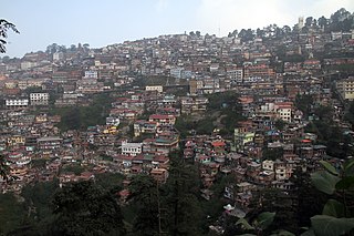
Kullu is a municipal council town that serves as the administrative headquarters of the Kullu district of the Indian state of Himachal Pradesh. It is located on the banks of the Beas River in the Kullu Valley about 10 kilometres (6.2 mi) north of the airport at Bhuntar, Kullu.
Shimla is a district in the state of Himachal Pradesh in northern India. Its headquarters is the state capital of Shimla. Neighbouring districts are Mandi and Kullu in the north, Kinnaur in the east, Uttarakhand in the southeast, Solan to the southwest and Sirmaur in the south. The elevation of the district ranges from 987 metres (3,238 ft) to 4,500 metres (14,764 ft).
Nurpur is a city and a municipal council in Kangra district in the Indian state of Himachal Pradesh. It was formerly part of the Nurpur State since the 11th century AD. The capital of the state was at Pathankot formerly known as Paithan, now in Punjab.It got its name from wife of Mughal emperor Jahangir, Nur Jahan, when they visited Kangra (Nagarkot) after Jahangir's successful conquest of the Kangra Fort.
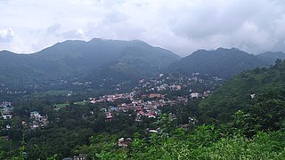
Sundar Nagar is a town and a municipal council in Mandi district in the Indian state of Himachal Pradesh. Formerly it was a princely state, known as Suket.
Raison is a stopover which has vast camping grounds maintained by Himachal Pradesh Tourism.

The Leh–Manali Highway is a 428 km (266 mi) long highway in northernmost India connecting Leh, the capital of the Union Territory of Ladakh, to Manali in the state of Himachal Pradesh. It connects the Kullu Valley of the upper Beas river to the Chandra and Bhaga river valleys of Lahaul via the Atal tunnel in Himachal Pradesh, then crosses over a series of high Himalayan passes into the Indus river valley in Ladakh. It is usually open for about six months in a year from the first week of May, when the snow is cleared from the highway, to October, when snowfall again blocks the high passes on the highway. Before the construction of the Atal tunnel, the highway used to remain closed beyond the Rohtang Pass during winter. With the completion of proposed Shingo La Tunnel on an alternate route through Zanskar valley, targeted to be completed by 2025, the whole Leh-Manali route will become an all-weather road.

The dark-breasted rosefinch is a species of true finch in the monotypic genus Procarduelis. It is found in Bhutan, China, India, Laos, Myanmar, Nepal, Pakistan, Thailand, and Vietnam. Its natural habitats are boreal forests and subtropical or tropical high-altitude shrubland.

The streaked laughingthrush is a species of bird in the family Leiothrichidae. It is commonly found in the northern regions of the Indian subcontinent and some adjoining areas, ranging across Afghanistan, Bhutan, India, Nepal, Pakistan, Russia, and Tajikistan.

The grey bush chat is a species of passerine bird in the family Muscicapidae. It is found in the Himalayas, southern China, Taiwan, Nepal and mainland Southeast Asia.

Sissu is a small town in the Lahaul valley of Himachal Pradesh in India. It is around 40 km from Manali and located on the right bank of Chandra river. It is located at 32°29′0″N77°7′0″E. It is 3,120 m above sea level. It is 14 km from Koksar to the south-east and 11 km. west to Gondhla.
Tourism in Himachal Pradesh relates to tourism in the Indian state of Himachal Pradesh. This is popularly renowned for its Himalayan landscapes and popular hill-stations. Many outdoor activities such as rock climbing, mountain biking, paragliding, ice-skating, trekking, rafting, and heli-skiing are popular tourist attractions in Himachal Pradesh.

Nirmand is a village located in Kullu district, of the Indian state of Himachal Pradesh. It is one of the largest villages in Himachal Pradesh and serves as the headquarters of Nirmand Tehsil and Nirmand developmental block of Kullu district.
Inderkilla National Park is a national park in Himachal Pradesh, India established in 2010. It covers an area of about 104 square kilometres (40 sq mi). The national park is located in the Kullu district and 46.1 kilometers away from the Kullu Manali Airport.

Tinno is a village in Lahaul and Spiti district of Himachal Pradesh. It is around 14 km from Keylong, which is district headquarters. The village is along Manali-Leh Highway on left bank of Bhaga river, which originates from Suraj Taal lake. It has a total of 29 families residing in the village. The Tinno village has a population of 125, of which 59 are males while 66 are females as per Population Census 2011. In 2011, the literacy rate of Tinno village was 82.35%. In Tinno male literacy stands at 87.72% while female literacy rate was 77.42%. As per constitution of India and Panchyati Raaj Act, Tinno village is administrated by a Sarpanch who is elected representative of village.
Manali Assembly constituency is one of the 68 constituencies in the Himachal Pradesh Legislative Assembly of Himachal Pradesh a northern state of India. Manali is also part of Mandi Lok Sabha constituency.
Hanuman Tibba is the highest mountain peak in Kangra district and lies on Dhauladhar Range in Himachal Pradesh, with an altitude of 5,982 metres (19,626 ft) above sea level. It lies to the Northwest of Manali and to the East of Solang. To the north of Hamuman Tibba, lies the Taintuka Pass and to the south lies Manali Pass. These Passes form the district boundary between the kangra District and Kullu District. It is a well known local peak, partly due to it resembling a steep pyramid, with its noted feature of steep vertical rise from its base camp site. Its west face has been a recent site to many attempts to climb through the “west spur”, a steep, technical, sustained rocky feature often exposed to winds and gnarly ice flutings. The Diretissima through this face and the north face- overall, is still unclimbed. In a noted recent attempt by the Alpine Club of the Greater Himalayas, 4 alpinists tried climbing through this very spur, but were defeated by rotten ice conditions, high at 5,720 m (18,770 ft).
Coordinates: 32°18′36″N77°10′32″E / 32.3099139°N 77.17551°E
| | This Himachal Pradesh location article is a stub. You can help Wikipedia by expanding it. |