Paljane

Last updated
Paljane
Village
CountryFlag of Serbia.svg  Serbia
District Pomoravlje District
Municipality Ćuprija
Population (2002)
  Total 535
Time zone CET (UTC+1)
  Summer (DST) CEST (UTC+2)

Paljane is a village in the municipality of Ćuprija, Serbia. According to the 2002 census, the village has a population of 535 people. [1]

Village Small clustered human settlement smaller than a town

A village is a clustered human settlement or community, larger than a hamlet but smaller than a town, with a population ranging from a few hundred to a few thousand. Though villages are often located in rural areas, the term urban village is also applied to certain urban neighborhoods. Villages are normally permanent, with fixed dwellings; however, transient villages can occur. Further, the dwellings of a village are fairly close to one another, not scattered broadly over the landscape, as a dispersed settlement.
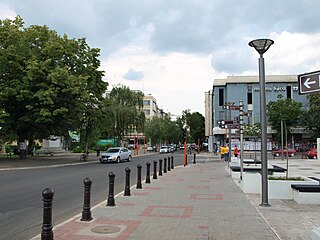
Ćuprija Town and municipality in Šumadija and Western Serbia, Serbia

Ćuprija is a town and municipality located in the Pomoravlje District of central Serbia. The population of the town is 19,380, while the municipality has 30,645 inhabitants.

Serbia Republic in Southeastern Europe

Serbia, officially the Republic of Serbia, is a country situated at the crossroads of Central and Southeast Europe in the southern Pannonian Plain and the central Balkans. The sovereign state borders Hungary to the north, Romania to the northeast, Bulgaria to the southeast, North Macedonia to the south, Croatia and Bosnia and Herzegovina to the west, and Montenegro to the southwest. The country claims a border with Albania through the disputed territory of Kosovo. Serbia's population is about seven million, most of whom are Orthodox Christians. Its capital, Belgrade, ranks among the oldest and largest citiеs in southeastern Europe.

Related Research Articles

Bosnian-Podrinje Canton Goražde Canton in Federation of Bosnia and Herzegovina, Bosnia and Herzegovina

The Bosnian-Podrinje Canton Goražde is one of ten cantons of the Federation of Bosnia and Herzegovina, an entity in Bosnia and Herzegovina.

Suwayq Town in Al Batinah Region, Oman

Al Suwaiq is a coastal town in the region Al Bāţinah, in northeastern Oman. It is located at around 23°50′58″N57°26′19″E. The name of the town refers in Arabic Language to Market, It’s named by this name because it located in the central of AL Batina Region and attracted the people lived in the mounts and also people lived by the region’s coast to buy and sell goods.

Harveng is a village near the Belgian town of Mons in the province of Hainaut.

Verin Sasnashen Place in Aragatsotn, Armenia

Verin Sasnashen ; formerly known as Verin Karakoymaz and Verin Sasunashen, is a village in the Aragatsotn Province of Armenia.

Marcinkowo is a village in the administrative district of Gmina Mogilno, within Mogilno County, Kuyavian-Pomeranian Voivodeship, in north-central Poland.

Chojewo-Kolonia is a settlement in the administrative district of Gmina Brańsk, within Bielsk County, Podlaskie Voivodeship, in north-eastern Poland.

Ucarlı Municipality in Kurdamir, Azerbaijan

Ucarlı is a village and municipality in the Kurdamir Rayon of Azerbaijan.

Yanıq Ələz Place in Siazan, Azerbaijan

Yanıq Ələz is a village in the Siazan Rayon of Azerbaijan. The village forms part of the municipality of Yuxarı Ələz.

Bobin is a village in the administrative district of Gmina Proszowice, within Proszowice County, Lesser Poland Voivodeship, in southern Poland.

Łękawa is a village in the administrative district of Gmina Kazimierza Wielka, within Kazimierza County, Świętokrzyskie Voivodeship, in south-central Poland.

Koczwara Village in Świętokrzyskie, Poland

For the composer of the same name see Frantisek Kotzwara.

Rożniaty Village in Subcarpathian, Poland

Rożniaty is a village in the administrative district of Gmina Padew Narodowa, within Mielec County, Subcarpathian Voivodeship, in south-eastern Poland. It lies approximately 5 kilometres (3 mi) west of Padew Narodowa, 18 km (11 mi) north of Mielec, and 61 km (38 mi) north-west of the regional capital Rzeszów.

Grabów is a village in the administrative district of Gmina Toszek, within Gliwice County, Silesian Voivodeship, in southern Poland.

Mołstówko Village in West Pomeranian, Poland

Mołstówko is a village in the administrative district of Gmina Brojce, within Gryfice County, West Pomeranian Voivodeship, in north-western Poland. It lies approximately 4 kilometres (2 mi) north of Brojce, 14 km (9 mi) north-east of Gryfice, and 82 km (51 mi) north-east of the regional capital Szczecin.

Chłopy Village in West Pomeranian, Poland

Chłopy is a village in the administrative district of Gmina Mielno, within Koszalin County, West Pomeranian Voivodeship, in north-western Poland. It lies approximately 15 kilometres (9 mi) north-west of Koszalin and 131 km (81 mi) north-east of the regional capital Szczecin.

Zezezino is a rural locality in Idrinsky District of Krasnoyarsk Krai, Russia.

Cummertrees railway station

Cummertrees railway station was a railway station in Dumfries and Galloway south of Dumfries, serving the village of Cummertrees. The village lies some 3 miles (4.8 km) west of Annan and 12 miles (19 km) south of Lockerbie.

Chà Tở is a commune () and village of the Mường Chà District of Điện Biên Province, northwestern Vietnam.

Kladurovo Village in Braničevo District, Serbia

Kladurovo is a village situated in Petrovac na Mlavi municipality in Serbia.

Lukovo (Svrljig) Village in Nišava District, Serbia

Lukovo (Svrljig) is a village in the municipality of Svrljig, Serbia. According to the 2002 census, the village has a population of 277 people.

References

  1. Popis stanovništva, domaćinstava i Stanova 2002. Knjiga 1: Nacionalna ili etnička pripadnost po naseljima. Republika Srbija, Republički zavod za statistiku Beograd 2003. ISBN   86-84433-00-9

Coordinates: 43°59′10″N21°26′19″E / 43.98611°N 21.43861°E / 43.98611; 21.43861

Geographic coordinate system Coordinate system

A geographic coordinate system is a coordinate system that enables every location on Earth to be specified by a set of numbers, letters or symbols. The coordinates are often chosen such that one of the numbers represents a vertical position and two or three of the numbers represent a horizontal position; alternatively, a geographic position may be expressed in a combined three-dimensional Cartesian vector. A common choice of coordinates is latitude, longitude and elevation. To specify a location on a plane requires a map projection.