
Miryalaguda is a city in Nalgonda district of the Indiastate of Telangana. Government of India announced Miryalaguda to be developed under the Atal Mission for Rejuvenation and Urban Transformation (AMRUT) scheme. Miryalaguda has Grabbed an award for Urban reforms in AMRUT Scheme from Government of india

Pamidi is a village in Anantapur district of the Indian state of Andhra Pradesh. It is the mandal headquarters of Pamidi mandal in Anantapur revenue division.
Punganur is a town in Chittoor district of the Indian state of Andhra Pradesh. It is the mandal headquarters of Punganur mandal.
Venkatagiri is a town in Nellore district of the Indian state of Andhra Pradesh. It is a municipality and mandals headquarters of Venkatagiri mandal. Venkatagiri's old name is "Kali Mili". It is famous for its Handloom Cotton Sarees. Venkatagiri is a place for history and handlooms. It was part of a small kingdom that was integrated into the Indian Republic.
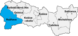
Hrušov is a village and municipality in the Rožňava District in the Košice Region of middle-eastern Slovakia.
Bantumilli is a village in Krishna district of the Indian state of Andhra Pradesh. It is the mandal headquarters of Bantumilli mandal of Machilipatnam revenue division.

Rupsa is an Upazila of Khulna District in the Division of Khulna, Bangladesh.
Kamalapuram is a village in Kadapa district of the Indian state of Andhra Pradesh. It is located in Kamalapuram mandal of Kadapa revenue division.
Ramagiri is a village in Anantapur district of the Indian state of Andhra Pradesh. It is the mandal headquarters of Ramagiri mandal in Dharmavaram revenue division.
Gambhiraopet is a village in Gambhiraopet mandal of Rajanna Sircilla district in the state of Telangana in India.

Nienaszów is a village in the administrative district of Gmina Nowy Żmigród, within Jasło County, Subcarpathian Voivodeship, in south-eastern Poland. It lies approximately 5 kilometres (3 mi) north-east of Nowy Żmigród, 16 km (10 mi) south-east of Jasło, and 54 km (34 mi) south-west of the regional capital Rzeszów.
Lebiedzie is a village in the administrative district of Gmina Sterdyń, within Sokołów County, Masovian Voivodeship, in east-central Poland. It lies approximately 3 kilometres (2 mi) north-east of Sterdyń, 20 km (12 mi) north of Sokołów Podlaski, and 98 km (61 mi) north-east of Warsaw.
Kaczka is a village in the administrative district of Gmina Goworowo, within Ostrołęka County, Masovian Voivodeship, in east-central Poland. It lies approximately 6 kilometres (4 mi) south of Goworowo, 25 km (16 mi) south of Ostrołęka, and 81 km (50 mi) north-east of Warsaw.
Osiek is a village in the administrative district of Gmina Strzelce Opolskie, within Strzelce County, Opole Voivodeship, in south-western Poland. It lies approximately 10 kilometres (6 mi) north of Strzelce Opolskie and 28 km (17 mi) east of the regional capital Opole.
Gozd is a village in the administrative district of Gmina Bobolice, within Koszalin County, West Pomeranian Voivodeship, in north-western Poland. It lies approximately 6 kilometres (4 mi) north of Bobolice, 34 km (21 mi) south-east of Koszalin, and 147 km (91 mi) north-east of the regional capital Szczecin.
Łozice is a village in the administrative district of Gmina Bobolice, within Koszalin County, West Pomeranian Voivodeship, in north-western Poland. It lies approximately 6 kilometres (4 mi) south of Bobolice, 41 km (25 mi) south-east of Koszalin, and 143 km (89 mi) east of the regional capital Szczecin.
Cetuń is a village in the administrative district of Gmina Polanów, within Koszalin County, West Pomeranian Voivodeship, in north-western Poland. It lies approximately 8 kilometres (5 mi) west of Polanów (Pollnow), 29 km (18 mi) south-east of Koszalin (Köslin), and 152 km (94 mi) north-east of the regional capital Szczecin (Stettin).

Kunavaram is a village in East Godavari district, Andhra Pradesh. Kunavaram was a part of Khammam district of then newly formed Telangana until the transfer of 7 mandals including it to then newly formed Andhra Pradesh.
Cerro Viejo is a corregimiento in Tolé District, Chiriquí Province, Panama. It has a land area of 59.5 square kilometres (23.0 sq mi) and had a population of 1,768 as of 2010, giving it a population density of 29.7 inhabitants per square kilometre (77/sq mi). Its population as of 1990 was 2,923; its population as of 2000 was 1,709.
Lakhapadar is a village and former non-salute princely state on Saurashtra peninsula in Gujarat, western India. About Lakhapadar


