
The Orinoco Delta is a vast river delta of the Orinoco River, located in eastern Venezuela.

The Catatumbo River is a river rising in northern Colombia, flowing into Lake Maracaibo in Venezuela. The Catatumbo River is approximately 340 kilometres (210 mi) long. It forms a part of the international boundary between the two countries. The river's name means "House of Thunder" in the language of the Bari people.

The Aroa River is a river in northwestern Venezuela. It runs parallel and west of the Yaracuy River. The Aroa River empties into the Caribbean Sea.
The Motatán River is a river of Venezuela. It drains into Lake Maracaibo.
The Escalante River is a river of Venezuela. It drains into Lake Maracaibo.
The Apón River is a river of Venezuela. It drains into Lake Maracaibo.

The Tocuyo River is a river of Venezuela. It drains into the Caribbean Sea.
Hueque River is a river of northern Venezuela. It flows into the Caribbean Sea.

The Espinal (NT0801) is an ecoregion of dry, thorny forest, savanna and steppe in Argentina. It has been extensively modified by large scale cattle ranching, but remnants of the original flora remain. It is threatened by the advance of the irrigation-based agricultural frontier.

The Marañón dry forests (NT0223) is an ecoregion in northern Peru. It covers the lower valley of the Marañón River and its tributaries along the eastern edge of the Andes. It has a dry climate due to rain shadow from mountains further east. The habitat has long been modified by farming, ranching and logging and is now threatened by construction of hydroelectric and irrigation dams.

The Cordillera de Merida páramo (NT1004) is an ecoregion containing páramo vegetation above the treeline in the Andes mountain range of Venezuela. The isolated habitat has many endemic species. It is relatively stable and intact.
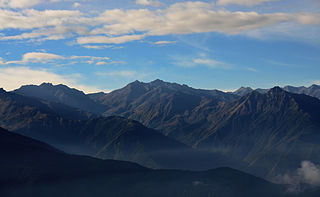
The Venezuelan Andes montane forests (NT0175) is an ecoregion in the northern arm of the Andes in Venezuela. It contains montane and cloud forests, reaching up to the high-level Cordillera de Merida páramo high moor ecoregion. The forests are home to many endemic species of flora and fauna. Their lower levels are threatened by migrant farmers, who clear patches of forest to grow crops, then move on.

The Tamá Massif is a group of mountains on the border between Colombia and Venezuela to the south of Lake Maracaibo. It contains evergreen rainforest and cloud forest at the lower levels, and páramos at the highest levels.

The Apure–Villavicencio dry forests (NT0201) is an ecoregion in Venezuela and Colombia to the east of the eastern cordillera of the Andes. The ecoregion covers the transition zone between montane forests in the Andes and the llanos, or lowland grasslands. It has been severely degraded by deforestation, farming and ranching. The remnants are poorly protected.

The Cordillera Oriental montane forests (NT0118) is an ecoregion in Venezuela and Colombia along the east slopes of the eastern cordillera of the Andes. The extensive region of submontane and montane forests includes distinctive flora and fauna in the north, center and southern sections. The ecoregion is home to numerous endemic species of fauna. Despite extensive changes due to logging, farming and ranching, large areas of the original habitat remain intact, and the ecoregion has rich biodiversity.

The Catatumbo moist forests (NT0108) is an ecoregion in Venezuela and Colombia to the west and east of Lake Maracaibo. It includes four regions of moist forest on slightly higher ground than the dry forest and mangroves that surround the lake. The forest has unique flora related to the flora of the Amazon basin. It is badly degraded due to farming, livestock grazing and oil exploration.

The Táchira Depression is a saddle of land connecting the Lake Maracaibo basin to the Orinoco basin in the state of Táchira, Venezuela. It forms a break in the eastern Andes, separating the Tamá Massif to the west from the Cordillera de Mérida to the east. The depression has been thought to present a barrier to the movement of species between the Colombian and Venezuelan Andes, but this effect may have been relatively low during the recent ice ages. The mountains of the region have potential for coffee farming and hydroelectric power generation, while the lower levels are suitable for farming.
The Maracaibo dry forests (NT0222) is an ecoregion in Venezuela around Lake Maracaibo. It contains the country's main oil fields. The habitat is criss-crossed by roads and is severely degraded by farming and livestock grazing.

The La Costa xeric shrublands (NT1309) is an ecoregion in Venezuela that stretches along the Caribbean coast. The dry scrub and savanna has been subject to modification since the 16th century by European colonists who replaced it by a patchwork of farm fields and pasturage. Little of the original habitat remains.

The Lara–Falcón dry forests (NT0219) is an ecoregion that extends inland from the Caribbean coast of northwestern Venezuela. To the east and west the dry forests of the hilly region transition into xeric shrublands. There are several endemic bird species including the vulnerable yellow-shouldered amazon, in demand as a pet. There are few protected areas. Despite the relatively infertile soils, a large part of the ecoregion has been converted to farmland or pasturage.
