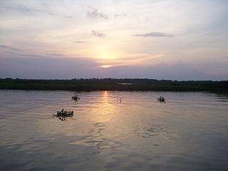
The Maracaibo dry forests (NT0222) is an ecoregion in Venezuela around Lake Maracaibo. It contains the country's main oil fields. The habitat is criss-crossed by roads and is severely degraded by farming and livestock grazing.
The Maracaibo dry forests surround Lake Maracaibo in northwest Venezuela. The ecoregion has an area of 4,506,579 hectares (11,136,000 acres).[1] Most of the ecoregion is in Zulia state, with some in Trujillo state.[2]
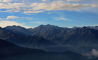
The Maracaibo dry forests are in the coluvio-alluvial coastal plains around Lake Maracaibo, bordering the Serranía del Perijá to the west, the Cordillera de Mérida to the south and the Sierra de Baragua to the northeast. The terrain of the ecoregion is flat and gives way to transitional moist forests higher in the mountains. Elevations are 0 to 500 metres (0 to 1,640ft) above sea level. Several rivers flow from the surrounding mountains through the ecoregion to Lake Maracaibo. They include the Palmar, Negro, Lora and Catatumbo rivers from the Serranía del Perijá, the Escalante River from the Venezuelan Andes and the Motatán, Misoa and Pachango rivers in the east of the basin.[2]
Climate
Annual temperatures are from 16 to 26°C (61 to 79°F). Less than 1,000 millimetres (39in) of rain falls annually, with pronounced dry and wet seasons.[2] At a sample location at coordinates 10°15′N71°15′W / 10.25°N 71.25°W / 10.25; -71.25 the Köppen climate classification is "Aw": equatorial, winter dry.[4] At this location the temperature is fairly constant throughout the year, ranging from an average mean of 27°C (81°F) in January to 28.5°C (83.3°F) in August. Total yearly rainfall is around 840 millimetres (33in). Rainfall varies from 5.3 millimetres (0.21in) in January to 113.2 millimetres (4.46in) in May, drops to 68 millimetres (2.7in) in July then rises again to 166.1 millimetres (6.54in) in October.[4]
The World Wildlife Fund gives the ecoregion the status of "Critical/Endangered". As with other neotropical dry forests the habitat has been severely damaged by livestock and agriculture and is at risk of complete destruction. The ecoregion is cut up by a large network of roads, including the Pan-American Highway. It contains the Bolivar Coastal Field on the northeastern shore of the lake. The oil fields in and around the lake produce most of Venezuela's oil. Some of the rivers are polluted with pesticides and fertilizers[2]
WildFinder, WWF: World Wildlife Fund, retrieved 2017-04-17
Related Research Articles
The Catatumbo River is a river rising in northern Colombia, flowing into Lake Maracaibo in Venezuela. The Catatumbo River is approximately 340 kilometres (210 mi) long. It forms a part of the international boundary between the two countries.
The Motatán River is a river of Venezuela. It drains into Lake Maracaibo.
The Escalante River is a river of Venezuela. It drains into Lake Maracaibo.
The Apón River is a river of Venezuela. It drains into Lake Maracaibo.
The Palmar River is a river of Venezuela. It drains into Lake Maracaibo.
The Ciénagas del Catatumbo National Park Also Catatumbo Marshes National Park or Ciénagas de Juan Manuel National Park Is a protected area. of Venezuela.
The Amazon–Orinoco–Southern Caribbean mangroves (NT1401) is an ecoregion along the coasts of Colombia, Venezuela, Guyana, Suriname, French Guiana and Brazil.
The Santa Marta páramo (NT1007) is an ecoregion containing páramo vegetation above the treeline in the Sierra Nevada de Santa Marta mountain range on the Caribbean coast of Colombia. The isolated position of the range has allowed unique species to evolve. Some are related to those found in Central America and the Caribbean coastal areas, and some to species from the Andes. The habitat is relatively stable, but has been drastically changed from the original by long-term human activity.
The Venezuelan Andes montane forests (NT0175) is an ecoregion in the northern arm of the Andes in Venezuela. It contains montane and cloud forests, reaching up to the high-level Cordillera de Merida páramo high moor ecoregion. The forests are home to many endemic species of flora and fauna. Their lower levels are threatened by migrant farmers, who clear patches of forest to grow crops, then move on.
The Apure–Villavicencio dry forests (NT0201) is an ecoregion in Venezuela and Colombia to the east of the eastern cordillera of the Andes. The ecoregion covers the transition zone between montane forests in the Andes and the llanos, or lowland grasslands. It has been severely degraded by deforestation, farming and ranching. The remnants are poorly protected.
The Cordillera Oriental montane forests (NT0118) is an ecoregion in Venezuela and Colombia along the east slopes of the eastern cordillera of the Andes. The extensive region of submontane and montane forests includes distinctive flora and fauna in the north, center and southern sections. The ecoregion is home to numerous endemic species of fauna. Despite extensive changes due to logging, farming and ranching, large areas of the original habitat remain intact, and the ecoregion has rich biodiversity.
The Catatumbo moist forests (NT0108) is an ecoregion in Venezuela and Colombia to the west and east of Lake Maracaibo. It includes four regions of moist forest on slightly higher ground than the dry forest and mangroves that surround the lake. The forest has unique flora related to the flora of the Amazon basin. It is badly degraded due to farming, livestock grazing and oil exploration.
The Paraguana xeric scrub (NT1313) is an ecoregion in Venezuela to the north and east of Lake Maracaibo and along the coast of Aruba, Bonaire, and Curaçao. The region holds flora and fauna adapted to the very dry conditions of the coastal dunes and inland areas of bush, scrub, briars and cacti. There are several endangered species of animals and birds. Efforts at protecting the environment have been ineffective. Most of the original trees have been cut down, dunes are being destabilized by loss of vegetation, scrub is replaced by farmland and vegetation is destroyed by grazing goats.
The La Costa xeric shrublands (NT1309) is an ecoregion in Venezuela that stretches along the Caribbean coast. The dry scrub and savanna has been subject to modification since the 16th century by European colonists who replaced it by a patchwork of farm fields and pasturage. Little of the original habitat remains.
The Lara-Falcón dry forests (NT0219) is an ecoregion that extends inland from the Caribbean coast of northwestern Venezuela. To the east and west the dry forests of the hilly region transition into xeric shrublands. There are several endemic bird species including the vulnerable yellow-shouldered amazon, in demand as a pet. There are few protected areas. Despite the relatively infertile soils, a large part of the ecoregion has been converted to farmland or pasturage.
The Ucayali moist forests (NT0174) is an ecoregion in the western Amazon rainforest of Peru.
The Sinú Valley dry forests (NT0229) is an ecoregion in the north of Colombia.
The Magdalena–Urabá moist forests (NT0137) is an ecoregion in the north of Colombia. The terrain is largely flat or undulating, but includes mountainous areas in the south. It contains moist forests and large wetlands that are important to resident and migratory birds. The ecoregion forms a bridge between the Pacific coast ecoregions of Colombia and Central America, and the ecoregions of the Andes and Amazon. It is surrounded by the more populated parts of Colombia and is threatened by farming, ranching, logging, oil exploitation and water pollution in the main rivers.
The Santa Marta montane forests (NT0159) is an ecoregion in the Sierra Nevada de Santa Marta, a massif on the Caribbean coast of northern Colombia. The ecoregion covers altitudes from near sea level up to around 3,300 metres (10,827 ft), where it gives way to Santa Marta páramo. The isolation of the massif and the range of elevations and climates has resulted in a wide variety of species including many endemics. The lower levels contained tropical rainforest, which has largely been cleared. Higher up, this gives way to cloud forest. Much of this has also been cleared for coffee plantations, pasture for sheep and cattle, and farming.
This page is based on this Wikipedia article Text is available under the CC BY-SA 4.0 license; additional terms may apply. Images, videos and audio are available under their respective licenses.