Venezuelan Andes

Last updated
Venezuelan Andes
Andes venezolanos
Pico Collado del Condor (3845727841).jpg
A view of Collado of Condor Peak in Venezuelan Andes
Highest point
Coordinates 8°45′N70°55′W / 8.750°N 70.917°W / 8.750; -70.917 Coordinates: 8°45′N70°55′W / 8.750°N 70.917°W / 8.750; -70.917
Geography
RegionNatural Andes.png
Geographic map of the Andean Venezuelan natural region.
Location Táchira, Mérida and Trujillo states, the southern area of Lara, and portions of higher areas on the western side of Barinas, Apure, Portuguesa and Zulia states
Parent range Andes
Geology
Age of rock Eocene
Type of rock Igneous and metamorphic rocks

The Venezuelan Andes (Spanish: Andes Venezolanos) also simply known as the Andes (Spanish: Los Andes) in Venezuela, are a mountain system that form the northernmost extension of the Andes. They are fully identified, both by their geological origin as by the components of the relief, the constituent rocks and the geological structure.

Contents

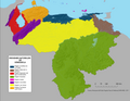
The Venezuelan Andean system represents the terminal bifurcation of the Cordillera Oriental de Colombia, which in Venezuelan territory consists of two mountainous branches: the Sierra de Perijá, smaller, slightly displaced from southwest to northeast with 7,500 km2 in Venezuela; and a larger, frankly oriented Southwest to northeast with about 40,000 km2, the Cordillera de Mérida, commonly known as the proper Venezuelan Andes. [1] The highest point in Venezuela is located in this natural region. [2] It covers around 5.2% of the national territory, being the 4th largest natural region in Venezuela.

Geography

Venezuelan Andes can be divided in two sections:

  1. Western Venezuelan Andes (Macizo del Tamá, Páramos Batallón y La Negra).
  2. Central Venezuelan Andes (Macizo del Sur, Sierra Nevada de Mérida, Sierra de la Culata, Sierra de Santo Domingo [3] ).
  3. North-Eastern Venezuelan Andes (Sierra de Trujillo, Sierra de Portuguesa, Lara Andes)

Geology

They have a common geological origin, which dates back to the Eocene period of the early Tertiary era, about 40-50 million years ago, coincides with the beginning of the contact of the three tectonic plates (Nazca, Caribbean and South American) that began their orographic rise.

Before the rise of the current Venezuelan Andes, between the Cambrian and Silurian periods, the so-called primitive Andes emerged, which already for the Triassic period (Mesozoic era) had been almost completely flattened because of the intense erosive process to which were subjected. [4]

Quaternary tectonics

It's characterized by the interaction of the three most important lithospheric plates in the region: Nazca, Caribbean and South American. A northwest-southwest oriented direction of compression produces vertical and horizontal deformation components, with the formation of thrusts align the Andean borders, and strike-slip faults. The split of Venezuelan Andes apparently began in the Late Eocene, and its present height was probably attained before the Quaternary.

During the Quaternary. the main active structures are the strike-slip faults. the principal one being the Boconó Fault Zone, with a measured dextral displacement of several millimeters per year. In the field this displacement is shown by the existence of fault trenches, fault depressions, sag ponds, offset ridges and lateral moraines. [5]

Glacial geology

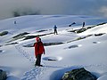
Like all tropical mountain ranges with altitudes above 3,000 m, the Venezuelan Andes were affected by Pleistocene glaciations.

Late Pleistocene glaciation

Two morainic complexes have been recognized in the Cordillera de Mérida: one between 2,600 and 2,800 m altitude, and another one between 2,900 and 3,500 m. These two levels have been considered as Early and Late Stades, respectively, of the Mérida glaciation. The moraines of the Late Stade are topographically well represented, and several superposed moraines, or morainic complexes, are found. The glaciated area in Cordillera de Mérida during the Last Glacial Maximum was approximately 600 km2 [6] [7] [8] [9]

In the Sierra de Perijá, the existence of moraines has been mentioned at altitudes between 2,700 and 3,100 m. In the absence of more detailed data, these have been tentatively assigned to the Late Stade of the Mérida glaciation. [10]

Late Holocene glaciation

Evidence of Late Holocene morainic sedimentation are based on palynological and radiocarbon analyses, which established a cold phase between the 15th and middle-19th centuries, which can be correlate with the Little Ice Age. The moraines associated with this phase are most probably those located at an altitude of approximately 4,700 m between 100 and 200 below the terminal zone of present-day glaciers. [11]

See also

Related Research Articles

<span class="mw-page-title-main">Andes</span> Mountain range in South America

The Andes, Andes Mountains or Andean Mountain Range are the longest continental mountain range in the world, forming a continuous highland along the western edge of South America. The range is 8,900 km (5,530 mi) long, 200 to 700 km wide, and has an average height of about 4,000 m (13,123 ft). The Andes extend from north to south through seven South American countries: Venezuela, Colombia, Ecuador, Peru, Bolivia, Chile, and Argentina.

<span class="mw-page-title-main">Mérida (state)</span> State of Venezuela

The State of Mérida commonly known simply as Mérida is one of the 23 states of Venezuela. The state capital is Mérida, in the Libertador Municipality.

<span class="mw-page-title-main">Last Glacial Period</span> Period of major glaciations of the northern hemisphere (115,000–12,000 years ago)

The Last Glacial Period (LGP), also known colloquially as the last ice age or simply ice age, occurred from the end of the Eemian to the end of the Younger Dryas, encompassing the period c. 115,000 – c. 11,700 years ago. The LGP is part of a larger sequence of glacial and interglacial periods known as the Quaternary glaciation which started around 2,588,000 years ago and is ongoing. The definition of the Quaternary as beginning 2.58 million years ago (Mya) is based on the formation of the Arctic ice cap. The Antarctic ice sheet began to form earlier, at about 34 Mya, in the mid-Cenozoic. The term Late Cenozoic Ice Age is used to include this early phase. The previous ice age, the Saale glaciation, which ended about 128,000 years ago, was more severe than the Last Glacial Period in some areas such as Britain, but less severe in others.

<span class="mw-page-title-main">Cordillera de Mérida</span>

The Cordillera de Mérida is a series of mountain ranges, or massif, in northwestern Venezuela. The Cordillera de Mérida is a northeastern extension of the Andes Mountains and the most important branch of the Venezuelan Andes. The ranges run southwest–northeast between the Venezuelan-Colombian border and the Venezuelan Coastal Ranges. The Táchira depression separates the Cordillera de Mérida from the Cordillera Oriental, which forms the Colombia-Venezuela border.

<span class="mw-page-title-main">Cordillera Oriental (Colombia)</span>

The Cordillera Oriental is the widest of the three branches of the Colombian Andes. The range extends from south to north dividing from the Colombian Massif in Huila Department to Norte de Santander Department where it splits into the Serranía del Perijá and the Cordillera de Mérida in Venezuelan Andes. The highest peak is Ritacuba Blanco at 5,410 m (17,750 ft) in the Sierra Nevada del Cocuy.

<span class="mw-page-title-main">Sierra Nevada de Mérida</span>

The Sierra Nevada de Mérida is the highest mountain range in the largest massif in Venezuela, the Cordillera de Mérida, which in turn is part of the northern extent of the Cordillera de los Andes. The Sierra Nevada de Mérida includes the highest peaks in Venezuela, Pico Bolívar, which has an elevation of 4,981 metres (16,342 ft), Pico Humboldt, Pico Bonpland and others.

<span class="mw-page-title-main">Sierra Nevada del Cocuy</span>

The Sierra Nevada del Cocuy Chita or Guican National Natural Park (or Sierra Nevada de Chita or Sierra Nevada de Güicán, Spanish: Parque Natural Sierra Nevada del Cocuy Chita o Guican is a national park and a series of highlands and glaciated peaks located within the Cordillera Oriental mountain range in the Andes Mountains of Colombia, at its easternmost point. It also corresponds to the highest range of the Eastern Cordillera and holds the biggest glacial mass in South America, north of the Equator. Since 1977, this region is protected within a National Natural Park because of its fragile páramos, extraordinary bio-diversity and endemism, and its function as a corridor for migratory species under conditions of climate change. Among the Sierra’s natural attractions are the remaining 18 ice-covered peaks, glacial lakes and waterfalls.

<span class="mw-page-title-main">Climate of Venezuela</span>

The Climate of Venezuela is characterized for being tropical and megathermal as a result of its geographical location near the Equator, but because of the topography and the dominant wind direction, several climatic types occur which can be the same as found in temperate latitudes, and even polar regions. Latitude exerts little influence on the Venezuelan While the coastal cities of Maracaibo, Barcelona, Porlamar and Maiquetia can get extremely hot, cities located at valleys such as Mérida, Caracas, Los Teques and San Cristobal have cooler climates, and the highest towns of Mucuchies and Apartaderos have cold (tundra) climates.

<i>Ardaris</i> Genus of butterflies

Ardaris is a Neotropical genus of firetips in the family Hesperiidae. It includes two endemic species that are restricted to mountain forests and páramos in the Cordillera de Mérida, Venezuela.

<span class="mw-page-title-main">Kettle Mucubají</span> Body of water

Kettle Mucubají is a glacial lake located in Sierra Nevada National Park, in the Mérida State of Venezuela. The lake is 3625–3655 metres above sea level. Kettle Mucubají is one of the biggest kettles in the valley and is one of the main tourist attractions in the area, which is known for its scenic beauty. In 2007, the Ramsar List of Wetlands of International Importance recognised the importance of Lake Mucubají in the region.

<span class="mw-page-title-main">Sierra Nevada National Park (Venezuela)</span> Venezuelan National Park

The Sierra Nevada National Park (PNSN) is an important National Park of Venezuela located between Mérida and Barinas states in the west of the country. It was created on May 2, 1952, by decree of President Germán Suárez Flamerich, in order to protect the Sierra Nevada de Mérida in the Andes.

<span class="mw-page-title-main">Sierra de la Culata</span>

The Sierra de La Culata is a mountain range in the largest massif in Venezuela, the Cordillera de Mérida, which in turn is part of the northern extent of the Cordillera de los Andes. The Sierra la Culata includes some of the highest peaks in Venezuela, such as Pico Piedras Blancas, Pico Pan de Azúcar, and Collado del Cóndor.

<span class="mw-page-title-main">Llanquihue glaciation</span> Last glacial period in southern Chile

The last glacial period and its associated glaciation is known in southern Chile as the Llanquihue glaciation. Its type area lies west of Llanquihue Lake where various drifts or end moraine systems belonging to the last glacial period have been identified. The glaciation is the last episode of existence of the Patagonian Ice Sheet. Around Nahuel Huapi Lake the equivalent glaciation is known as the Nahuel Huapi Drift.

<span class="mw-page-title-main">Natural regions of Venezuela</span>

Because of its natural structure, Venezuela can be divided into eight very distinct natural regions. In the evaluation of a natural region, the human element is not present. The natural region groups of Venezuela formed as a consequence of the association of geo-physical elements such as: geological constitution, relief, climate, hydrography, vegetation, soils, among others.

<span class="mw-page-title-main">Sierra La Culata National Park</span>

The Sierra La Culata National Park Also Sierra de la Culata National Park is a national park of Venezuela that is located in the northeastern branch of the Venezuelan Andes, in the states Mérida and Trujillo. It was decreed a national park on December 7, 1989. It has a high mountain climate, with temperatures ranging between −2 and 24 °C, and its surface area is 200,400 hectares (774 sq mi).

<span class="mw-page-title-main">Northern Andean páramo</span>

The Northern Andean páramo (NT1006) is an ecoregion containing páramo vegetation above the treeline in the Andes of Colombia and Ecuador. In the past, when the climate was cooler, the treeline and the páramo units were lower and the units were connected. During the present warmer Holocene epoch the páramos have migrated uphill, shrinking and becoming isolated. They contain many rare or endangered species, some of them restricted to a narrow area of one mountain or mountain range. The ecoregion is relatively well preserved, but faces threats from over-grazing and farming.

<span class="mw-page-title-main">Santa Marta páramo</span>

The Santa Marta páramo (NT1007) is an ecoregion containing páramo vegetation above the treeline in the Sierra Nevada de Santa Marta mountain range on the Caribbean coast of Colombia. The isolated position of the range has allowed unique species to evolve. Some are related to those found in Central America and the Caribbean coastal areas, and some to species from the Andes. The habitat is relatively stable, but has been drastically changed from the original by long-term human activity.

<span class="mw-page-title-main">Cordillera de Merida páramo</span>

The Cordillera de Merida páramo (NT1004) is an ecoregion containing páramo vegetation above the treeline in the Andes mountain range of Venezuela. The isolated habitat has many endemic species. It is relatively stable and intact.

<span class="mw-page-title-main">Venezuelan Andes montane forests</span>

The Venezuelan Andes montane forests (NT0175) is an ecoregion in the northern arm of the Andes in Venezuela. It contains montane and cloud forests, reaching up to the high-level Cordillera de Merida páramo high moor ecoregion. The forests are home to many endemic species of flora and fauna. Their lower levels are threatened by migrant farmers, who clear patches of forest to grow crops, then move on.

<span class="mw-page-title-main">Táchira Depression</span>

The Táchira Depression is a saddle of land connecting the Lake Maracaibo basin to the Orinoco basin in the state of Táchira, Venezuela. It forms a break in the eastern Andes, separating the Tamá Massif to the west from the Cordillera de Mérida to the east. The depression has been thought to present a barrier to the movement of species between the Colombian and Venezuelan Andes, but this effect may have been relatively low during the recent ice ages. The mountains of the region have potential for coffee farming and hydroelectric power generation, while the lower levels are suitable for farming.

References

  1. Vivas, Leonel (2012). Geotemas (in Spanish). San Cristobal, Venezuela: Fondo Editorial "Simón Rodriguez". ISBN   978-980-6838-57-4.
  2. Pérez et al (Sep. 2005): "Alturas del Pico Bolívar y otras cimas andinas venezolanas a partir de observaciones Gps." INCI v.30, n.4, Caracas sep. 2005. Retrieved 2012-09-27. (in Spanish)
  3. Sanchez Davila, Gabriel. "Sierra de Santo Domingo: Biogeographic reconstructions for the Quaternary of a former snowy mountain range". Academia (in Spanish). Retrieved 5 July 2019.
  4. Vargas Ponce, José; García, Pablo Emilio. Geografía: 9º Educación Básica (in Spanish). Ed. Romor. ISBN   978-980-6010-67-3.
  5. Schubert, Carlos; Vivas, Leonel (1993). El Cuaternario de la Cordillera de Mérida (in Spanish). Mérida, Venezuela: Universidad de Los Andes / Fundación Polar. ISBN   978-980-221-707-6.
  6. Schubert, Carlos (1998). "Glaciers of Venezuela". US Geological Survey (USGS P 1386-I).
  7. Schubert, C.; Valastro, S. (1974). "Late Pleistocene glaciation of Páramo de La Culata, north-central Venezuelan Andes". Geologische Rundschau. 63 (2): 516–538. Bibcode:1974GeoRu..63..516S. doi:10.1007/BF01820827. S2CID   129027718.
  8. Mahaney, William C.; Milner, M.W., Kalm, Volli; Dirsowzky, Randy W.; Hancock, R.G.V.; Beukens, Roelf P. (1 April 2008). "Evidence for a Younger Dryas glacial advance in the Andes of northwestern Venezuela". Geomorphology. 96 (1–2): 199–211. Bibcode:2008Geomo..96..199M. doi:10.1016/j.geomorph.2007.08.002.{{cite journal}}: CS1 maint: multiple names: authors list (link)
  9. Maximiliano, B.; Orlando, G.; Juan, C.; Ciro, S. "Glacial Quaternary geology of las Gonzales basin, páramo los conejos, Venezuelan andes".
  10. Schubert, Carlos (1976). "Evidence of former glaciation in the Sierra de Perijá, western Venezuela". Erdkunde. Erdkuner. 30 (3): 222–224. JSTOR   25641752.
  11. Rull, Valentí; Salgado-Labouriau, M.L.; Schubert, Carlos; Valastro, S. (1987). "Late Holocene temperature depression in the Venezuelan Andes: palynological evidence". Palaeogeography, Palaeoclimatology, Palaeoecology. 60: 109–21. Bibcode:1987PPP....60..109R. doi:10.1016/0031-0182(87)90027-7 . Retrieved 14 February 2017.