Natural regions of Venezuela

Last updated
Natural Regions of Venezuela Mapa de regiones naturales (Venezuela).png
Natural Regions of Venezuela

Percentage area of Venezuelan natural regions

   Guayana (48.22%)
   Los Llanos (26.61%)
   Sistema Coriano (5.75%)
   Andes (5.16%)
   Orinoco Delta (4.76%)
   Maracaibo Basin (4.02%)
  Insular (0.14%)

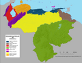
Because of its natural structure, Venezuela can be divided into eight very distinct natural regions. In the evaluation of a natural region, the human element is not present. The natural region groups of Venezuela formed as a consequence of the association of geo-physical elements such as: geological constitution, relief, climate, hydrography, vegetation, soils, among others. [1]

Contents

The regional groups that make up the Venezuelan territory are: [2]

Andean Region

The Venezuelan Andean system represents the terminal bifurcation of the Cordillera Oriental de Colombia, which in Venezuelan territory consists of two mountainous branches: the Sierra de Perija, smaller, slightly displaced from southwest to northeast with 7,151 km2 in Venezuela; and a larger, frankly oriented Southwest to northeast with about 40,172 km2, the Cordillera de Mérida, commonly known as the proper Venezuelan Andes. [3] The highest point in Venezuela is located in this natural region. [4]

It is divided in two sections:

Cordillera de La Costa Region

Is a mountain range system, that runs along the central and eastern portions of Venezuela's northern coast. The range is a northeastern extension of the Andes, and is also known as the Maritime Andes. The Coastal Range actually consists of two parallel ranges, which run east and west along the coast of the Caribbean Sea. The Cojedes River separates the western end of Coastal Range from the Cordillera de Mérida to the southeast. The range is divided into eastern and western sections by the wide bay between Cape Codera and Cumaná.

Guayana Region

is a large massif of approximately 441,921 km2 of extension, equivalent to 48.2% of the total continental territory of the country. [5] Its limits by the north and east is formed by the route of the rivers Orinoco, Atabapo and Negro and by the south the borders with Brazil. Th region occupies almost half of meridional territory of Venezuela.

Insular Region

It comprises all of the nation's islands, and is formed by the state of Nueva Esparta and the Federal Dependencies.

Los Llanos Region

Is a large central depression very flat in a vast natural region of approximately 243,8692 of extension, equivalent to 26.61% of the total continental territory of the country.

Maracaibo Basin Region

Is a foreland basin, found in the northwestern corner of Venezuela in South America. Covering over 35,000 square km, it is a hydrocarbon-rich region that has produced over 30 billion bbl of oil with an estimated 44 billion bbl yet to be recovered. The basin is characterized by a large shallow tidal estuary, Lake Maracaibo, located near its center.

Orinoco Delta Region

Is fan-shaped river delta, formed by the Orinoco River as it splits into numerous distributaries, called caños, which meander through the delta on their way to the sea. The main distributary is called the Rio Grande, which empties south-southeast through the southern portion of the delta, and the second major distributary is Caño Manamo, which runs northward along the western edge of the delta.

Lara-Falcón Highlands Region

Is the hilly and semi-mountainous area in northwest Venezuela. It consists mostly of east-west running ridges, with the exception of the Sierra de Siruma or Empalado which run north-south. The coastal plain of the region contains Venezuela's only desert, the Médanos de Coro (the Coro Dunes), on the Paraguaná Peninsula.

Related Research Articles

Geography of Colombia

The Republic of Colombia is largely situated in the northwest of South America, with some territories falling within the boundaries of Central America. It is bordered to the northwest by Panama; to the east by Venezuela and Brazil; to the south by Ecuador and Peru; and it shares maritime limits with Costa Rica, Nicaragua, Honduras, Jamaica, the Dominican Republic, and Haiti. Colombia has a land size of 1,138,910 km2 (439,740 sq mi) and it is the 25th largest nation in the world and the fourth-largest country in South America. Despite its large territory, Colombia's population is not evenly distributed, with most Colombians living in the mountainous western portion of the country as well as the northern coastline, most living in or near the capital city of Bogotá. The southern and eastern portions of the country are mostly sparsely inhabited tropical rainforest, and inland tropical plains containing large estates or large livestock farms, oil and gas production facilities, small farming communities and indigenous tribes. Colombia has the 35th largest Exclusive Economic Zone of 808,158 km2 (312,032 sq mi).

Apure River river in Venezuela

The Apure River is a river of southwestern Venezuela, formed by the confluence of the Sarare and Uribante near Guasdualito, in Venezuela, at 7°15′N70°40′W, and flowing across the llanos into the Orinoco. It provides significant transportation in the area.

A cordillera is an extensive chain of mountains or mountain ranges. The term is a borrowed from Spanish, with the same meaning. The Spanish word originates from cordilla, a diminutive of "cuerda" or "rope". It is most commonly used in the field of physical geography.

Maracaibo Basin

The Maracaibo Basin, also known as Lake Maracaibo natural region, Lake Maracaibo depression or Lake Maracaibo Lowlands, is a foreland basin and one of the eight natural regions of Venezuela, found in the northwestern corner of Venezuela in South America. Covering over 36,657 square km, it is a hydrocarbon-rich region that has produced over 30 billion bbl of oil with an estimated 44 billion bbl yet to be recovered. The basin is characterized by a large shallow tidal estuary, Lake Maracaibo, located near its center. The Maracaibo basin has a complex tectonic history that dates back to the Jurassic period with multiple evolution stages. Despite its complexity, these major tectonic stages are well preserved within its stratigraphy. This makes The Maracaibo basin one of the most valuable basins for reconstructing South America's early tectonic history.

Orinoco Delta

The Orinoco Delta is a vast river delta of the Orinoco River, located in eastern Venezuela.

Cordillera de Mérida mountain range

The Cordillera de Mérida is a series of mountain ranges, or massif, in northwestern Venezuela. The Cordillera de Mérida is a northeastern extension of the Andes Mountains and the most important branch of the Venezuelan Andes. The ranges run southwest-northeast between the Venezuelan-Colombian border and the Venezuelan Coastal Ranges. The Táchira depression separates the Cordillera de Mérida from the Cordillera Oriental, which forms the Colombia-Venezuela border.

Serranía del Perijá mountains in Venezuela

The Serranía del Perijá, Cordillera de Perijá or Sierra de Perijá is a mountain range, an extension of the eastern Andean branch, in northern South America, between Colombia and Venezuela, ending further north in the Guajira Desert, a total distance of about 310 kilometres (190 mi). It separates the Maracaibo Basin from the Cesar-Ranchería Basin. Some of the area has been considered as a Flora and Fauna Sanctuary.

Coro region Geographic/Natural Region in Venezuela

The Sistema Coriano also known as Lara-Falcón Formation, Coro region or Coriano system is one of the eight natural regions of Venezuela. Is the hilly and semi-mountainous area in northwest Venezuela, north of the Mérida Andes and east of the Maracaibo Basin, extending north to the Caribbean coast. It consists mostly of east-west running ridges, with the exception of the Sierra de Siruma or Empalado which run north-south.

Cordillera Oriental (Colombia) mountain range in Colombia

The Cordillera Oriental is the widest of the three branches of the Colombian Andes. The range extends from south to north dividing from the Colombian Massif in Huila Department to Norte de Santander Department where it splits into the Serranía del Perijá and the Cordillera de Mérida in Venezuelan Andes. The highest peak is Ritacuba Blanco at 5,410 m (17,750 ft) in the Sierra Nevada del Cocuy.

The Regions of Venezuela are two groupings of Venezuela's states, capital district, and federal dependencies. Venezuela's Natural regions are divided by natural geography, and Administrative regions are delineated for the purpose of regional administration.

Venezuelan Coastal Range mountain in Venezuela

The Venezuelan Coastal Range, also known as Venezuelan Caribbean Mountain System is a mountain range system and one of the eight natural regions of Venezuela, that runs along the central and eastern portions of Venezuela's northern coast. The range is a northeastern extension of the Andes, and is also known as the Maritime Andes. It covers around 48,866 km2, being the 4th largest natural region in Venezuela.

Sierra Nevada de Mérida glacier

The Sierra Nevada de Mérida is the highest mountain range in the largest massif in Venezuela, the Cordillera de Mérida, which in turn is part of the northern extent of the Cordillera de los Andes. The Sierra Nevada de Mérida includes the highest peaks in Venezuela, Pico Bolívar, which has an elevation of 4,981 metres (16,342 ft), Pico Humboldt, Pico Bonpland and others.

Geology of Colombia

Geology of Colombia refers to the geological composition of the Republic of Colombia that determines its geography. Most of the emerged territory of Colombia covers vast areas within the South American plate, whereas much submerged territory lies within the Caribbean plate and the Nazca plate.

The Climate of Venezuela is characterized for being tropical and isothermal as a result of its geographical location near the Equator, but because of the topography and the dominant wind direction, several climatic types occur which can be the same as found in temperate latitudes, and even polar regions. Latitude exerts little influence on the Venezuelan climate, but the altitude changes it dramatically, particularly the temperature, reaching values very different according to The weather.

Venezuelan Andes

The Venezuelan Andes also simply known as the Andes in Venezuela, are a mountain system that form the northernmost extension of the Andes. They are fully identified, both by their geological origin as by the components of the relief, the constituent rocks and the geological structure.

Venezuelan Llanos Geographic/Natural Region in Venezuela

The Venezuelan Llanos also simply known as Los Llanos in Venezuela, is a large central depression very flat in a vast natural region of approximately 243,774 km2 of extension, equivalent to 26.6% of the total continental territory of the country.

Guayana natural region Geographic/Natural Region in Amazonas, Venezuela

The Guayana natural region also simply known as Guayana in Venezuela, is a large massif of approximately 441,726 km2 area, equivalent to 48.2% of the total continental territory of the country.

Mariusa National Park

The Mariusa National Park Also Delta del Orinoco National Park Is a protected area of Venezuela. with national park status

Catatumbo moist forests

The Catatumbo moist forests (NT0108) is an ecoregion in Venezuela and Colombia to the west and east of Lake Maracaibo. It includes four regions of moist forest on slightly higher ground than the dry forest and mangroves that surround the lake. The forest has unique flora related to the flora of the Amazon basin. It is badly degraded due to farming, livestock grazing and oil exploration.

Maracaibo dry forests

The Maracaibo dry forests (NT0222) is an ecoregion in Venezuela around Lake Maracaibo. It contains the country's main oil fields. The habitat is criss-crossed by roads and is severely degraded by farming and livestock grazing.

References

  1. Imagen de Venezuela: una visión espacial (in Spanish). Caracas, Venezuela: Petróleos de Venezuela S.A. 1992. ISBN   980-259-475-X.
  2. Vargas Ponce, José; García, Pablo Emilio. Geografía: 9º Educación Básica (in Spanish). Ed. Romor. p. 45. ISBN   980-6010-67-1.
  3. Vivas, Leonel (2012). Geotemas (in Spanish). San Cristobal, Venezuela: Fondo Editorial "Simón Rodriguez". ISBN   978-980-6838-57-4.
  4. Pérez et al (Sep. 2005): "Alturas del Pico Bolívar y otras cimas andinas venezolanas a partir de observaciones Gps." INCI v.30, n.4, Caracas sep. 2005. Retrieved 2012-09-27. (in Spanish)
  5. Vargas Ponce, José; García, Pablo Emilio. Geografía: 9º Educación Básica (in Spanish). Ed. Romor. ISBN   980-6010-67-1.