
Palmer Creek is a waterway in the Kenai Peninsula, Alaska, US. It is an affluent of Resurrection Creek, itself a tributary of Turnagain Arm.
Palmer Creek is a waterway in the Kenai Peninsula, Alaska, US. It is an affluent of Resurrection Creek, itself a tributary of Turnagain Arm.
Palmer Creek flows northwest for 11 miles (18 km) before reaching Resurrection Creek. Hope is located 4.5 miles (7.2 km) to the north. [1] Its upper portion flows for 6 miles (9.7 km) through a broad, round-bottomed valley, while its lower part occupies a steep, narrow canyon rut through rock in some places and through gravel benches in others. Mining has been carried on chiefly in the lower 1.5 miles (2.4 km) of the stream and has been confined entirely to the channel gravels. The country rock includes interbedded slates and arkoses, whose cleavage strikes a little east of north and dips at a high angle. The arkoses are frequently very much jointed and in weathering do not break into small pieces as easily as do the slates, a fact readily seen on examining tho stream wash. The gravels resemble the country rock in their composition, and were undoubtedly derived from it in large part, although there are a few granitic bowlders which may not be of local origin. There is a large proportion of angular fragments and no small percentage of coarse material, possibly 5 percent being over 1.5 feet (0.46 m) in diameter. At the surface, the gravels were laid down without definite arrangement but are rudely stratified below. Palmer Creek gold is coarse and heavy, flattened, and smooth. In color, it is bright yellow or whitish. Pieces of native silver have been noted. [2]
Gold was found on Palmer Creek in 1894 by George Palmer, a trader in the Knik Arm area in the late 1800s. These discoveries led to prospecting on neighboring streams, and in the following year (1895) the first stakes were driven on Mills Creek by S. J. Mills, whose name it bears, and at the forks of Sixmile Creek, also named by Mills. The gold claims on this stream were originally held by single individuals. Two hydraulic plants were at work in 1904, employing approximately 10 men. By 1915, the whole of the lower canyon portion, 18 claims, was controlled by one company. In 1915, it was reported that most of the prospects on Palmer Creek were on a mineralized acidic dike. The dike was first discovered in 1898 on Coeur d'Alene Gulch by an Australian outfit, but no development work was done. Later, John Hirshey and Elmer Carlson located the dike in Ptarmigan Gulch about a mile south of the original discovery and W. A. Logman relocated the dike on Coeur d'Aleno Gulch. [2] The Lucky Strike mine, managed by John Hirshey, reported activity in 1931. [3]

Bear Creek is a census-designated place (CDP) in Kenai Peninsula Borough, Alaska, United States. At the 2020 census the population was 2,129 up from 1,956 in 2010. Bear Creek is a few miles north of Seward near the stream of the same name and its source, Bear Lake.
Cooper Landing is a census-designated place (CDP) in Kenai Peninsula Borough, Alaska, United States, about 100 miles (160 km) south of Anchorage, at the outlet of Kenai Lake into the Kenai River. The town was first settled in the 19th century by gold and mineral prospectors, and has become a popular summer tourist destination thanks to its scenic location and proximity to the salmon fishery of the Kenai River and Russian River. As of the 2010 census, the population in Cooper Landing was 289, down from 369 in 2000.

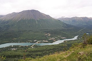
Hope is a census-designated place (CDP) in Kenai Peninsula Borough in the U.S. state of Alaska. It is eighty-seven miles south from Anchorage. As of the 2010 census the population was 192, up from 137 in 2000.
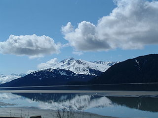
Turnagain Arm is a waterway into the northwestern part of the Gulf of Alaska. It is one of two narrow branches at the north end of Cook Inlet, the other being Knik Arm. Turnagain is subject to climate extremes and large tide ranges.

Hatcher Pass is a mountain pass through the southwest part of the Talkeetna Mountains, Alaska. It is named after Robert Hatcher, a prospector and miner. The nearest cities are Palmer and Wasilla approximately 12 miles (19 km) to the south, and Willow approximately 26 mi (42 km) to the west. The communities are at an elevation of approximately 250 ft (76 m) in the Mat-Su valley.

The Kugruk River is a stream, 60 miles (97 km) long, in the northwestern part of the U.S. state of Alaska. It is the largest tributary of the Kuzitrin River. It begins near Imuruk Lake on the Seward Peninsula and flows generally north to Kugruk Lagoon, at Kotzebue Sound on the Chukchi Sea. The river enters the lagoon 5.5 miles (8.9 km) southeast of Cape Deceit in the Northwest Arctic Borough.
The Tubutulik River is a waterway in the U.S. state of Alaska. The 25-mile (40 km) long river is situated on the Seward Peninsula. It flows southeastwards to the Kwiniuk Inlet at the northwestern end of Norton Bay, 25 miles (40 km) southwest of Koyuk in the Bering Sea. Its Inuit name was reported as "Tubuktulik" in 1849 by Capt. Mikhail Dmitrievich Tebenkov of the Imperial Russian Navy. Exploration for placer gold occurred in the Council district area where the river valley is located, and in 1898, mining commenced. The production was substantial and ranked second only to that of Nome.
Gold mining in Alaska, a state of the United States, has been a major industry and impetus for exploration and settlement since a few years after the United States acquired the territory in 1867 from the Russian Empire. Russian explorers discovered placer gold in the Kenai River in 1848, but no gold was produced. Gold mining started in 1870 from placers southeast of Juneau, Alaska.
Young Creek is an east tributary of Nizina River in the U.S. state of Alaska. The stream, which serves as the main drainage on the north side of MacColl Ridge, flows through the Wrangell–St. Elias National Park and Preserve.

Sheep Creek is located 4 miles (6.4 km) southeast of Juneau, in the U.S. state of Alaska. The Juneau community of Thane was originally called Sheep Creek. Draining an area of about 5 square miles (13 km2), it empties into Gastineau Channel. The valley formed by the river has a flat, gravel, trekking trail of 3.5 miles (5.6 km), south of Mount Roberts. The Snettisham hydroelectric dam substation is situated on a trail spur. Sheep Creek Hatchery is located at the outflow.
Candle Creek is a western tributary of the Kiwalik River, located on the Seward Peninsula of the U.S. state of Alaska. The unincorporated community of Candle is less than a mile away, while the village of Kiwalik is about 13 miles (21 km) away. The creek's name is attributed to the resemblance of the trees on the banks of the creek to candles when they are covered with snow. With the discovery of gold in 1901, Candle Creek's reputation as a top gold-yielding site was fixed.
Casadepaga River is a waterway in the U.S. state of Alaska, near Nome. It is the largest southern branch of the Niukluk River. It has a length of about 30 miles (48 km) and a general northeasterly course.
Fox River is a waterway on the Seward Peninsula in the U.S. state of Alaska. It is 32 miles (51 km) from Solomon. The Fox flows eastward for 18 miles (29 km) before reaching the Fish River from the west.
Nome River is a waterway on the Seward Peninsula in the U.S. state of Alaska. It has its source in a narrow valley in the southern margin of the Kigluaik Mountains, 4.5 miles (7.2 km) west of Salmon Lake.
Lost River (Inupiaq: Amaaqtulik) is a waterway on the Seward Peninsula of the U.S. state of Alaska. Rising in the York Mountains, the river empties into the Bering Sea, 10 miles (16 km) west of Port Clarence. It is located 10 miles (16 km) east of Cape York.

Crow Creek is a stream in the Chugach Mountains, Alaska, US. It is the only notable tributary of Glacier Creek, which enters Turnagain Arm from the north, 12 miles (19 km) from its eastern end. The stream is notable as the site of ongoing gold mining since the late 19th century.

Resurrection Creek is a waterway in the Kenai Peninsula, Alaska, US. Along with Bear Creek, Sixmile Creek, and Glacier Creek, it is a tributary of Turnagain Arm. The stream's watershed drains 161 square miles (420 km2) on the north side of the Kenai Peninsula, and the community of Hope, Alaska is located at the creek's mouth. The Hope Highway passes alongside Resurrection Creek.
Valdez Creek is one of the small headwater tributaries of Susitna River in the U.S. state of Alaska.
The Hirshey Mine was one of the major gold mines in the northern mountains of the Kenai Peninsula in south-central Alaska in the first half of the 20th century. The mine was, unlike many local claims, an underground operation. It is located in the mountains of what is now Chugach National Forest, on the east side of Palmer Creek about 12 miles (19 km) southeast of the community of Hope. The claim was staked in 1911 John Hirshey, who arrived in the area in 1895 and was one of the early settlers of Hope. He called the claim his "Lucky Strike", and it was worked until all mines were closed in the area in 1942. When the area was listed on the National Register of Historic Places in 1978, remnants of two buildings survived, along with the entrance to one of the tunnels and discarded equipment.

Glacier Creek is a 10 miles long stream flowing out of the Chugach Mountains, which enters the Turnagain Arm of Cook Inlet near Girdwood, Alaska.