Resurrection Creek

Last updated
Mouth of Resurrection Creek Camped in Hope.jpg
Mouth of Resurrection Creek

Resurrection Creek is a waterway in the Kenai Peninsula, Alaska, US. Along with Bear Creek, Sixmile Creek, and Glacier Creek, it is a tributary of Turnagain Arm. The stream's watershed drains 161 square miles (420 km2) on the north side of the Kenai Peninsula, and the community of Hope, Alaska is located at the creek's mouth. [1] The Hope Highway passes alongside Resurrection Creek.

Waterway Any navigable body of water

A waterway is any navigable body of water. Broad distinctions are useful to avoid ambiguity, and disambiguation will be of varying importance depending on the nuance of the equivalent word in other languages. A first distinction is necessary between maritime shipping routes and waterways used by inland water craft. Maritime shipping routes cross oceans and seas, and some lakes, where navigability is assumed, and no engineering is required, except to provide the draft for deep-sea shipping to approach seaports (channels), or to provide a short cut across an isthmus; this is the function of ship canals. Dredged channels in the sea are not usually described as waterways. There is an exception to this initial distinction, essentially for legal purposes, see under international waters.

Kenai Peninsula peninsula

The Kenai Peninsula is a large peninsula jutting from the coast of Southcentral Alaska. The name Kenai is derived from the word "Kenaitze" or "Kenaitze Indian Tribe", the name of the Native Athabascan Alaskan tribe, the Kahtnuht’ana Dena’ina, that historically inhabited the area. They called the Kenai Peninsula Yaghanen.

Alaska State of the United States of America

Alaska is a U.S. state in the northwest extremity of the United States West Coast, just across the Bering Strait from Asia. The Canadian province of British Columbia and territory of Yukon border the state to the east and southeast. Its most extreme western part is Attu Island, and it has a maritime border with Russia to the west across the Bering Strait. To the north are the Chukchi and Beaufort seas—southern parts of the Arctic Ocean. The Pacific Ocean lies to the south and southwest. It is the largest U.S. state by area and the seventh largest subnational division in the world. In addition, it is the 3rd least populous and the most sparsely populated of the 50 United States; nevertheless, it is by far the most populous territory located mostly north of the 60th parallel in North America: its population—estimated at 738,432 by the United States Census Bureau in 2015— is more than quadruple the combined populations of Northern Canada and Greenland. Approximately half of Alaska's residents live within the Anchorage metropolitan area. Alaska's economy is dominated by the fishing, natural gas, and oil industries, resources which it has in abundance. Military bases and tourism are also a significant part of the economy.

Contents

Geography

Hope City was a mining camp for Resurrection Creek, established in 1896 HOPE HISTORIC DISTRICT.jpg
Hope City was a mining camp for Resurrection Creek, established in 1896

Resurrection Creek, the earliest gold producer of the region, flows through a broad valley floored with a thick deposit of gravels, in which, throughout the greater part of its length, the waters have cut a deep, canyon-like channel. The portion from which gold has been taken, lying between Sixmile Point and Hope, has an average grade of 66 feet (20 m) per mile, the grade of the lower 20 miles (32 km) being about 100 feet (30 m) per mile. The valley gravels are roughly stratified and have been penetrated in one place to a depth of 50 feet (15 m) below the stream level without reaching solid rock. They consist largely of slates and arkoses from the neighboring hills, but contain, in addition, an uncertain percentage of material, chiefly granitic in character, foreign to the valley. [2]

Hope, Alaska Census-designated place in Alaska, United States

Hope is a census-designated place (CDP) in Kenai Peninsula Borough in the U.S. state of Alaska. As of the 2010 census the population was 192, up from 137 in 2000.

Tributaries

Palmer Creek is the largest tributary of Resurrection Creek. [2]

Palmer Creek is a waterway in the Kenai Peninsula, Alaska, US. It is an affluent of Resurrection Creek, itself a tributary of Turnagain Arm.

Bear Creek is the best known stream in this part of the field. It is about 5 miles (8.0 km) long and has a fall of nearly 500 feet (150 m) to the mile. Bear Creek valley is narrower than Palmer Creek valley, and while resembling it in some ways, does not have the canyon features so well developed. The country rock is a succession of arkoses inlerstratified with bluish-black slates, the beds being so thin in one or two localities as to give to the outcrops a banded structure. These beds strike N. 20° E., or nearly at right angles to the general course of the creek, the cleavage, however, running more nearly north and south. The gravels are very irregular in distribution and are made up almost entirely of material like the country rock, but include, in addition, a few bowlders of granitic rock. In two places between 25–30 feet (7.6–9.1 m) of unstratified deposits were seen. These contain a large quantity of coarse angular blocks mixed with sands and clays, the whole apparently dumped into its present position without having undergone any sorting by water. Bowlders 3–4 feet (0.91–1.22 m) in diameter are plentiful. In some localities, the surface wash is underlain by stratified sands and clays, which were probably deposited in small local basins, where they are sometimes found abutting against perpendicular rock faces or overlapping sloping surfaces. The hard gray clay locally underlying the surface wash and known as "glacial clay" rests on loose sands composcd largely of slate particles and containing a large amount of water. It has been noticed in a few plates that the rock surface above this clay is worn smooth, while below it is rough and unworn. Bear Creek gold is lower in grade than any other from the Resurrection region. Like that from Palmer Creek, it is usually bright yellow in color, but may be whitish. Some native silver is found, and it is said that a small amount of native copper is also present. One large nugget of gold, valued at about $250, was found. The first claim staked on the stream yielded a little more than $2,000 the first year it was worked, but was not operated with profit in the following years. A second claim worked steadily, but in a small way, sinco the early days of Bear Creek's history has produced an average of $8 a day per man. Two hydraulic plants were installed on Bear Creek. [2]

Native copper Mineral (as opposed to the chemical element)

Native copper is an uncombined form of copper that occurs as a natural mineral. Copper is one of the few metallic elements to occur in native form, although it most commonly occurs in oxidized states and mixed with other elements. Native copper was an important ore of copper in historic times and was used by pre-historic peoples.

History

In the 1890s, Resurrection Creek was the site of Alaska's first gold rush. [3] Charles Miller located the first claim on the creek before leasing it to others for working. By 1893, about a dozen miners were working claims on at the creek. In the following year, even more claims were established on Resurrection Creek. [4] Tyonek was a major port during the Resurrection Creek gold rush of the 1880s-90s, but declined after Anchorage was established.

Gold rush new discovery of gold that brings an onrush of miners seeking their fortune

A gold rush is a new discovery of gold—sometimes accompanied by other precious metals and rare earth minerals—that brings an onrush of miners seeking their fortune. Major gold rushes took place in the 19th century in Australia, New Zealand, Brazil, Canada, South Africa and the United States, while smaller gold rushes took place elsewhere.

Tyonek, Alaska Census-designated place in Alaska, United States

Tyonek is a census-designated place (CDP) in Kenai Peninsula Borough in the U.S. state of Alaska. As of the 2010 census the population was 171, down from 193 in 2000. In 1973, the community formed the Tyonek Native Corporation (TNC) under the Alaska Native Claims Settlement Act and is federally recognized.

Anchorage, Alaska Consolidated city-borough in Alaska, United States

Anchorage is a unified home rule municipality in the U.S. state of Alaska, located in the West Coast of the United States. With an estimated 298,192 residents in 2016, it is Alaska's most populous city and contains more than 40 percent of the state's total population; among the 50 states, only New York has a higher percentage of residents who live in its most populous city. All together, the Anchorage metropolitan area, which combines Anchorage with the neighboring Matanuska-Susitna Borough, had a population of 401,635 in 2016, which accounts for more than half of the state's population. At 1,706 square miles of land area, the city is the fourth largest city by land in the United States and larger than the smallest state, Rhode Island, at 1,212 square miles.

Related Research Articles

Bear Creek, Alaska Census-designated place in Alaska, United States

Bear Creek is a census-designated place (CDP) in Kenai Peninsula Borough, Alaska, United States. At the 2010 census the population was 1,956, up from 1,748 in 2000. Bear Creek is a few miles north of Seward near the stream of the same name and its source, Bear Lake.

Kenai Fjords National Park national park of the United States

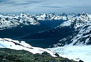
Kenai Fjords National Park is an American national park established in 1980 by the Alaska National Interest Lands Conservation Act. The park covers an area of 669,984 acres on the Kenai Peninsula in south-central Alaska, near the town of Seward. The park contains the Harding Icefield, one of the largest ice fields in the United States. The park is named for the numerous fjords carved by glaciers moving down the mountains from the ice field. The field is the source of at least 38 glaciers, the largest of which is Bear Glacier. The fjords are glacial valleys that have been submerged below sea level by a combination of rising sea levels and land subsidence. The park lies just to the west of Seward, a cruise ship port. Exit Glacier is a popular destination at the end of the park's only road. The remainder of the park is accessible by boat, airplane, and hiking.

Turnagain Arm

Turnagain Arm is a waterway into the northwestern part of the Gulf of Alaska. It is one of two narrow branches at the north end of Cook Inlet, the other being Knik Arm. Turnagain is subject to climate extremes and large tide ranges.

Hatcher Pass mountain pass

Hatcher Pass, also known as Hatcher's Pass, is a mountain pass through the southwest part of the Talkeetna Mountains, Alaska. It is named after Robert Hatcher, a prospector and miner. The nearest cities are Palmer and Wasilla approximately 12 miles (19 km) to the south, and Willow approximately 26 mi (42 km) to the west. The communities are at an elevation of approximately 250 ft (76 m) in the Mat-Su valley.

Bear Lake (Alaska) lake on the Kenai Peninsula in Alaska, United States

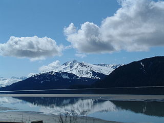
Bear Lake is near the town of Seward and Resurrection Bay, in the Kenai Peninsula Borough on the Kenai Peninsula in the U.S. state of Alaska. It is accessible from Bear Creek Road, which connects it to the Seward Highway. It is the site of salmon enhancement activities since 1962. This program is now managed by the Cook Inlet Aquaculture Association. Current projects at Bear Lake focus on increasing sockeye and coho salmon by controlling species that are predators and competitors.

Sixmile Creek is a short, approximately 12 miles (19 km) waterway with some of the most exciting whitewater rafting in Alaska. The Six Mile Creek drainage starts as Granite Creek flowing from the top of Turnagain Pass on the Seward Highway, part of the National Scenic Highway Program. Bench Creek and Center Creek join to become East Fork Six Mile Creek and Granite Creek is the largest tributary, contributing most of the water. At the confluence with Canyon Creek, it becomes Six Mile Creek which flows about eight miles to where it empties into Turnagain Arm shortly after flowing past the ghost town of Sunrise along the Hope Highway. There is a scenic outlook just before the Hope Junction with a grand view of the confluence of the creeks and the Canyon Creek Bridge that is pictured on the State of Alaska's website.

Gold mining in Alaska Alaska Mining District

Gold mining in Alaska, a state of the United States, has been a major industry and impetus for exploration and settlement since a few years after the United States acquired the territory from Russia. Russian explorers discovered placer gold in the Kenai River in 1848, but no gold was produced. Gold mining started in 1870 from placers southeast of Juneau, Alaska.

Sheep Creek (Juneau, Alaska)

Sheep Creek is located 4 miles (6.4 km) southeast of Juneau, in the U.S. state of Alaska. The Juneau community of Thane was originally called Sheep Creek. Draining an area of about 5 square miles (13 km2), it empties into Gastineau Channel. The valley formed by the river has a flat, gravel, trekking trail of 3.5 miles (5.6 km), south of Mount Roberts. The Snettisham hydroelectric dam substation is situated on a trail spur. Sheep Creek Hatchery is located at the outflow.

Candle Creek

Candle Creek is a western tributary of the Kiwalik River, located on the Seward Peninsula of the U.S. state of Alaska. The unincorporated community of Candle is less than a mile away, while the village of Kiwalik is about 13 miles (21 km) away. The creek's name is attributed to the resemblance of the trees on the banks of the creek to candles when they are covered with snow. With the discovery of gold in 1901, Candle Creek's reputation as a top gold-yielding site was fixed.

Kruzgamepa River river in the United States of America

The Kruzgamepa River is a 55-mile (89 km) tributary of the Kuzitrin River on the Seward Peninsula in the U.S. state of Alaska. The river begins at Salmon Lake, elevation 447 feet (136 m), and descends to 20 feet (6.1 m) above sea level at its mouth. In turn, the Kuzitrin River empties into the Imuruk Basin. The basin drains via the bay of Port Clarence to the Bering Sea.

Casadepaga River river in the United States of America

Casadepaga River is a waterway in the U.S. state of Alaska, near Nome. It is the largest southern branch of the Niukluk River. It has a length of about 30 miles (48 km) and a general northeasterly course.

Eldorado River is a waterway on the Seward Peninsula]] in the U.S. state of Alaska. It is situated 14 miles (23 km) west of Solomon. This river has its source within a few miles of Salmon Lake, from which it is separated by a low divide. It flows southeast through a broad gravel-filled valley for 30 miles (48 km) to Flambeau River before emptying into Safety Sound. Its headwaters reach the limestones of the Nome series and much of its course lies in a chlorite-albite-schist belt. The Eldorado River provides a southerly drainage into the Bering Sea.

Minook Creek is a waterway in the U.S. state of Alaska. It is named after John Mynook Pavaloff, a half-Russian/half-native Alaskan, who found gold in the river's valley in 1894.

Eureka Creek is a tributary of Baker Creek in the U.S. state of Alaska. Other Baker tributaries in the vicinity of Eureka Creek include Thanksgiving, Gold Run, and Pioneer creeks with Seattle Junior Creek a tributary of Pioneer.

Crow Creek is a stream in the Chugach Mountains, Alaska, US. It is the only notable tributary of Glacier Creek, which enters Turnagain Arm from the north, 12 miles (19 km) from its eastern end. The stream is notable as the site of ongoing gold mining since the late 19th century.

Miller Creek is a stream in Yukon, Canada.

Glacier Creek (Turnagain Arm)

Glacier Creek is a stream flowing out of the Chugach Mountains, which enters the Turnagain Arm of Cook Inlet near Girdwood, Alaska.

Resurrection River

The Resurrection River is a large river on the Kenai Peninsula in Alaska. It rises near Upper Russian Lake in the Kenai Mountains and flows 22 miles (35 km) to empty into Resurrection Bay near Seward. Part of the river passes through Kenai Fjords National Park. There has been small-scale placer mining for gold at the confluence of the river and Placer Creek.

References

The public domain consists of all the creative works to which no exclusive intellectual property rights apply. Those rights may have expired, been forfeited, expressly waived, or may be inapplicable.

  1. "Resurrection Creek Restoration Phase II Project Environmental Impact Statement". Federal Register Environmental Documents. US EPA. 29 October 2009. Retrieved 26 April 2014.
  2. 1 2 3 Martin, George Curtis; Johnson, Bertrand Leroy; Grant, Ulysses Sherman (1915). Geology and Mineral Resources of Kenai Peninsula, Alaska (Public domain ed.). U.S. Government Printing Office. pp. 193, 195, 196–.
  3. Martin, George Curtis; Johnson, Bertrand Leroy; Grant, Ulysses Sherman (1915). Geology and Mineral Resources of Kenai Peninsula, Alaska Issue 587 of Bulletin (Geological Survey (U.S.)) United States. Geological survey. Bulletin 587 Volume 587 of U.S. Geological Survey bulletin. ISBN   1130765032 | ISBN   9781130765038
  4. Mining in Alaska's Past, Alaska Historical Society, 1980

Coordinates: 60°55′36″N149°38′40″W / 60.92667°N 149.64444°W / 60.92667; -149.64444