
A toll road, also known as a turnpike or tollway or toll gate, is a public or private road for which a fee is assessed for passage. It is a form of road pricing typically implemented to help recoup the costs of road construction and maintenance.

The Garden State Parkway (GSP) is a controlled-access toll road that stretches the north–south length of eastern New Jersey from the state's southernmost tip near Cape May north to the New York state line at Montvale. Its name refers to New Jersey's nickname, the "Garden State". The parkway is designated by the New Jersey Department of Transportation (NJDOT) as Route 444, although this designation is unsigned. At its north end, the road becomes the Garden State Parkway Connector, a component of the New York State Thruway system that connects to the Thruway mainline in Ramapo.

A toll bridge is a bridge where a monetary charge is required to pass over. Generally the private or public owner, builder and maintainer of the bridge uses the toll to recoup their investment, in much the same way as a toll road.

Electronic toll collection (ETC) is a wireless system to automatically collect the usage fee or toll charged to vehicles using toll roads, HOV lanes, toll bridges, and toll tunnels. It is a faster alternative which is replacing toll booths, where vehicles must stop and the driver manually pays the toll with cash or a card. In most systems, vehicles using the system are equipped with an automated radio transponder device. When the vehicle passes a roadside toll reader device, a radio signal from the reader triggers the transponder, which transmits back an identifying number which registers the vehicle's use of the road, and an electronic payment system charges the user the toll.
E-ZPass is an electronic toll collection system used on toll roads, toll bridges, and toll tunnels in the Eastern United States, Midwestern United States, and Southern United States. The E-ZPass Interagency Group (IAG) consists of member agencies in several states, which use the same technology and allow travelers to use the same transponder on toll roads throughout the network.
Florida's Turnpike, designated as unsigned State Road 91, is a controlled-access toll road in the U.S. state of Florida, maintained by Florida's Turnpike Enterprise (FTE). Spanning approximately 309 miles (497 km) along a northwest–southeast axis, the turnpike is in two sections. The SR 91 mainline runs roughly 265 miles (426 km), from its southern terminus at an interchange with Interstate 95 (I-95) in Miami Gardens to an interchange with I-75 in Wildwood at its northern terminus. The Homestead Extension of Florida's Turnpike continues from the southern end of the mainline for another 48 miles (77 km) to US Highway 1 in Florida City. The slogan for the road is "The Less Stressway". The mainline opened in stages between 1957 and 1964, while the extension was completed in 1974. The turnpike runs through Miami, Fort Lauderdale, and West Palm Beach, where it parallels I-95, and through Orlando, where it crosses I-4.

Interstate 185 (I-185) is a 17.7-mile (28.5 km) auxiliary Interstate Highway located entirely in Greenville County, South Carolina. I-185 serves as a spur route of I-85 into the city of Greenville as well as a shortcut route for drivers accessing I-385 from northbound I-85. A portion of this road is tolled and is known as the "Southern Connector". Together with a portion of I-385, it forms a partial beltway through Greenville's southern suburbs.
State Road 589 (SR 589), also known as the Veterans Expressway and Suncoast Parkway, is a controlled-access toll road near the Florida Gulf Coast. Maintained and operated by Florida's Turnpike Enterprise, this 68-mile (109 km) transportation corridor extends from State Road 60 in Tampa, north to State Road 44 near Lecanto. The Veterans Expressway was built to accommodate the increasing commuter traffic in the Tampa-St. Petersburg metropolitan area, with the Suncoast Parkway opening in 2001, extending from near the northern terminus of the Veterans Expressway to U.S. Route 98, with a possible northern extension to U.S. Route 19/U.S. Route 98 in Crystal River in Citrus County in the planning and development stages. As of February 28, 2022, Phase I of the extension is now open between US 98 and Florida State Road 44. Phase II, which would further extend the highway to County Road 486, is undergoing the design phase.
The South Carolina State Highway System is the fourth largest state-maintained system of state highways in the country. It consists of Interstates, U.S. highways, state highways, and secondary roads, totaling approximately 41,500 miles (66,800 km).
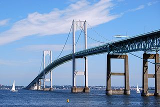
The Claiborne Pell Bridge, commonly known as the Newport Bridge, is a suspension bridge operated by the Rhode Island Turnpike and Bridge Authority that spans the East Passage of the Narragansett Bay in Rhode Island. The bridge, part of RI 138, connects the city of Newport on Aquidneck Island and the Town of Jamestown on Conanicut Island, and is named for longtime Rhode Island U.S. senator Claiborne Pell who lived in Newport. The Pell Bridge is in turn connected to the mainland by the Jamestown Verrazzano Bridge.

Open road tolling (ORT), also called all-electronic tolling, cashless tolling, or free-flow tolling, is the collection of tolls on toll roads without the use of toll booths. An electronic toll collection system is usually used instead. The major advantage to ORT is that users are able to drive through the toll plaza at highway speeds without having to slow down to pay the toll. In some installations, ORT may also reduce congestion at the plazas by allowing more vehicles per hour/per lane.
State Road 874 (SR 874), named the South Miami Dade Don Shula Expressway for its length, is a controlled-access toll road in southern Miami-Dade County, Florida. It extends 7 miles (11 km) northeast from the Homestead Extension of Florida's Turnpike (HEFT) in southwestern Kendall to SR 826 in Glenvar Heights, allowing traffic from the far south of Miami-Dade County and the Florida Keys to move to more central regions of metropolitan Miami and vice versa, bypassing communities along US 1, while also permitting local access to the Kendall district. The road, named in honor of the long-serving coach of the Miami Dolphins NFL team, is maintained and tolled by the Miami-Dade Expressway Authority (MDX). Contrary to the numbering plan of Florida State Roads, SR 874 is signed north–south.

The Dallas North Tollway is a 30.2-mile (49 km) controlled-access toll road operated by the North Texas Tollway Authority (NTTA), which runs from Interstate 35E near downtown Dallas, Texas (USA), to U.S. Highway 380, in Frisco, Texas.
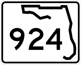
State Road 924 (SR 924) is an 8.5-mile (13.7 km) east–west highway connecting I-75 and SR 826 in Hialeah and SR 909 in North Miami. The westernmost 4.85 miles, named Gratigny Parkway, is a controlled-access toll road maintained by the Miami-Dade Expressway Authority ; the easternmost 3.6 miles (5.8 km) is a surface street also known as Gratigny Road. Despite its relatively short length, SR 924 is a major east–west artery in northern Miami-Dade County.

The Dolphin East-West Expressway is a 15.4-mile (24.8 km) freeway, with the westernmost 14 miles (23 km) as an all-electronic tollway signed as State Road 836, and the easternmost 1.292 miles (2.079 km) between Interstate 95 (I-95) and SR A1A cosigned as Interstate 395 (I-395).
The Pinellas Bayway System is a series of bridges on two state roads in Pinellas County, Florida. It is a toll road complex maintained and operated by the Florida Department of Transportation. It also is compatible with the SunPass ETC system currently in use on all other FDOT-owned toll roads. The Pinellas Bayway consists of:

U.S. Route 278 (US 278) is a 146.130-mile (235.173 km) east–west United States highway that traverses through the South Carolina Lowcountry, from North Augusta to Hilton Head Island.
The Southern Evacuation Lifeline (SELL) is a proposed 28-mile (45 km) limited-access highway in Horry County, South Carolina, in the United States. The project is currently underfunded, expecting to cost around $600 million, and issues with the route itself still remain, as it would travel directly next to several wildlife preserves.

