Katowice Voivodeship was a unit of administrative division and local government in Poland in the years 1975–1998, superseded by the Silesian Voivodeship. Its capital city was Katowice.

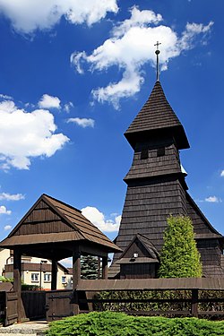
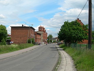
Czerwionka-Leszczyny is a town in Silesia in southern Poland, on the Bierawka River, located on Silesian Highlands, about 50 km (31 mi) north of the Silesian Beskids. It is an outer suburb of Upper Silesian Metropolis, with a population of over 3 million, and a suburb of Rybnik, both making Silesian metropolitan area with a population of 4,676,983 people.
Rybnik Coal Area is an industrial region in southern Poland. It is located in the Silesian Voivodeship, in a basin between the Vistula and Oder rivers, sited on the Rybnik Plateau between Katowice to the north and Ostrava on the south-west. Part a Silesian metropolitan area populated by 5,294,000 people and Silesian metropolitan region populated by about 7 million. According to scientific description by Paweł Swianiewicz and Urszula Klimska this area have 507,000 people, according to European Spatial Planning Observation Network - 634,000 people. Area: about 1,300 km².
Gmina Pilchowice is a rural gmina in Gliwice County, Silesian Voivodeship, in southern Poland. Its seat is the village of Pilchowice, which lies approximately 11 kilometres (7 mi) south-west of Gliwice and 32 km (20 mi) west of the regional capital Katowice.
Gmina Ornontowice is a rural gmina in Mikołów County, Silesian Voivodeship, in southern Poland. Its seat is the village of Ornontowice, which lies approximately 10 kilometres (6 mi) west of Mikołów and 19 km (12 mi) south-west of the regional capital Katowice.
Rudy Landscape Park is a protected area in southern Poland, established in 1993, covering an area of 493.87 square kilometres (190.68 sq mi).

Stare Leszczyny is a village in the administrative district of Gmina Jeżów, within Brzeziny County, Łódź Voivodeship, in central Poland. It lies approximately 8 kilometres (5 mi) south-west of Jeżów, 10 km (6 mi) east of Brzeziny, and 29 km (18 mi) east of the regional capital Łódź.
Bełk is a village in the administrative district of Gmina Czerwionka-Leszczyny, within Rybnik County, Silesian Voivodeship, in southern Poland. It lies approximately 7 kilometres (4 mi) south of Czerwionka-Leszczyny, 13 km (8 mi) north-east of Rybnik, and 25 km (16 mi) south-west of the regional capital Katowice.
Przegędza is a village in the administrative district of Gmina Czerwionka-Leszczyny, within Rybnik County, Silesian Voivodeship, in southern Poland. It lies approximately 9 kilometres (6 mi) south-west of Czerwionka-Leszczyny, 8 km (5 mi) north-east of Rybnik, and 31 km (19 mi) south-west of the regional capital Katowice.

Stanowice is a village in the administrative district of Gmina Czerwionka-Leszczyny, within Rybnik County, Silesian Voivodeship, in southern Poland. It lies approximately 6 kilometres (4 mi) south of Czerwionka-Leszczyny, 11 km (7 mi) north-east of Rybnik, and 27 km (17 mi) south-west of the regional capital Katowice.

Szczejkowice is a village in the administrative district of Gmina Czerwionka-Leszczyny, within Rybnik County, Silesian Voivodeship, in southern Poland. It lies approximately 10 kilometres (6 mi) south of Czerwionka-Leszczyny, 10 km (6 mi) east of Rybnik, and 29 km (18 mi) south-west of the regional capital Katowice.
Piece is a village in the administrative district of Gmina Gaszowice, within Rybnik County, Silesian Voivodeship, in southern Poland. It lies approximately 2 kilometres (1 mi) south of Gaszowice, 9 km (6 mi) west of Rybnik, and 45 km (28 mi) south-west of the regional capital Katowice.
Szczerbice is a village in the administrative district of Gmina Gaszowice, within Rybnik County, Silesian Voivodeship, in southern Poland. It lies approximately 1 kilometre (1 mi) east of Gaszowice, 9 km (6 mi) west of Rybnik, and 44 km (27 mi) west of the regional capital Katowice.
Sumina is a village in the administrative district of Gmina Lyski, within Rybnik County, Silesian Voivodeship, in southern Poland. It lies approximately 11 kilometres (7 mi) west of Rybnik and 45 km (28 mi) west of the regional capital Katowice.
Michałkowice is a settlement in the administrative district of Gmina Świerklany, within Rybnik County, Silesian Voivodeship, in southern Poland. It is part of the village of Jankowice Rybnickie. It lies approximately 2 kilometres (1 mi) east of Jankowice Rybnickie, 6 km (4 mi) south of Rybnik, and 40 km (25 mi) south-west of the regional capital Katowice.

Dębieńsko is a dzielnica (district) of Czerwionka-Leszczyny, Silesian Voivodeship, southern Poland. It was an independent village, but became administratively part of Leszczyny in 1977, renamed to Czerwionka-Leszczyny in 1992. It has an area of 15,01 km2.
Czuchów is a dzielnica (district) of Czerwionka-Leszczyny, Silesian Voivodeship, southern Poland. It was an independent village, but became administratively part of Leszczyny in 1955, renamed to Czerwionka-Leszczyny in 1992. It has an area of 9,07 km2.
Książenice is a village in the administrative district of Gmina Czerwionka-Leszczyny, within Rybnik County, Silesian Voivodeship, in southern Poland.