Palpa Palpa | |
---|---|
Town | |
Coordinates: 14°32′2.16″S75°11′7.74″W / 14.5339333°S 75.1854833°W | |
Country | Peru |
Region | Ica |
Province | Palpa |
District | Palpa |
Demonym | Palpena(o) |
City Established | December 27, 1963 |
Government | |
• Mayor | Jorge Pacheco Martinez |
Elevation | 347 m (1,138 ft) |
Time zone | UTC-5 (PET) |
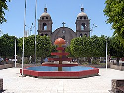
Palpa is a town in southern Peru, capital of the province of Palpa in the Ica region.
As the capital of the Palpa Province, the area is rich in archeological sites. Some have been around since the Archaic Period all the way up to the Incan Empire's decline in the Late Intermediate Period. These sites include: Pernil Alto; Huayuri; Pinchago Bajo and Pinchago Alto; Mollake Chico; PAP-294; PAP-365; PAP-64A and PAP-64B; Juaranga; Los Molinos; Estaqueria; La Muña; El Arenal; Chillo; Parasmarca; and PAP-379. Sites with the name Alto refer to a higher portion of a site, while the Bajo refers to a lower region of it. Each of these sites includes artifacts, such as ceramic pieces, that date the sites themselves through the layers, as well as identify the civilizations that occupied the sites. [1] Most of the sites are close to the town, with it being centrally located between them. Despite the central location, some of these sites are harder to reach based on their physical location, and the ravines worn into the mountains by rivers over time. As a result, new methods of exploration had to be introduced and developed, including 3D Modeling. [2]
Climate data for Palpa (elevation 340 m (1,120 ft), 1991–2020 normals) | |||||||||||||
---|---|---|---|---|---|---|---|---|---|---|---|---|---|
Month | Jan | Feb | Mar | Apr | May | Jun | Jul | Aug | Sep | Oct | Nov | Dec | Year |
Average high °C (°F) | 34.2 (93.6) | 34.7 (94.5) | 34.8 (94.6) | 33.4 (92.1) | 31.1 (88.0) | 28.3 (82.9) | 27.5 (81.5) | 28.6 (83.5) | 30.4 (86.7) | 31.7 (89.1) | 32.6 (90.7) | 33.6 (92.5) | 31.7 (89.1) |
Average low °C (°F) | 19.2 (66.6) | 19.9 (67.8) | 18.9 (66.0) | 16.3 (61.3) | 12.4 (54.3) | 9.9 (49.8) | 8.2 (46.8) | 8.2 (46.8) | 9.8 (49.6) | 11.8 (53.2) | 13.2 (55.8) | 16.6 (61.9) | 13.7 (56.7) |
Average precipitation mm (inches) | 2.7 (0.11) | 1.7 (0.07) | 0.7 (0.03) | 0.1 (0.00) | 0.1 (0.00) | 0.1 (0.00) | 0.1 (0.00) | 0.1 (0.00) | 0.1 (0.00) | 0.1 (0.00) | 0.0 (0.0) | 0.2 (0.01) | 6 (0.22) |
Source: National Meteorology and Hydrology Service of Peru [3] |
Ayacucho is the capital city of Ayacucho Region and of Huamanga Province, Ayacucho Region, Peru.
Ica is a department and region of Peru. It borders the Pacific Ocean on the west; the Lima Region on the north; the Huancavelica and Ayacucho regions on the east; and the Arequipa Region on the south. Its capital is the city of Ica.
Palpa may refer to:
Concepción Province is one of nine provinces in the Junín Region in central Peru. Its capital is Concepción.
Chanchamayo or Chanchamayu is a province in northern Junín Region, in central Peru.
The Pachacámac District is one of 43 districts of the Lima Province in Peru. The capital of the district is the village of Pachacámac. Its main asset is the archaeological Inca site Pachacámac.
Chupaca Province, located in Central Peru, is one of the nine provinces that compose the Junín Region, bordering to the north with the Concepción Province, to the east with the Huancayo Province, to the south with the Huancavelica Region, and to the west with the Lima Region. The province has a population of approximately 57,000 inhabitants, and the capital is Chupaca.
The Mato District is one of 10 districts of the Huaylas Province in the Ancash Region of Peru. The capital of the district is the village of Villa Sucre.
The Casma River, which upstream is called Río Grande, is a river that crosses northern Casma province in the Ancash Region of Peru. It originates in the Black Mountain Range and drains into the Pacific Ocean. Major tributaries include the Sechín River (right).
Mojeque, or Pampa de las Llamas-Moxeke, is a large archaeological site located in the Casma Province of Ancash Region in northern Peru. Archaeologists believe it functioned as a temple or religious structure. It contains two large mounds, many smaller mounds, and multiple human figures and heads believes to depict deities or divine rulers. Large crowds would gather at this site to observe and participate in rituals or ceremonies associated with the mounds. It is only one of the large sites of the Casma/Sechin culture in the Casma and Sechin River valleys. The others are Cerro Sechin, Sechin Alto, and Sechin Bajo. The Sechin River is a tributary of the Casma River.
The Palpa Province is the smallest of five provinces of the Ica Region of Peru and the only landlocked province of the region. The capital of the province is the city of Palpa.
Cerro Sechín is an archaeological site in Casma Province of Ancash Region in northern Peru. Dating to 1600 BC, the site was discovered by Peruvian archaeologists Julio C. Tello and Toribio Mejía Xesspe on July 1, 1937. Tello believed it was the capital of an entire culture, now known as the Casma/Sechin culture or Sechin complex. Notable features include megalithic architecture with carved figures in bas-relief, which graphically dramatize human sacrifices. Cerro Sechín is situated within the Sechin Alto Complex, as are Sechin Bajo, and Taukachi-Konkan. There is a small on-site museum. The slabs at Cerro Sechin may represent the central Andes' oldest known monumental sculpture.
Palpa District is one of five districts of the province Palpa in Peru.
Río Grande District is one of five districts of the province Palpa in Peru. The archaeological site of Pernil Alto is located in the district.
Santa Cruz District is one of five districts of the province Palpa in Peru. A large Pre-Comlumbian archaeological site called the Lost City of Huayuri is located in the district.
Boquete District is a district (distrito) of Chiriquí Province in Panama located on the North of the Chiriqui Province, in the western side of the country. The population according to the 2010 census was 22,435. The district covers a total area of 488.48 square kilometres (188.60 sq mi).
Sechin Alto is a massive architectural complex in Peru belonging to the Early Formative period. It is located in the Casma Province, the Ancash Region, on the left bank of the Sechín River, east of the town of the same name. Other important archaeological sites such as Cerro Sechin and Sechin Bajo are located nearby.
Las Haldas or Las Aldas is a large archaeological complex from before and during the initial ceramic period of Peru. Las Haldas is located on the Pacific coast approximately 300 kilometres (190 mi) north of Lima and about 20 kilometres (12 mi) south of the Casma river valley, noted for the extensive ruins of the Casma–Sechin culture. For most of its history Las Haldas, a coastal community, coexisted with the inland agricultural communities in the Casma River Valley.
The Casma–Sechin culture of Peru refers to the large concentration of pre-historic ruins in the valleys of the Casma River and its tributary the Sechin River and along the nearby coast of the Pacific Ocean. The ruins include major archaeological sites such as Sechin Bajo, Sechin Alto, Cerro Sechin, Mojeque, Chankillo, and Taukachi-Konkan, as well as other smaller sites. Most of these inland sites are found in the river valleys about 20 kilometres (12 mi) distant from the ocean. The seaside sites of Huaynuná and Las Haldas are found about 20 kilometres (12 mi) north and south of the mouth of the Casma River on the coast.
14°32′02.16″S75°11′07.74″W / 14.5339333°S 75.1854833°W