
The Andes, Andes Mountains or Andean Mountain Range are the longest continental mountain range in the world, forming a continuous highland along the western edge of South America. The range is 8,900 km (5,530 mi) long, 200 to 700 km wide, and has an average height of about 4,000 m (13,123 ft). The Andes extend from north to south through seven South American countries: Venezuela, Colombia, Ecuador, Peru, Bolivia, Chile and Argentina.

The Inca road system was the most extensive and advanced transportation system in pre-Columbian South America. It was about 40,000 kilometres (25,000 mi) long. The construction of the roads required a large expenditure of time and effort.

Atahualpa, also Atawallpa (Quechua), Atabalica, Atahuallpa, Atabalipa, was the last effective Incan emperor before his capture and execution during the Spanish conquest.

Imbabura is a province located in the Andes of northern Ecuador. The capital is Ibarra. The people of the province speak Spanish, and a large portion of the population also speaks the Imbaburan Kichwa variety of the Quechua language.
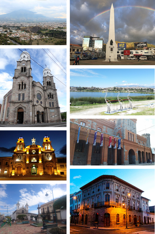
Ibarra is a city in northern Ecuador and the capital of the Imbabura Province. It lies at the foot of the Imbabura Volcano and on the left bank of the Tahuando river. It is located about 70 kilometres (43 mi) northeast of Ecuador's capital Quito.
Pambamarca is an eroded stratovolcano in the Central Cordillera of the northern Ecuadorian Andes in Pichincha Province. it is 25 miles (40 km) northeast of Quito. The summit is at an elevation of 4,062 metres (13,327 ft).

Cayambe Coca National Park is a national park in Ecuador located along the Equator about 38 km (24 mi) from Quito. The park encompasses an area of 4,031.03 km2.

Pukara is a defensive hilltop site or fortification built by the prehispanic and historic inhabitants of the central Andean area. In some cases, these sites acted as temporary fortified refuges during periods of increased conflict, while other sites show evidence for permanent occupation. Emerging as a major site type during the Late Intermediate Period, the pukara form was adopted in some areas by the Inca military in contested borderlands of the Inca Empire. The Spanish also referred to the Mapuche earthen forts built during the Arauco War in the 16th and 17th centuries by this term.

El Quinche is a city of Ecuador, in the Pichincha Province, about 22 km (14 mi) in a straight line distance northeast of the city of Quito. The city, administratively a rural parish of the canton of Quito, is located in the valley of the headwaters of the Guayllabamba River, to the west of Pambamarca. It borders Cayambe Canton to the northeast.

The Andean civilizations were South American complex societies of many indigenous people. They stretched down the spine of the Andes for 4,000 km (2,500 mi) from southern Colombia, to Ecuador and Peru, including the deserts of coastal Peru, to north Chile and northwest Argentina. Archaeologists believe that Andean civilizations first developed on the narrow coastal plain of the Pacific Ocean. The Caral or Norte Chico civilization of coastal Peru is the oldest known civilization in the Americas, dating back to 3500 BCE. Andean civilization is one of the six "pristine" civilizations of the world, created independently and without influence by other civilizations.

The Otavalos are an indigenous people native to the Andean mountains of Imbabura Province in northern Ecuador. The Otavalos also inhabit the city of Otavalo in that province. Commerce and handcrafts are among the principal economic activities of the Otavalos, who enjoy a higher standard of living than most indigenous groups in Ecuador and many mestizos of their area.

Monte Catequilla is an archaeological site in the Pomasqui Valley of Ecuador. Located in the Parish of San Antonio of Quito Canton in Pichincha Province, it has an elevation of 2,638 metres (8,655 ft) and is located on a mountaintop about 300 metres (980 ft) above valleys on either side. Attributed to the Pre-Columbian era Quitu-Cara culture, it was presumably used as an astronomical observatory even before the arrival of the Incas, and is the only prehispanic site in the Americas that is located precisely at the Earth's Equator.
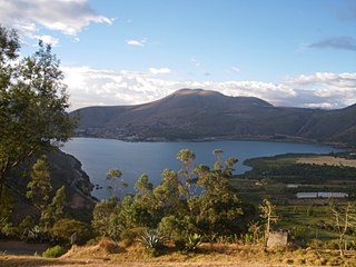
Yawarkucha or Yawar Kucha, Hispanicized spellings Yaguarcocha, Yahuarcocha) is a lake in Ecuador located in the eastern outskirts of the city of Ibarra in Imbabura Province, Ibarra Canton. The lake is about 2 kilometres (1.2 mi) long and wide and has an elevation of 2,190 metres (7,190 ft) above sea level. The lake was formed from glacial meltwater about 10,000 BCE.

Cojitambo is an Inca and pre-Inca archaeological ruin, a popular rock climbing site, and a small village west of Azogues, capital of Canar province of Ecuador.
Cochasquí is one of the most extensive and most important complexes of pre-Columbian and pre-Inca Empire ruins in northern Ecuador. The site lies some 30 kilometres (19 mi) northeast of Quito in Pedro Moncayo Canton in Pichincha Province at 3,040 metres (9,970 ft) above sea level.

Huánuco Pampa, Huánuco Marka or Huánuco Viejo, or Wanuku Pampa is a large archaeological site in Peru in the Huánuco Region, Dos de Mayo Province, La Unión District. The ruins of the city lie on a plateau above the Urqumayu or Vizcarra River in the central Andes. The Incas administered their large empire through a small number of administrative centers, such as Huánuco Pampa. The administrative centers were linked by the extensive Inca road system. The most important of the roads, the Qhapaq Ñan, which ran from Cusco to Quito, passed through Huánuco Pampa. The Inca authorities in Huánuco ruled at least five, and perhaps more, ethnic groups. The city is situated on an important commercial trade route and sits on top of a plateau with ravines on all sides in order to allow easy defense of the city. During the Spanish conquest of the Incas, Huánuco Pampa was briefly occupied by Gomez de Alvarado, who founded a Spanish city there but it was quickly moved because of the harsh climate and Inca raids of Illa Tupac, one of the captains of Manco Inca.
Oroncota or Huruncuta was an Inca provincial center or capital on the border of Chuquisaca and Potosí Departments of Bolivia. Oroncota was captured by the Incas during the reign of Topa Inca Yupanqui (1471-1493) and served as a defensive outpost protecting the eastern frontiers of the Inca empire. The primary residents of the Oroncota area for more than 1,500 years have been the Yampara people. In the 16th century, during the last years of the Inca Empire and the early Spanish Empire, Oroncota and its region were under heavy attack by the Ava Guarani people (Chiriguanos) ethnic group who eventually gained control of the area.
The Inca-Caranqui archaeological site is located in the village of Caranqui on the southern outskirts of the city of Ibarra, Ecuador. The ruin is located in a fertile valley at an elevation of 2,299 metres (7,543 ft). The region around Caranqui, extending into the present day country of Colombia, was the northernmost outpost of the Inca Empire and the last to be added to the empire before the Spanish conquest of 1533. The archaeological region is also called the Pais Caranqui.
Rumicucho or Pucara de Rumicucho is an archaeological site of the Inca Empire in the parroquia of San Antonio de Pichincha, in Quito Canton, Pichincha Province. Ecuador. Rumicucho is a pucara located 23 kilometres (14 mi) in a straight-line distance north of the city of Quito at an elevation of 2,401 metres (7,877 ft). Rumicucho in the Quechua language means "stone corner", perhaps referring to its strategic location between the territory of the Yumbo people to the east and the chiefdoms of the Pais Caranqui to the north.

The Eastern Cordillera Real montane forests (NT0121) is an ecoregion in the eastern range of the Andes of southern Colombia, Ecuador and northern Peru. The ecoregion covers the eastern slopes of the Andes, and includes montane forest that rises from the Amazonian rain forest, with cloud forest and elfin forest at higher elevations. It is rich in species, including many endemics. It is threatened by logging and conversion for pasturage and subsistence agriculture.

