
Krakatoa, also transcribed Krakatau, is a caldera in the Sunda Strait between the islands of Java and Sumatra in the Indonesian province of Lampung. The caldera is part of a volcanic island group comprising four islands. Two of them are known as Lang and Verlaten; another, Rakata, is the only remnant of an island mostly destroyed by an eruption in 1883 which created the caldera.

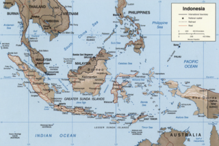
The Sunda Strait is the strait between the Indonesian islands of Java and Sumatra. It connects the Java Sea with the Indian Ocean.
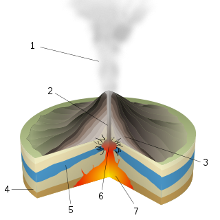
A phreatic eruption, also called a phreatic explosion, ultravulcanian eruption or steam-blast eruption, occurs when magma heats ground water or surface water. The extreme temperature of the magma causes near-instantaneous evaporation of water to steam, resulting in an explosion of steam, water, ash, rock, and volcanic bombs. At Mount St. Helens in Washington state, hundreds of steam explosions preceded the 1980 Plinian eruption of the volcano. A less intense geothermal event may result in a mud volcano.
The Sunda Arc is a volcanic arc that produced the volcanoes that form the topographic spine of the islands of Sumatra, Nusa Tenggara, Java, the Sunda Strait, and the Lesser Sunda Islands. The Sunda Arc begins at Sumatra and ends at Flores, and is adjacent to the Banda Arc. The Sunda Arc is formed via the subduction of the Indo-Australian Plate beneath the Sunda and Burma plates at a velocity of 63–70 mm/year.
Rakata, also called Greater Krakatau, is a partially collapsed and uninhabited stratovolcano on the Indonesian island of Krakatoa in the Sunda Strait between the islands of Sumatra and Java. Standing 813 m (2,667 ft) tall, it was the largest and southernmost of three volcanoes that formed the island Krakatoa and the only one not totally destroyed in the 1883 eruption. Rakata is the last remnant of the original island prior to its destruction. However, Rakata did lose its northern half in that eruption, leaving just its southern half. The exposed cliff is quite striking visually, partially of a large exposed dike terminating in a large lenticular extrusion at the middle of the almost vertical cliff. The feature has been called "the Eye of Krakatoa."

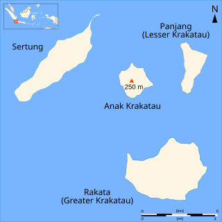
Anak Krakatau is a volcanic island in Indonesia. On 29 December 1927, Anak Krakatau first emerged from the caldera formed in 1883 by the explosive volcanic eruption that destroyed the island of Krakatoa. There has been sporadic eruptive activity at the site since the late 20th century, culminating in a large underwater collapse of the volcano, which caused a deadly tsunami in December 2018. There has been subsequent activity since. Owing to its young age the island is one of several in the area that are of interest to, and the subject of extensive study by volcanologists.

Krakatoa, East of Java is a 1968 American disaster film starring Maximilian Schell and Brian Keith. During the 1970s, the film was re-released under the title Volcano. The story is loosely based on events surrounding the 1883 eruption of the volcano on the island of Krakatoa, with the characters engaged in the recovery of a cargo of pearls from a shipwreck perilously close to the volcano. The film was nominated for the Academy Award for Best Special Visual Effects.

Krakatoa: The Last Days is a BBC Television docudrama that premiered on 7 May 2006 on BBC One. The program is based upon four eyewitness accounts of the 1883 eruption of Krakatoa, an active stratovolcano between the islands of Sumatra and Java, present day Indonesia.
Lang Island lies in the Sunda Strait, between Java and Sumatra, in Indonesia. It is one of the Krakatoa Archipelago, above the famous Krakatoa volcano. Lang suffered only slightly in the 1883 eruption of Krakatoa; it actually grew in area from massive pumice fall, although most of the additional area washed away within several years.
Perboewatan was one of the three main volcanic cones on the island of Krakatoa, in the Sunda Strait, in Indonesia. It was the lowest and northernmost of the cones. Perboewatan was completely destroyed during the 1883 eruption; the caldera is approximately 250 metres (820 ft) deep at its former location.
Danan was one of the three volcanic cones on the island of Krakatoa, in the Sunda Strait, in Indonesia. It stood 450 metres (1,480 ft), lay in the central area of the island, and may have been a twin volcano. Danan was almost entirely destroyed in the 1883 eruption of Krakatoa; only a rocky islet named Bootsmansrots remains of it.
Verlaten Island is a volcanic island. It may have been created in the 535 AD eruption of Krakatoa. It is located in the Sunda Strait in Indonesia, between Java and Sumatra. It is part of the Krakatoa Archipelago, above the famous Krakatoa volcano. Other than some minor collapse in the southeast, Verlaten suffered little damage in the 1883 eruption. Instead, it grew almost three times in area due to pumice fall, although most of the gain was quickly eroded away.

Anyer, also known as Anjer or Angier, is a coastal town in Banten, formerly West Java, Indonesia, 82 miles (100 km) west of Jakarta and 15 kilometers (9 mi) south of Merak. A significant coastal town late 18th century, Anyer faces the Sunda Strait.
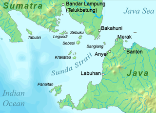
Sebesi is an Indonesian island in the Sunda Strait, between Java and Sumatra, and part of the province of Lampung. It rises to a height of 844 metres (2,769 ft) and lies about 12 kilometres (7.5 mi) north of the Krakatoa Archipelago; it is the closest large island to Krakatoa, about the same area and height as the remnant of Rakata. Like Krakatoa, it too is volcanic, although no dated eruptions are known. Unlike the Krakatoa Archipelago, Sebesi has permanent streams and is inhabited. Habitation is concentrated most heavily on the northern and eastern coasts of the island.
Gouverneur Generaal Loudon was a mail steamer and excursion vessel which survived the 1883 eruption of Krakatoa.

Sebuku is an island in the Sunda Strait between Java and Sumatra. It is one of the larger islands in the strait and lies just 2.5 km (1.6 mi) to the north of Sebesi and 2.3 kilometres (1.4 mi) south of Sumatra. It is administratively part of South Lampung Regency, Lampung.
Krakatoa, in the Sunda Strait in Indonesia, has attracted a significant literature and media response to the 1883 eruption and subsequent events in the vicinity.

The 1883 eruption of Krakatoa in the Sunda Strait occurred from 20 May until 21 October 1883, peaking in the late morning of 27 August when over 70% of the island of Krakatoa and its surrounding archipelago were destroyed as it collapsed into a caldera.

The Krakatoa Archipelago is a small uninhabited archipelago of volcanic islands formed by the Krakatoa stratovolcano located in the Sunda Strait, nestled between the much larger islands of Java and Sumatra. As of 2018, the archipelago consists of four main islands: Verlaten, Lang, Rakata, and the currently volcanically active Anak Krakatoa. Together, the islands are a part of the Indonesian island arc system, created by the northeastward subduction of the Indo-Australian Plate. As part of a dynamic volcanic system, the islands have been continuously reshaped throughout recorded history, most notably in the 1883 eruption of Krakatoa.
