
Rivesville is a town and former coal town in Marion County, West Virginia, United States. The population was 830 at the 2020 census.

The Northern Panhandle is the northern of the two panhandles in the U.S. state of West Virginia. It is a culturally and geographically distinct region of the state. It is the state's northernmost extension, bounded by Ohio and the Ohio River on the north and west and the state of Pennsylvania on the east. Its unusual configuration is the result of the Revolutionary-era claims of Virginia's former Yohogania County boundary lying along the Ohio River, conflicting with interpretations of the Colony of Pennsylvania's royal charter. The conflict was settled by compromise in the 1780s.

The Coal Region is a region of Northeastern Pennsylvania. It is known for being home to the largest known deposits of anthracite coal in the world with an estimated reserve of seven billion short tons.
Drift mining is either the mining of an ore deposit by underground methods, or the working of coal seams accessed by adits driven into the surface outcrop of the coal bed. A drift mine is an underground mine in which the entry or access is above water level and generally on the slope of a hill, driven horizontally into the ore seam.

Rennerdale is an unincorporated community and census-designated place in Collier Township, Allegheny County, Pennsylvania, United States, about 9 miles (14 km) southwest of Pittsburgh. As of the 2020 census it had a population of 1,103.
The Connellsville Coalfield is located in Fayette County and Westmoreland County, Pennsylvania, between the city of Latrobe and the small borough of Smithfield. It is sometimes known as the Connellsville Coke Field. This is because the section of the Pittsburgh coal seam here was famous as one of the finest metallurgical coals in the world. It is locally known as the Connellsville coal seam, but is a portion of the Pittsburgh seam.
The Winding Gulf Coalfield is located in western Raleigh County and eastern Wyoming County, in southern West Virginia. It is named after the Winding Gulf stream, a tributary of the Guyandotte River. In the early 20th century, it was promoted as the "Billion Dollar Coalfield".

The New River Coalfield is located in northeastern Raleigh County and southern Fayette County, West Virginia. Commercial mining of coal began in the 1870s and thrived into the 20th century. The coal in this field is a low volatile coal, known as "smokeless" coals. The seams of coal that have been mined include Sewell, Fire Creek, and Beckley. This is very high quality bituminous coal rated at approximately 15,000 BTU (16,000 kJ). The New River coalfield is named after the north flowing New River. Over 60 coal towns were once located there, supported by independent commercial districts at Beckley, Oak Hill, Mount Hope, and Fayetteville. By the 21st century many coal camps had partially or completely returned to nature. These company towns were located along Dunloup (Loup) Creek, Laurel Creek, White Oak Creek, lower Piney Creek, and, of course, the New River. The mainline of the Chesapeake and Ohio Railway ran right through the center of this coalfield, with spurs branching off in many directions, and rail yards were maintained at Quinnimont, Raleigh, and Thurmond, WV. The Virginian Railway's main line also passed through the western side of the field as well. Companies such as the New River Company, New River & Pocahontas Consolidated Coal Co., and Mary Frances Coal Co. were the largest operators in the New River Coalfield, but there were many smaller ones as well. These companies recruited native born whites, immigrants from Southern and Eastern Europe, and African-Americans from the South to work in their coal mines and railroads. The mines began to close down after World War II and today there are very few active coal mines in the field. The New River Gorge is now the domain of the National Park Service as the New River Gorge National Park and Preserve, and they have done what their budget allows to preserve the coal heritage of the area.

Pocahontas Coalfield, which is also known as the Flat Top-Pocahontas Coalfield, is located in Mercer County/McDowell County, West Virginia and Tazewell County, Virginia. The earliest mining of coal in the coalfield was in Pocahontas, Virginia in 1883 at Pocahontas Mine No. 1, now on the National Register of Historic Places.
The Logan Coalfield is a coalfield located in Logan County and Wyoming County of southern West Virginia, in the Appalachia region of the eastern United States.
Eckhart Mines is an unincorporated community and census-designated place (CDP) in Allegany County, Maryland, United States. As of the 2010 census it had a population of 932.
The Clearfield Coalfield is a bituminous coal mining area in Clearfield County, Pennsylvania, United States. The coal seams are found in most parts of Clearfield County, with the notable exception of the northern part of the county.
The South Yorkshire Coalfield is so named from its position within Yorkshire. It covers most of South Yorkshire, West Yorkshire and a small part of North Yorkshire. The exposed coalfield outcrops in the Pennine foothills and dips under Permian rocks in the east. Its most famous coal seam is the Barnsley Bed. Coal has been mined from shallow seams and outcrops since medieval times and possibly earlier.
The Pittsburgh Coalfield is the largest of the Western Pennsylvania coalfields. It includes all or part of Allegheny, Fayette, Greene, Washington, and Westmoreland Counties in Pennsylvania. Coal has been mined in Pittsburgh since the 18th century. U.S. Steel and Bethlehem Steel owned Karen, Maple Creek, and Ellsworth mines. It is not possible to define sharp geographical boundaries for this district for none such exist or are reported differently. The largest company in this field was the Pittsburgh Coal Company, which later became CONSOL Energy. It is bordered on the west by the state of West Virginia, on the south by Panhandle Coalfield and Klondike Coalfield, on the East by Irwin Gas Coalfield, on the North by the Freeport Coalfield and at least one other coalfield. The Darr Mine Disaster occurred in this coalfield in 1907.

Mount Washington Transit Tunnel is an important public transportation link in Pittsburgh, Pennsylvania, United States. The 3,492-foot (1,064 m) tunnel connects Station Square to South Hills Junction, and is used only by Pittsburgh Light Rail cars and buses of the Port Authority of Allegheny County. The tunnel changes 204.54 feet in elevation from its north portal at 750.36 feet above sea level to its south portal at 954.90 feet above sea level, resulting in a grade of 5.86%. With the elimination of bus service in the Downtown Seattle Transit Tunnel in 2019, the Mount Washington Transit Tunnel is the only tunnel in the United States shared by bus and rail services.
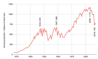
The history of coal mining in the United States starts with the first commercial use in 1701, within the Manakin-Sabot area of Richmond, Virginia. Coal was the dominant power source in the late 1800s and early 1900s, and although in rapid decline it remains a significant source of energy in 2023.
The Naomi Mine explosion occurred on December 1, 1907, in the Naomi Mine, approximately 2 miles (3.2 km) from Fayette City, Pennsylvania. The incident resulted in the deaths of at least 35 miners and left no survivors.
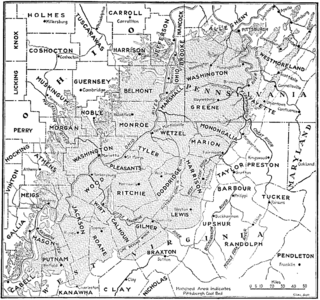
The Pittsburgh Coal Seam is the thickest and most extensive coal bed in the Appalachian Basin; hence, it is the most economically important coal bed in the eastern United States. The Upper Pennsylvanian Pittsburgh coal bed of the Monongahela Group is extensive and continuous, extending over 11,000 mi2 through 53 counties. It extends from Allegany County, Maryland to Belmont County, Ohio and from Allegheny County, Pennsylvania southwest to Putnam County, West Virginia.
The Meadow Branch Coalfield is a coalfield located in the Eastern Panhandle of West Virginia along the Berkeley and Morgan county lines.

The Coalbrookdale Coalfield is a coalfield in Shropshire in the English Midlands. It extends from Broseley in the south, northwards to the Boundary Fault which runs northeastwards from the vicinity of The Wrekin past Lilleshall. The former coalfield has been built on by the new town of Telford.