
The Ottawa River is a river in the Canadian provinces of Ontario and Quebec. It is named in honour of the Algonquin word 'to trade', as it was the major trade route of Eastern Canada at the time. For most of its length, it defines the border between these two provinces. It is a major tributary of the St. Lawrence River and the longest river in Quebec.

An alvar is a biological environment based on a limestone plain with thin or no soil and, as a result, sparse grassland vegetation. Often flooded in the spring, and affected by drought in midsummer, alvar support a distinctive group of prairie-like plants. Most alvars occur either in northern Europe or around the Great Lakes in North America. This stressed habitat supports a community of rare plants and animals, including species more commonly found on prairie grasslands. Lichen and mosses are common species. Trees and bushes are absent or severely stunted.

Alfred and Plantagenet is a township in eastern Ontario, Canada, in the United Counties of Prescott and Russell. Located approximately 70 km (43 mi) from downtown Ottawa at the confluence of the Ottawa River and the South Nation River.

The Mississippi River is a tributary of the Ottawa River in Eastern Ontario, Canada which has no relation with the Mississippi River in the United States. It is 200 kilometres (120 mi) in length from its source at Mackavoy Lake, has a drainage area of 4,450 square kilometres (1,720 sq mi), and has a mean discharge of 40 cubic metres per second (1,400 cu ft/s). There are more than 250 lakes in the watershed.

Lanark County is a county located in the Canadian province of Ontario. Its county seat is Perth, which was first settled in 1816. Most European settlements of the county began in 1816, when Drummond, Beckwith and Bathurst townships were named and initially surveyed. The first farm north of the Rideau was cleared and settled somewhat earlier, in 1790. The county took its name from the town of Lanark in Scotland. Nearly all the townships were named after British public and military figures from the era of early settlement.

Wolfe Island is an island at the entrance to the Saint Lawrence River in Lake Ontario near Kingston, Ontario. Wolfe Island is part of Frontenac County, Ontario and the Township of Frontenac Islands. It is the largest of the Thousand Islands. The largest community on the island is Marysville. The island was part of the traditional hunting lands of the Tyendinaga Mohawk people and the original name of the island is Ganounkouesnot. It was called Grand Island. In a proclamation by the Lieutenant Governor of Upper Canada John Graves Simcoe on 16 July 1792, the island was renamed from Grand island to Wolfe island, after British General James Wolfe.

Pottageville is an unincorporated community located in northeastern King Township, in Ontario, Canada. It is near Schomberg. It is named for one of its early settlers, Edward Pottage.

Happy Valley is an unincorporated rural community in King Township, York Regional Municipality, Ontario, Canada.

Petrie Island is an island of parkland and recreational areas situated in the Ottawa River in the eastern part of the city of Ottawa, Ontario, Canada. The island has several nearby islands and the general collection of islands is also called Petrie Island.

Cold Creek Conservation Area, usually Cold Creek, is an ecologically diverse protected Area of Natural and Scientific Interest in south-central Ontario, Canada. The 190-hectare (470-acre) conservation area was opened on 20 June 1962 by Wilf Spooner and the Toronto and Region Conservation Authority. It is located on the western end of King Township, overlapping the Oak Ridges Moraine. The Government of Ontario Ministry of Natural Resources classifies the area as a provincially significant Area of Natural and Scientific Interest for its "provincially or regionally significant representative ecological features". The area was also a site classified for the International Biological Program. The Life Science area, known as Cold Creek Swamp, is composed of a swamp and forest.
An Area of Natural and Scientific Interest is an official designation by the provincial Government of Ontario in Canada applied to contiguous geographical regions within the province that have geological or ecological features which are significantly representative provincially, regionally, or locally. Some sites with this designation were assessed through the International Biological Program between 1964 and 1974. As of 2014, over 1000 sites covering 460,000 hectares (4,600 km2) have been designated in the province.
Matchedash Bay is a bay and Ramsar wetland in Simcoe County in Central Ontario, Canada. It is the "final inland extension of Severn Sound" on Lake Huron's Georgian Bay, and is "situated at the interface between the Saint Lawrence Lowlands and the Canadian Shield ". It exhibits geologically unique features at the junction of the Canadian Shield and southern Ontario limestone. Wetland habitats in Matchedash Bay are varied, and include swamps, fens, cattail marshes, wet meadows and beaver ponds. Other features include "permanent freshwater lakes; upland hardwood forest, agricultural lands, native grass meadows and a unique, coniferous wetland forest".

Minesing Wetlands, previously known as Minesing Swamp, is a Ramsar boreal wetland in central Ontario, Canada stretching from the western periphery of Barrie to Georgian Bay. It was identified and classified through the International Biological Program. It is "the largest and best example of fen bog in southern Ontario", one of the "most diverse undisturbed wetland tracts in Canada" and is a provincially significant Area of Natural and Scientific Interest. The term minesing is of Ojibwe origin and means "island", referring to an island located within Lake Edenvale, which encompassed the present-day wetlands and surrounding areas.
The Uxbridge Forest Kames is a 644-hectare (1,591-acre) provincially significant Earth Science Area of Natural and Scientific Interest in Ontario, Canada. The land is owned and managed by the Toronto and Region Conservation Authority.
The Cheltenham Badlands are located northwest of Toronto, Ontario, on the south east side of Olde Base Line Road, between Creditview and Chinguacousy Roads. The site occupies an area of approximately 0.4 square kilometers and features exposed and highly eroded Queenston Shale. The Cheltenham Badlands are a significant educational site due to the readily visible geologic processes and the red color and the unique topography of the exposed shale makes this a popular tourist site. The site is a Provincial Earth Sciences Area of Natural and Scientific Interest (ANSI) since it is considered as one of the best examples of "badlands topography" in Ontario.
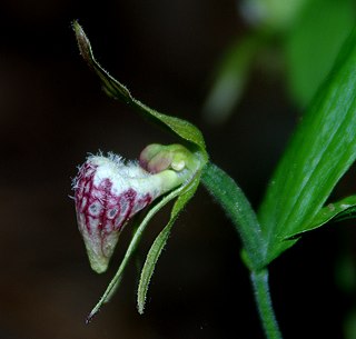
Cypripedium arietinum, the ram's head lady's slipper, is a rare orchid that grows in lightly shaded areas with calcareous soils. It is characteristic of the alvars around the Great Lakes in North America, as well as in New England. In Canada, it is found from Quebec to Saskatchewan, plus an isolated population in Nova Scotia, where it grows on gypsum based soils, 330 km away from the nearest population in Maine.
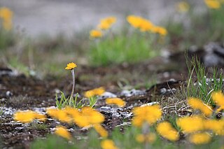
Tetraneuris herbacea is a rare species of flowering plant in the aster family known by the common names eastern fournerved daisy, lakeside daisy, fournerved starflower, and Manitoulin gold. It is native to and endemic to the Great Lakes region in North America, where it is present in Ontario, Ohio, Michigan, and Illinois. It is threatened by habitat destruction and degradation by several forces, including limestone quarrying, recreational activity, fire suppression, and construction. It is a federally listed threatened species of the United States and of Canada.

The White Lake fen is a small wetland on the shore of White Lake in Lanark County, Ontario in Canada. It has been designated both an Area of Natural and Scientific Interest and a Provincially Significant Wetland; it is also listed as a Special Place in Lanark County. Fens are a relatively rare wetland habitat in the region of Lanark County; they can occur on either marble or limestone bedrock. White lake has a granite dome along its north shore, while it spreads over marble bedrock to the south. A number of calcareous fens have developed along the south shore. The largest of these has developed in a long narrow arm of the lake, where it stretches for nearly two kilometers and covers 90 ha.

The Burnt Lands is an alvar between Almonte and Ottawa near Upper Huntley, Ontario, Canada. It probably obtained its name from one of the forest fires that swept the area during early European settlement.
The Mixedwood Plains Ecozone is the Canadian ecozone with the most southern extent, covering all of southwestern Ontario, and parts of central and northeastern Ontario and southern Quebec along the Saint Lawrence River. It was originally dominated by temperate deciduous forest growing mostly on limestone covered by glacial till. It is the smallest ecozone in Canada, but it includes the country's most productive industrial and commercial region, and is home to nearly half of Canada's population, including its two largest cities, Toronto, Ontario and Montreal, Quebec. Hence, little of the original forest cover remains, making protection of the remaining forests a high conservation priority. This ecozone includes two regions described by J.S. Rowe in his classic Forest Regions of Canada: the entire Deciduous Forest Region, and the southern portions of the Great Lakes-St. Lawrence Forest Region. In the province of Ontario, the Ontario Ministry of Natural Resources maps this area as Site Regions 6E and 7E.

