
Thoothukudi is a port city, a municipal corporation, and an industrial city in Thoothukudi district in the Indian state of Tamil Nadu. The city lies on the Coromandel Coast of the Bay of Bengal. Thoothukudi is the capital and headquarters of Thoothukudi district. It is located about 590 kilometres southeast of Chennai, 190 kilometres northeast of Thiruvananthapuram, and 580 kilometres southeast of Bengaluru. According to the Confederation of Indian Industry, Thoothukudi has the second highest Human Development Index in Tamil Nadu, next to Chennai. Thoothukudi City serves as the headquarters of Tamilnad Mercantile Bank Limited, one of the leading private sector banks in India. Major educational establishments in the city include the Government Thoothukudi Medical College, Fisheries College and Research Institute, Tamil Nadu Maritime Academy, V.O. Chidambaram College, Kamaraj College, Anna University, and Government Polytechnic College. The V.O. Chidambaranar Port Authority is one of the major ports in India. Thoothukudi is an emerging energy and industrial hub of South India.

Tirunelveli district is one of the 38 districts of Tamil Nadu state in India. It is the largest district in terms of area with Tirunelveli as its headquarters. The district was formed on 1 September 1790 by the British East India Company, and comprised the present Tirunelveli and Thoothukudi, Tenkasi and parts of Virudhunagar and Ramanathapuram district. As of 2011, the undivided district had a population of 3,077,233.
Thoothukudi District is one of the 38 districts of Tamil Nadu state in southern India. The district was formed by bifurcation of Tirunelveli district on 20 October 1986. Thoothukudi is the district headquarters and largest city of the district. The district is known for fishing as well as pearl cultivation, with an abundance of pearls being found in the seas offshore. Thoothukudi district has many historical sites such as Adichanallur and the ancient trade port of Korkai.
Nazareth is a town in the Thoothukudi district in the Indian state of Tamil Nadu.
Arumuganeri is a panchayat town at Tiruchendur constituency from Thoothukudi district in the state of Tamil Nadu, India.In ancient times, the town was part of the Kuda Nadu division headed by Korkai.
Sathankulam is a panchayat town in Thoothukudi district in the Indian state of Tamil Nadu.
Ottapidaram is a small town in Thoothukudi district and headquarters of Ottapidaram taluk. Ottapidaram is a tourism centre with accessibility to many places in Tamil Nadu. Thoothukudi or Tirunelveli can be easily accessed from anywhere and Ottapidaram is very close to these two places. The great freedom fighter V. O. Chidambaram Pillai called VOC hails from Ottapidaram. VOC is also called as "Kappalottiya Tamizhan" because he launched one of the first shipping companies, Swadeshi Steam Navigation Company which operated ship between Tuticorin and Colombo against the British during the rule in India.

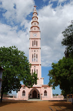
Oyangudi is a small village situated near Nazareth in Thoothukudi District of Tamil Nadu, India. Nazareth is 2.5 km away from Oyangudi. There are about 200 families are living in this village. More than 250 houses are there in this village. It belongs to the Mukkuperi panchayet. A C.S.I Church is located at the center of the village. An E.R.S Church is situated on the west side of main street. There are four streets are there in Oyangudi. They are West Street, East Street, North Street, and South Street. A post office located at the south street. A water tank is located on the east street. A road from Nazareth to Tiruchendur divides North part and South part. In the southern part a railway road is crossing from East to Westwardly from Tiruchendur to Tirunelveli.
Kottaikkadu is a small village in Tuticorin district, belongs to Srivaikundam Taluk and Siruthonda Nallore panchayat.
Avaraikulam is a village in the Tirunelveli district of Tamil Nadu, India. It is located 72 km from Tirunelveli and 20 km from Kanyakumari. Most residents are involved in agrarian activities. The Arulmigu Mutharamman Thirukovil Temple in the village is famous for its Vaigasi Thiruvizha. Avaraikulam is also referred to as 'Asaiyaa Pattinam', meaning 'Immovable Town'.
Tirunelveli City being the district headquarters of Tirunelveli District in the Indian state of Tamil Nadu has a very extensive transport network. Tirunelveli district is a vital tourist destination with lot of religious places, monuments and hill stations. Tirunelveli is also a major junction for transportation around Tirunelveli, Thoothukudi and Kanyakumari Districts.
Thoothukudi is an Industrial City and it has transport connections via road, rail, sea and air. After Chennai, Thoothukudi is the only city in Tamil Nadu to have all four means of transport.
Kavalkinaru is a village panchayat in the Tirunelveli district of Tamil Nadu. It is located 24 km from Nagercoil, 69 km from Tirunelveli, and 99 km from Trivandrum International Airport. The nearest port, Tuticorin Port Trust,, is 111 km from Kavalkinaru. The town, once dependent on agriculture, livestock, stone mining, flower cultivation and the processing of Borassus, is now embracing new technologies and professions. The high tunneling-effect of the Western Ghats has enabled this region to be a major Wind Power generation area for India, with thousands of windmills. There are also the test facilities for ISRO Propulsion Complex, a part of Indian Space Research Organisation (ISRO), on the lower slopes of the Mahendragiri mountain near Kavalkinaru.
Thirumoolanagar is a village with about 175 households and a population of 800 in the Kanyakumari district in the state of Tamil Nadu in India. It falls under the Agastheeswaram taluk of Tamil Nadu. It also borders Tirunelveli district.
Vembar is a village panchayat in Thoothukudi district in the Indian state of Tamil Nadu. Situated along the East Coast Road at the north end of the district, Vembar has two panchayats - Vembar South and Vembar North.
Vellalanvilai is a village panchayat in Thoothukudi district in the Indian state of Tamil Nadu. As of 2011 India census, Vellalanvilai had a population of 1947. The nearby villages are Zion Nagar, Thandupathu, Vattanvilai and Mannadu. The nearby towns are Thoothukudi(45 km), Tirunelveli (55 km), Tiruchendur (11 km) and Udangudi (5 km). The nearest harbor and airport is situated at Thoothukudi (45 km). Major District Road(MDR) 331 is passing through Vellalanvilai and connecting Paramankurichi and Udangudi. Dedicated Post Office is located in Vellalanvilai.
Pandravilai or Eazhur Pandaravilai is a village in Eral Taluk in Tuticorin District. It is part of Perungulam town panchayat and comes under Eral Police border within Srivaikundam constituency.
South Maranthalai is a Village in Thoothukudi district in the state of Tamil Nadu, India. Alwarthirunagari block is the nearby panchayat town.
Thirukkolur(or Thirukalur ) is a village in Thoothukudi district in Tamil Nadu. The village is the location of the Sri Vaithamanidhi Perumal Temple.

Vellamdam is a village in Thoothukudi district in Tamil Nadu. It is situated 4 kilometers away from Nazareth, 32 kilometers away from Tirunelveli and 41 kilometers away from Thoothukudi.

