
Bryn Celli DduWelsh pronunciation: [brʌn keːɬi ðɨː] is a prehistoric site on the Welsh island of Anglesey located near Llanddaniel Fab. Its name means 'the mound in the dark grove'. It was archaeologically excavated between 1928 and 1929. Visitors can get inside the mound through a stone passage to the burial chamber, and it is the centrepiece of a major Neolithic Scheduled Monument in the care of Cadw. The presence of a mysterious pillar within the burial chamber, the reproduction of the 'Pattern Stone', carved with sinuous serpentine designs, and the fact that the site was once a henge with a stone circle, and may have been used to plot the date of the summer solstice have all attracted much interest.
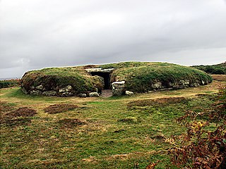
Porth Hellick Down is a Neolithic and Bronze Age archeological site located on the island of St Mary's, in the Isles of Scilly in Great Britain. The ancient burial monument encompasses a large cairn cemetery that includes at least six entrance graves, other unchambered cairns, and a prehistoric field system. The site is notable for having the largest assembly of surviving entrance graves.

Benllech is a large village on the Isle of Anglesey in Wales. It is in the community of Llanfair-Mathafarn-Eithaf, which has a population of 3,382, making it the fourth largest settlement on the island of Anglesey. The name of Benllech village had been removed by the time of the 2011 census with the community being listed under Llanfair-Mathafarn-Eithaf with the electoral ward being listed under Llanddyfnan. The built-up area has a population of 2,236.

Bodowyr Burial Chamber is a Neolithic burial chamber made of a few large stacked stones in a farmer's field on the north Wales island of Anglesey. It is located at Bodowyr Farm, 1.25 mi (2.0 km) east of Llangaffo, off the B4419 road.
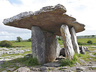
Poulnabrone dolmen is an unusually large dolmen or portal tomb located in the Burren, County Clare, Ireland. Situated on one of the most desolate and highest points of the region, it comprises three standing portal stones supporting a heavy horizontal capstone, and dates to the Neolithic period, probably between 4200 BC and 2900 BC. It is the best known and most widely photographed of the approximately 172 dolmens in Ireland.

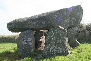
Pentre Ifan is the name of an ancient manor in the community and parish of Nevern, Pembrokeshire, Wales. It is 11 miles (18 km) from Cardigan, Ceredigion, and 3 miles (4.8 km) east of Newport, Pembrokeshire. Pentre Ifan contains and gives its name to the largest and best preserved neolithic dolmen in Wales.

Ambleston is a village, parish, and community in Pembrokeshire, Wales, lying seven miles (11 km) north-north-east of Haverfordwest. The parish includes the hamlets of Wallis and Woodstock.

Tinkinswood or its full name Tinkinswood Burial Chamber, also known as Castell Carreg, Llech-y-Filiast and Maes-y-Filiast, is a megalithic burial chamber, built around 6,000 years ago, during the Neolithic period, in the Vale of Glamorgan, near Cardiff, Wales.

Lligwy Burial Chamber is a Neolithic burial chamber in Lligwy, near the east coast of Anglesey, Wales, United Kingdom. It consists of a circle of upright stones, made into a low chamber by a very large roof slab estimated at 25 tonnes. Excavation in 1909 found the remains of some 15 to 30 people, and pottery suggesting a late Neolithic date. Close to the village of Moelfre, the site is within a few metres of the road, where there is room to leave a single car for short periods.

The St Lythans burial chamber is a single stone megalithic dolmen, built around 4,000 BC as part of a chambered long barrow, during the mid Neolithic period, in what is now known as the Vale of Glamorgan, Wales.

Parc Cwm long cairn, also known as Parc le Breos burial chamber, is a partly restored Neolithic chambered tomb, identified in 1937 as a Severn-Cotswold type of chambered long barrow. The cromlech, a megalithic burial chamber, was built around 5850 years before present (BP), during the early Neolithic. It is about seven 1⁄2 miles (12 km) west south–west of Swansea, Wales, in what is now known as Coed y Parc Cwm at Parc le Breos, on the Gower Peninsula.

Blackhammer Chambered Cairn is a Neolithic chambered cairn located on the island of Rousay, in Orkney, Scotland. The tomb, constructed around 3000 BC, is a Orkney–Cromarty chambered cairn, characterized by stalled burial compartments. Historic Environment Scotland established the site as a scheduled monument in 1994.
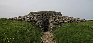
Quoyness chambered cairn is a Neolithic burial monument located on the island of Sanday in Orkney, Scotland. Similar to Maeshowe in design, the tomb was probably built around 3000 BC. The skeletal remains of several people were uncovered in the tomb during excavation in 1867. The monument was partially restored and reconstructed after a second excavation during the early 1950s, to display the different original stages of construction of the tomb. The property is now in the care of Historic Environment Scotland as a scheduled monument.
Tŷ Newydd Burial Chamber is a Neolithic dolmen located northeast of the village of Llanfaelog on the Isle of Anglesey in Wales. It is located near Tŷ Newydd farm, and is in the care of Cadw.
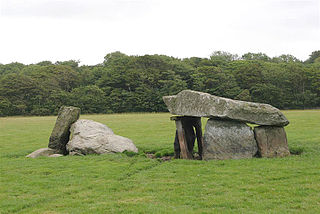
Presaddfed Burial Chamber is a listed monument in Anglesey, north Wales, comprising two Neolithic chamber tombs. It is a scheduled ancient monument and is located a short distance northwest of Bodedern. It is maintained by Cadw.

Din Dryfol is a Neolithic burial chamber on Anglesey, in Wales. It is a scheduled monument and is maintained by Cadw. The monument is near Bethel. Three phases of use have been identified, all dating from the Neolithic period.
Llanfair-Mathafarn-Eithaf is a parish and community in Anglesey, Wales including the small seaside town of Benllech. The community population taken at the 2011 census was 3,382.

Trefignath is a Neolithic burial chamber near Trearddur, south of Holyhead on Holy Island, off Anglesey in Wales. In its most complete form it included a large cairn covering three stone tombs, set on a small knoll. It was excavated between 1977 and 1979, revealing several phases of occupation with three separate burial chambers built in succession. It is a scheduled ancient monument, maintained by Cadw.

Perthi-Duon Burial Chamber is a Neolithic dolmen located to the west of Brynsiencyn, Anglesey, Wales.
