
Macon County is a county located in the U.S. state of North Carolina. As of the 2020 census, the population was 37,014. Its county seat is Franklin.
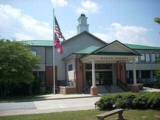
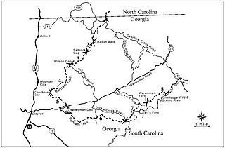
Rabun County is the north-easternmost county in the U.S. state of Georgia. As of the 2020 census, the population was 16,883, up from 16,276 in 2010. The county seat is Clayton. With an average annual rainfall of over 70 inches (1,800 mm), Rabun County has the title of the rainiest county in Georgia and is one of the rainiest counties east of the Cascades. The year 2018 was the wettest on record in the county's history. The National Weather Service cooperative observation station in northwest Rabun's Germany Valley measured 116.48 inches of rain during the year. During 2020, the Germany Valley NWS station reported a yearly precipitation total of 100.19 inches.

Tallulah Falls is a town in Habersham and Rabun counties in the U.S. state of Georgia near the Tallulah River. The population was 199 at the 2020 census.

Franklin is a town in and the county seat of Macon County, North Carolina, United States. It is situated within the Nantahala National Forest. The population was reported to be 4,175 in the 2020 census, an increase from the total of 3,845 tabulated in 2010.

The Tallulah River is a 47.7-mile-long (76.8 km) river in Georgia and North Carolina. It begins in Clay County, North Carolina, near Standing Indian Mountain in the Southern Nantahala Wilderness and flows south into Georgia, crossing the state line into Towns County. The river travels through Rabun County and ends in Habersham County. It cuts through the Tallulah Dome rock formation to form the Tallulah Gorge and its several waterfalls. The Tallulah River intersects with the Chattooga River to form the Tugaloo River at Lake Tugalo in Habersham County. It joins South Carolina's Seneca River at Lake Hartwell to form the Savannah River, which flows southeastward into the Atlantic Ocean.

The Laurel Falls Trail is an American hiking trail, in the Great Smoky Mountains National Park of Sevier County, Tennessee. The trail ascends Cove Mountain, leading past Laurel Falls, one of the most popular waterfalls in the national park, en route to the summit of Cove Mountain and the Cove Mountain fire tower.
The Bartram Trail follows the approximate route of 18th-century naturalist William Bartram’s southern journey from March 1773 to January 1777. Bartram explored much of the territory which is now the states of North and South Carolina, Georgia, Florida, Alabama, Mississippi, Louisiana and Tennessee.

Moccasin Creek State Park is a 32-acre (13 ha) state park located on the western shore of Lake Burton in Rabun County in the northeast corner of Georgia. The park features campgrounds; a fishing pier for the physically disabled, the elderly, and children; and walking trails. Even though the surrounding area is mountainous, the camping area is relatively flat.
The Coleman River Scenic Area is located in Rabun County, Georgia in the Chattooga River District of the Chattahoochee National Forest. It is located at the point of confluence of Coleman River with the Tallulah River. The scenic area consists of 330 acres (1.3 km2) encompassing lower Coleman River and was dedicated in 1960 to "Ranger Nick" Nicholson following his 40 years of public service. At the point of confluence of the two rivers, the elevation is approximately 2,200 feet (670 m).

The Tray Mountain Wilderness was designated in 1986 and currently consists of 9,702 acres (39.26 km2). The Wilderness is located within the borders of the Chattahoochee National Forest in Habersham, Rabun, Towns and White counties, Georgia and is managed in the Chattooga Ranger District. The Wilderness is managed by the United States Forest Service and is part of the National Wilderness Preservation System.

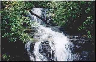
Minnehaha Falls is a series of cascades located on Falls Creek in Rabun County, Georgia. The waterfalls descend about 100 feet over a stepped rock formation. The falls are near Lake Rabun, within the boundaries of the Chattooga River Ranger District of the Chattahoochee National Forest.

Dukes Creek is the creek in White County, Georgia, on which gold was found in 1828. The discovery of gold in White County and neighboring Lumpkin County led to the Georgia Gold Rush. The creek is approximately 8.76 miles (14.10 km) long.

Raven Cliff Falls are located in White County, Georgia on a creek that joins Dodd Creek. The waterfall consists of three drops, a 60-foot (18 m) drop, followed by a 20-foot (6.1 m) drop into a deep pool, followed by a cascade of 20 feet (6.1 m) to Dodd Creek. The waterfall is an unusual double cascade flowing down through a fissure in a massive granite outcrop. There are also three other major waterfalls located on Dodd Creek, with the largest having a 70-foot (21 m) drop.
Becky Branch Falls is a twenty foot waterfall located in Rabun County, Georgia. The waterfall is located on the Bartram Trail in a valley called Warwoman Dell, east of Clayton, Georgia. In addition to accessing the falls via the Bartram Trail at the point where the trail crosses Warwoman Road, there is a short 0.6 mile loop trail called Becky Branch Falls Trail. This alternative trail connects is also accessed at the point where the Bartram Trail crosses Warwoman Road. The Bartram Trail also continues to nearby Martin Creek Falls. Becky Branch Falls is located within the boundaries of the Chattooga River Ranger District of the Chattahoochee National Forest.
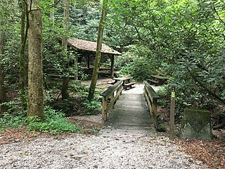
Warwoman Dell is a wooded valley or dell located east of Clayton, Georgia, United States, in Rabun County.

Coopey Falls is a waterfall on Coopey Creek in the Columbia River Gorge, on the Historic Columbia River Highway in Multnomah County, Oregon. The falls is a horsetail waterfall with a drop of 150 feet (46 m).
Panther Creek Falls Trail is an interior hiking trail in Georgia's Cohutta Mountains, in Fannin County, northwest of Ellijay, at the southern end of the Smoky Mountains. The trail falls within the 35,000-acre Cohutta Wilderness, part of the Wilderness's 87 mile (140 km) trail system. As an interior trail, Panther Creek Falls cannot be accessed by road, but only via other hiking trails. Eastern access is via the East Cowpen Trail, and its western access via the Conasauga River Trail. The trail starts at the confluence of Panther Creek and the Conasauga River.

Eagle Creek is a tributary of the Columbia River in Multnomah and Hood River counties in the U.S. state of Oregon. It cuts through a narrow canyon in its 3,200 feet (980 m) descent to the Columbia River Gorge and is known for its concentration of 13 waterfalls in about 5 miles (8.0 km) distance. Eight major falls are on Eagle Creek and the East Fork Eagle Creek itself, while five are on its tributaries.

Angel Falls is the second of two waterfalls on the Angel Falls Trail in Rabun County, Georgia. The first waterfall on the trail is Panther Falls.

