Parakao

Last updated

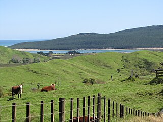
Parakao is a village and rural community in the Whangarei District and Northland Region of New Zealand's North Island. It is located on State Highway 15, southeast of Pakotai and northwest of Titoki. [1]

Whangarei District Territorial authority in Northland, New Zealand

Whangarei District is a territorial authority district in the Northland Region of New Zealand that is governed by the Whangarei District Council. The district is made up in area largely by rural land, and includes a fifth of the Northland Region. It extends southwards to the southern end of Bream Bay, northwards to Whangaruru and almost to the Bay of Islands, and westwards up the Mangakahia River valley past Pakotai and almost to Waipoua Forest. It includes the Hen and Chicken Islands and the Poor Knights Islands.

Northland Region region at the northern end of New Zealands North Island

The Northland Region is the northernmost of New Zealand's 16 local government regions. New Zealanders often call it the Far North or, because of its mild climate, the Winterless North. The main population centre is the city of Whangarei, and the largest town is Kerikeri.

North Island The northern of the two main islands of New Zealand

The North Island, also officially named Te Ika-a-Māui, is one of the two main islands of New Zealand, separated from the larger but much less populous South Island by Cook Strait. The island's area is 113,729 square kilometres (43,911 sq mi), making it the world's 14th-largest island. It has a population of 3,749,200.

The local Parakao Marae and Te Aroha-Parakao meeting house is a tribal meeting place for the Ngāpuhi hapū of Ngāti Horahia, Ngāti Moe, Ngāti Te Rino, Ngāti Toki, Te Parawhau and Ngāti Hine. [2] [3]

Ngāpuhi Māori iwi (tribe) in Aotearoa New Zealand

Ngāpuhi is a Māori iwi located in the Northland region of New Zealand, and centred in the Hokianga, the Bay of Islands, and Whangarei.

In Māoridom and New Zealand, a hapū functions as "the basic political unit within Māori society".

Ngāti Hine is an iwi with a rohe in Northland, New Zealand. It is part of the wider Ngāpuhi iwi. Ngāti Hine is descended from a female ancestor, Hineamaru, a great granddaughter of Rāhiri who settled in the Waiomio Valley, near Kawakawa. The prominent leader in the early years of European contact was Te Ruki Kawiti (1770s–1854).

Related Research Articles

Opononi Place in Northland Region, New Zealand

Opononi and Omapere are dual settlements on the south shore of the Hokianga harbour in Northland Region, New Zealand. State Highway 12 runs through Opononi and Omapere.

Ngawha Springs Place in Northland Region, New Zealand

Ngawha Springs is a small settlement approximately five kilometres east of the town of Kaikohe, Northland in New Zealand.

Ahipara Place in Northland Region, New Zealand

Ahipara is a town and locality in Northland, New Zealand at the southern end of Ninety Mile Beach, with the Tauroa Peninsula to the west and Herekino Forest to the east. Ahipara Bay is to the north west. Kaitaia is 14 km to the north east, and Pukepoto is between the two.

Herekino Place in Northland Region, New Zealand

Herekino is a locality in Northland, New Zealand. It lies 26 km south west of Kaitaia. The Herekino Harbour, also called the Herekino River, is an estuary and inlet from the Tasman Sea to the west. The Herekino Forest, which contains a stand of large kauri, is to the north, and the Tauroa Peninsula lies to the north west.

Horeke human settlement in New Zealand

Horeke is a settlement in the upper reaches of the Hokianga Harbour in Northland, New Zealand. Kohukohu is just across the harbour. The Horeke basalts are located near the town, and can be viewed on an easy stroll through the Wairere Boulders, a commercial park.

Omanaia Place in Northland Region, New Zealand

Omanaia is a settlement in the Hokianga area of Northland, New Zealand.

Oromahoe Place in Northland Region, New Zealand

Oromahoe is a locality in Northland, New Zealand. It lies on state highway 10.

Peria, Northland Place in Northland Region, New Zealand

Peria or Pēria is a locality in Northland, New Zealand. It lies south of Taipa and east of Kaitaia. The area was once known as Oruru Valley.

Tautoro Place in Northland Region, New Zealand

Tautoro is a locality in Northland, New Zealand. It lies about 8 km south east of Kaikohe.

Karikari Peninsula human settlement

The Karikari Peninsula on the east coast of the far north of Northland is between Rangaunu Harbour to the west, and Doubtless Bay to the southeast. It is a right-angled land mass of two relatively distinct parts. The rocky northern part, which has an east–west orientation and is approximately 17 km long, was originally an island but is now connected to the mainland by a low sandy tombolo approximately 11 km long, which has a north–south orientation. The spiritually significant Puwheke sits high above the north-facing beaches.

Whirinaki, Northland Place in Northland Region, New Zealand

Whirinaki is a locality in the south Hokianga, in Northland, New Zealand. The name means "to lean against a support". Highway 12 runs through it. Opononi lies to the south west, and Rawene lies to the north east.

Panguru Place in Northland Region, New Zealand

Panguru is a community in the northern Hokianga harbour, in Northland, New Zealand. The Whakarapa Stream flows from the Panguru Range in the Warawara Forest to the west, through Panguru and into the Hokianga.

Takapuwahia, also known as Porirua Pa, is the oldest settlement of Porirua City in the lower North Island of New Zealand.

Hihi or Hihi Beach is a village and rural community in the Far North District and Northland Region of New Zealand's North Island.

Waimahana Bay is a bay and remote rural community in the Far North District and Northland Region of New Zealand's North Island.

Whakapara is a village and rural community north of Whangarei, in the Whangarei District and Northland Region of New Zealand's North Island.

Ngararatunua or Ngāraratunua is a semi-rural community on the outskirts of Whangarei, in the Northland Region of New Zealand's North Island.

Nukutawhiti is a village and rural community in the Whangarei District and Northland Region of New Zealand's North Island. It is located on State Highway 15, south of Tautoro and north of Pakotai.

Takahiwai is a rural community west of Marsden Bay, in the Whangarei District and Northland Region of New Zealand's North Island.

Otaua or Ōtaua is a rural community in the Far North District and Northland Region of New Zealand's North Island.

References

  1. Hariss, Gavin. "Parakao, Northland". topomap.co.nz. NZ Topo Map.
  2. "Te Kāhui Māngai directory". tkm.govt.nz. Te Puni Kōkiri.
  3. "Māori Maps". maorimaps.com. Te Potiki National Trust.

Coordinates: 35°42′50″S173°57′18″E / 35.713756°S 173.954891°E / -35.713756; 173.954891

Geographic coordinate system Coordinate system

A geographic coordinate system is a coordinate system that enables every location on Earth to be specified by a set of numbers, letters or symbols. The coordinates are often chosen such that one of the numbers represents a vertical position and two or three of the numbers represent a horizontal position; alternatively, a geographic position may be expressed in a combined three-dimensional Cartesian vector. A common choice of coordinates is latitude, longitude and elevation. To specify a location on a plane requires a map projection.