Titoki (Māori: Tītoki) is a locality in the Mangakahia Valley of the Northland Region of New Zealand's North Island.[1]Whangārei is 26km (16mi) to the east. The Wairua River passes to the east of Titoki, and the Mangakahia River to the west.[2][3] A hydroelectric plant has been operating at Wairua Falls since 1916.[4] It was upgraded to produce 5.4 Gwh per year in 2007.[5]
Mangakahia Area School is a coeducational composite school (years 1–15), with a decile rating of 3 and a roll of 157.[8] The school, previously called Titoki District High School, celebrated its centennial in 2007.[9]
Titoki and the Mangakahia River area were important locations for the late 19th/early 20th century kauri gum digging trade.[10]
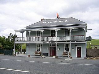
Tangiteroria is a small rural community in the North Island of New Zealand. It is located halfway between Whangārei and Dargaville on State Highway 14 on the banks of the Northern Wairoa river.
Towai is a locality in the Northland Region of the North Island of New Zealand. State Highway 1 passes just to the east. Kawakawa is 16 km northwest, and Whakapara is 17 km southeast. The North Auckland Line passes through Towai.
Ahipara is a town and locality in Northland, New Zealand at the southern end of Ninety Mile Beach, with the Tauroa Peninsula to the west and Herekino Forest to the east. Ahipara Bay is to the north west. Kaitaia is 14 km to the north east, and Pukepoto is between the two.
Awanui is an historical river port in the far north of New Zealand, on the banks of the Awanui River just before it flows into Rangaunu Bay. Awanui lies at the south end of the Aupouri Peninsula in the Far North District Council of the Northland Region, approximately 7 km north of Kaitaia. The river port has ceased operation and a recreational wharf is located at Unahi, on the shore of Rangaunu Bay, approximately 3 km north of the township. The traditional name of Awanui was Kaiwaka and Awanui proper refers to the "River at Kaiwaka". According to the 2013 New Zealand census, Awanui has a population of 339, a decrease of 9 people since the 2006 census.
Mangamuka is a district in Northland, New Zealand, at the junction of the Mangamuka and Opurehu Rivers. State Highway 1 runs through the area, and the settlement of Mangamuka Bridge lies at the point where the highway crosses the Mangamuku River. The river runs into the upper Hokianga Harbour. Just to the north west, the highway runs through Mangamuka Gorge in the Maungataniwha Range. Umawera lies to the south east.
Whangape Harbour is a harbour on the west coast of Northland, New Zealand. There is a settlement called Whangape on the northern side of the harbour. Another, called Pawarenga, is located on the southern side. Kaitaia is 42 km north east.
Waikare is a locality in Northland, New Zealand. The Waikare River flows from the Russell Forest past Waikare and into the Waikare Inlet, which leads into the Bay of Islands.
Aranga is a locality in Northland, New Zealand. State Highway 12 passes through it. Ōmāpere is 47 km northwest, and Dargaville is 42 km southeast. The Waipoua Forest is to the north. Maunganui Bluff and the Tasman Sea are to the west, with the small settlement of Aranga Beach lying at the northern end of Ripiro Beach.
Arapohue is a locality in Northland, New Zealand, approximately 16 km south east of Dargaville
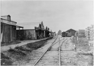
Kaihu is a locality and settlement in Northland, New Zealand. The Kaihu River runs through the Kaihu Valley into the Wairoa River near Dargaville, approximately 32 km south east. State Highway 12 runs along the valley and passes through Kaihu settlement. Aranga is about 10 km north west. The Kaihu Forest is to the east and the Marlborough Forest is to the north.
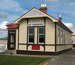
Matakohe is a settlement in Northland, New Zealand. The Matakohe River is a short river which runs from the north into the Arapaoa River, which is part of the Kaipara Harbour. State Highway 12 passes through Matakohe. Ruawai is 16 km to the west, and Paparoa is 6 km north east. The Hukatere Peninsula extends south into the Kaipara Harbour.
Tinopai is a settlement on the Komiti Bay, part of the Hukatere Peninsula in the northern Kaipara Harbour in Northland, New Zealand. The Otamatea River flows from the north east past Tinopai and into the harbour. Matakohe is 23 km (14 mi) to the north.
Karetu is a community in the Northland Region of the North Island of New Zealand. Kawakawa is to the west, and Waikare is northeast. The Karetu River flows from the Russell Forest in the southeast through Karetu, and joins the Kawakawa River shortly before it flows into the Bay of Islands.
Glenbervie is a settlement in Northland, New Zealand. The city of Whangārei lies to the southwest, and the localities of Kiripaka and Ngunguru to the northeast. The Glenbervie Forest is north of the settlement.
Otaika is a suburb of Whangārei 7 km south of the city in Northland, New Zealand. The Otaika Stream runs from the north west, through the area, and into the Whangārei Harbour. State Highway 1 runs through the locality. The hill Tikorangi lies to the South. Tikorangi is a source of limestone for Portland Cement.
Pakotai is a locality in the Mangakahia River Valley of Northland, New Zealand. Kaikohe is about 37 km to the north, and Maungatapere is about 34 km to the south east.
Pipiwai is a locality in the Te Horo valley in Northland, New Zealand. Whangārei is about 35 km to the southeast. Titoki is about 16 km to the south.
Whananaki is a locality on the east coast of Northland, New Zealand. Whangārei is to the southwest. Te Wairahi Stream flows from the northwest into Whananaki Inlet, a wide tidal estuary which separates Whananaki from Whananaki South. Sandy Bay lies to the southeast. A long wooden footbridge connects Whananaki North and Whananaki South, with an alternative connection being a 6-kilometre-long (3.7 mi) road that crosses the river above the estuary. Hikurangi is about 22 km southwest of Whananaki South.
Parakao is a village and rural community in the Whangarei District and Northland Region of New Zealand's North Island. It is located on State Highway 15, southeast of Pakotai and northwest of Titoki.
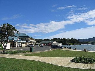
Mangōnui is a settlement on the west side of Mangōnui Harbour in Northland, New Zealand. State Highway 10 runs through it. It is the easternmost of the Taipa-Mangonui string of settlements, separated from Coopers Beach to the northwest by Mill Bay Road.
This page is based on this Wikipedia article Text is available under the CC BY-SA 4.0 license; additional terms may apply. Images, videos and audio are available under their respective licenses.