
Monaro Highway is a 285-kilometre-long (177 mi) highway in Victoria, New South Wales, and the Australian Capital Territory, in Australia, linking Cann River in Victoria to Canberra in the Australian Capital Territory (ACT) via the Monaro region. From its southern terminus, it follows the nearby Cann River upstream towards the New South Wales border through heavily forested terrain. Within New South Wales (NSW), it makes its way through further forest before reaching the pastures typical of the Monaro. There are multiple towns and villages along the highway, including Bombala, Nimmitabel, and Cooma. The terrain within the Monaro is largely hilly, and there are numerous crossings. The road also parallels the former Bombala railway line in several locations. Within the ACT, the road becomes a high volume roadway and serves the southern suburbs of Canberra. The highway has more recently had a grade-separated dual carriageway extension constructed within Canberra, as part of the Eastern Parkway construction project. It is designated part of route M23, and route A23 within Canberra, and route B23 within Victoria and New South Wales, with a concurrency where it also carries route B72 between the two sections of Snowy Mountains Highway.

Black Mountain, also known as Galambary to the Ngunnawal people, is a small mountain with an elevation of 812 metres (2,664 ft) AHD that is situated to the west of the Canberra central business district on the northern shore of Lake Burley Griffin, in the Australian Capital Territory of Australia. Black Mountain is protected from development by the Canberra Nature Park and is predominantly covered in native bushland and is a haven to native wildlife.

The Canberra Nature Park is a series of thirty three separate protected areas in and around Canberra, Australian Capital Territory, ranging from bushland hills to lowland native grassland. Many of the areas have previously been cleared for grazing, but many are now being returned to native bushland through revegetation and rehabilitation programs.

The Division of Canberra is an Australian electoral division in the Australian Capital Territory. It is named for the city of Canberra, Australia's national capital, and includes all of central Canberra, Kowen, Majura, as well as part of Weston Creek, Woden Valley, Molonglo Valley, Belconnen, and Jerrabomberra. It is currently held by Alicia Payne of the Labor Party.

Mount Majura is a small mountain with an elevation of 890 metres (2,920 ft) AHD that is located in the northern suburbs of Canberra in the Australian Capital Territory, Australia. Mount Majura lies close to the more prominent Mount Ainslie and is the highest point within the urban boundaries of Canberra. Mount Majura is contained within part of the Canberra Nature Park.

Ainslie is a suburb of Canberra, Australia in the North Canberra district.
McKellar is a residential suburb in the Belconnen district of Canberra, located within the Australian Capital Territory, Australia. The suburb is named after Colin McKellar who was Minister for Repatriation from 1964 to 1970. The suburb name was gazetted on 15 January 1974. The streets of McKellar are named for journalists with the main street of the suburb called Dumas Street. McKellar is bounded by Ginninderra Drive, William Webb Drive, Owen Dixon Drive, and Gundaroo Drive.
The Seat of Government Acceptance Act 1909 is an Australian Commonwealth Government act, that in conjunction with the Seat of Government Surrender Act 1909 transferred land from the state of New South Wales to the Commonwealth for the creation of the Federal Capital Territory.

The geology of the Australian Capital Territory includes rocks dating from the Ordovician around 480 million years ago, whilst most rocks are from the Silurian. During the Ordovician period the region—along with most of eastern Australia—was part of the ocean floor. The area contains the Pittman Formation consisting largely of Quartz-rich sandstone, siltstone and shale; the Adaminaby Beds and the Acton Shale.

Canberra railway station is located on the NSW TrainLink Regional Southern Line in the Australian Capital Territory, Australia. It is located in the Canberra suburb of Kingston.

Murray County was one of the original Nineteen Counties in New South Wales and is now one of the 141 Lands administrative divisions of New South Wales. It included the area which is now part of Canberra and as far north as Lake George and Yass. It was originally bounded on the west by the Murrumbidgee River, on the east by the Shoalhaven River and on the north by the Yass River. A large area of the county was transferred to the Commonwealth government in 1909 in the Seat of Government Acceptance Act to make part of the Australian Capital Territory, along with land in Cowley County. Since then, the ACT border is now part of the western boundary. Part of the ACT border is determined by property boundaries in the Parish of Keewong, in the County of Murray; specifically the southern end of portions 177, 218, 211, 36, and 38. This is mentioned in the Seat of Government Acceptance Act of 1909.
Yarrolumla Parish is a former parish of Murray County, New South Wales, a cadastral unit for use on land titles. It was formed in the nineteenth century, and existed until 1 January 1911, when the Seat of Government (Administration) Act 1910 came into force, after the land was transferred to the Commonwealth government in 1909 to be used to form the Australian Capital Territory.
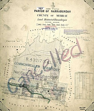
Narrabundah Parish is a former parish of Murray County, New South Wales, a cadastral unit for use on land titles. It was formed in the nineteenth century, and existed until 1 January 1911, when the Seat of Government (Administration) Act 1910 came into force, after the land was transferred to the Commonwealth government in 1909 to be used to form the Australian Capital Territory.

Tuggeranong Parish is a parish of Murray County, New South Wales, a cadastral unit for use on land titles. It is now about a third of the size it was in the nineteenth century, after most of the land in the parish was transferred to the Australian Capital Territory in 1911. It currently includes a small section of land in New South Wales between the ACT border and Jerrabomberra Creek, but once included most of what is now the Canberra town centre of Tuggeranong.
Pialligo Parish is a parish of Murray County, New South Wales, a cadastral unit for use on land titles. It is now a very tiny piece of land to the north-east of the Australian Capital Territory after most of the land in the parish was transferred to the ACT in 1911. It once included the area to the east of Mount Ainslie and the north of the Molonglo River, including Mount Majura and what is now Canberra Airport, and the suburb of Pialligo.
Gigerline Parish was a former parish of Murray County, New South Wales, a cadastral unit for use on land titles. It was formed in the nineteenth century and existed until 1 January 1911, when the Seat of Government (Administration) Act 1910 came into force, after the land was transferred to the Commonwealth government in 1909 to be used to form the Australian Capital Territory.

Canberra Central is a district in the Australian Capital Territory in Australia. Consisting of both the subdivisions of North Canberra and South Canberra. The district is subdivided into divisions (suburbs), sections and blocks. The district of Canberra Central lies entirely within the bounds of the city of Canberra, the capital city of Australia.

Sullivans Creek, a partly perennial stream of the Murrumbidgee catchment within the Murray–Darling basin, is located in Canberra, Australian Capital Territory, Australia.
Majura is a district in the Australian Capital Territory in Australia. With a population of 161 at the 2021 census, excluding the suburb of Pialligo, which lies to the south of Canberra Airport. Apart from Pialligo, Majura District includes Canberra Airport, three business parks and some farming but little residential development. The main shopping centre is the Majura Park Shopping Centre.
The Canberra-Yass railway is a proposed 64-kilometre (40 mi) link between the centre of Canberra and the Sydney-Melbourne rail line at Yass Junction, via Yass town.
