
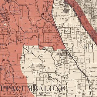
Merigan, New South Wales is a civil parish of Murray County, New South Wales. [1] [2]
The parish is on the Mulwaree River a few miles south of Tarago. It lies on the Bombala railway line and includes most of the locality of Mount Fairy.
Merigan, New South Wales is a civil parish of Murray County, New South Wales. [1] [2]
The parish is on the Mulwaree River a few miles south of Tarago. It lies on the Bombala railway line and includes most of the locality of Mount Fairy.

Murray County was one of the original Nineteen Counties in New South Wales and is now one of the 141 Lands administrative divisions of New South Wales. It included the area which is now part of Canberra and as far north as Lake George and Yass. It was originally bounded on the west by the Murrumbidgee River, on the east by the Shoalhaven River and on the north by the Yass River. A large area of the county was transferred to the Commonwealth government in 1909 in the Seat of Government Acceptance Act to make part of the Australian Capital Territory, along with land in Cowley County. Since then, the ACT border is now part of the western boundary. Part of the ACT border is determined by property boundaries in the Parish of Keewong, in the County of Murray; specifically the southern end of portions 177, 218, 211, 36, and 38. This is mentioned in the Seat of Government Acceptance Act of 1909.

Tuggeranong Parish is a parish of Murray County, New South Wales, a cadastral unit for use on land titles. It is now about a third of the size it was in the nineteenth century, after most of the land in the parish was transferred to the Australian Capital Territory in 1911. It currently includes a small section of land in New South Wales between the ACT border and Jerrabomberra Creek, but once included most of what is now the Canberra town centre of Tuggeranong.
Pialligo Parish is a parish of Murray County, New South Wales, a cadastral unit for use on land titles. It is now a very tiny piece of land to the north-east of the Australian Capital Territory after most of the land in the parish was transferred to the ACT in 1911. It once included the area to the east of Mount Ainslie and the north of the Molonglo River, including Mount Majura and what is now Canberra Airport, and the suburb of Pialligo.

Queanbeyan Parish is a parish of Murray County, New South Wales, a cadastral unit for use on land titles. It covers the city of Queanbeyan. It was originally bounded by the Molonglo River to the north, but is now bounded by the NSW-ACT border in the north and west. Parts of the western area of the parish were transferred to the Australian Capital Territory in 1909, including what are now the Canberra suburbs of Fyshwick, Narrabundah, Kingston, Oaks Estate, Harman and part of Hume.

Amungula Parish is a parish of Murray County, New South Wales, a cadastral unit for use on land titles. It is located in two non-contiguous sections, divided by the Australian Capital Territory, as most of the parish was transferred to the ACT in 1909 and now makes up much of the Kowen district. The northern section, the larger of the two, is located just to the south of Wamboin around 35°15′50″S149°17′29″E; the southern, a section of land between the Goulburn-Queanbeyan railway and the Molonglo River around 35°20′48″S149°19′49″E. Before 1909, the Molonglo River was the southern boundary of the parish. The Kings Highway passes through a small part of the southern remaining portion. It was formerly located in Yarrowlumla Shire, but is now located in Queanbeyan-Palerang Regional Council.

Carwoola Parish is a parish of Murray County, a cadastral unit for use on land titles. It is located to the south of the Australian Capital Territory and to the south-east of Queanbeyan. The original northern and eastern boundary was the Molonglo River; this is still the boundary for most of the parish, except in the north, where the relatively small area north of the Queanbeyan-Goulburn railway line was transferred to the ACT in 1909. The south-western boundary is the Queanbeyan River. Captain's Flat Road is the major road running through the parish. The area also roughly aligns with the locality of Carwoola.
Keewong Parish is a parish of Murray County, New South Wales, a cadastral unit for use on land titles. A small part of the north-western end of the parish around 35°34′40″S149°07′28″E between the Murrumbidgee River and the Queanbeyan-Cooma railway line was transferred to the Australian Capital Territory in 1909. The southern ends of portions 177, 218, 211, 36, and 38 in the Parish of Keewong form part of the border of the ACT with New South Wales, which is mentioned in the Seat of Government Acceptance Act of 1909.
Wallaroo Parish is one of the 54 parishes of Murray County, New South Wales, a cadastral unit for use on land titles. It is bounded by the Murrumbidgee River in the west, Ginninderra Creek in the south and Gooromon Ponds in the east. The Australian Capital Territory has also formed a small part of the boundary since 1909, after a small part of land in the parish at 35°11′54″S149°00′00″E was transferred to the Commonwealth. This area is just to the west of Dunlop. The Wallaroo road is the main road in the area, which comes off the Barton Highway. The parish is similar to the locality of Wallaroo.
The Parish of Wamboin is a parish of the County of Murray, a cadastral unit for use on land titles. It is located just to the north-east of the Australian Capital Territory and includes part of the town of Bungendore on the eastern edge and the rural community of Wamboin near the south-western edge.

The Parish of Lake George is an Australian parish of the County of Murray which covers Lake George and part of the surrounding area. It is at the northern boundary of the county, with Argyle to the north-east. The Federal Highway runs through the parish where it runs to the west of the lake. Some parish maps of the area just record it as a lake and not as a parish, however it does have separate parish maps.
Araluen Creek, a partly perennial stream of the Moruya River catchment, is located in the Southern Tablelands and South Coast regions of New South Wales, Australia.
Jerrabattgulla Creek, a perennial stream of the Shoalhaven River catchment, is located in the Southern Tablelands region of New South Wales, Australia.
Bettowynd Creek, a partly perennial stream of the Moruya River catchment, is located in the Southern Tablelands and South Coast regions of New South Wales, Australia.
Ellenden Parish, is a civil parish of Murray County, New South Wales.
Currandooly Parish is a civil parish of Murray County, New South Wales.
Ballallaba Parish is a civil parish of Murray County, New South Wales.
Larbert Parish is a civil parish of Murray County, New South Wales.
Monkellan Parish is a civil parish of Murray County, New South Wales.
Molonglo Parish, New South Wales is a civil parish of Murray County.
Jinglemoney Parish is a civil parish of Murray County, New South Wales. It is located around Bombay on Bombay Creek, a tributary of the Shoalhaven River in the Queanbeyan–Palerang Regional Council.
35°07′57″S149°37′02″E / 35.13250°S 149.61722°E
| | This Southern Tablelands geography article is a stub. You can help Wikipedia by expanding it. |