
The Australian Capital Territory (ACT), known as the Federal Capital Territory (FCT) until 1938, is a federal territory of Australia. Canberra, the capital city of Australia, is located in this territory. It is located in southeastern Australian mainland as an enclave completely within the state of New South Wales. Founded after Federation as the seat of government for the new nation, the territory hosts the headquarters of all important institutions of the Australian Government.

Monaro Highway is a 285-kilometre-long (177 mi) highway in Victoria, New South Wales, and the Australian Capital Territory, in Australia, linking Cann River in Victoria to Canberra in the Australian Capital Territory (ACT) via the Monaro region. From its southern terminus, it follows the nearby Cann River upstream towards the New South Wales border through heavily forested terrain. Within New South Wales (NSW), it makes its way through further forest before reaching the pastures typical of the Monaro. There are multiple towns and villages along the highway, including Bombala, Nimmitabel, and Cooma. The terrain within the Monaro is largely hilly, and there are numerous crossings. The road also parallels the former Bombala railway line in several locations. Within the ACT, the road becomes a high volume roadway and serves the southern suburbs of Canberra. The highway has more recently had a grade-separated dual carriageway extension constructed within Canberra, as part of the Eastern Parkway construction project. It is designated part of route M23, and route A23 within Canberra, and route B23 within Victoria and New South Wales, with a concurrency where it also carries route B72 between the two sections of Snowy Mountains Highway.

The Canberra Nature Park is a series of thirty three separate protected areas in and around Canberra, Australian Capital Territory, ranging from bushland hills to lowland native grassland. Many of the areas have previously been cleared for grazing, but many are now being returned to native bushland through revegetation and rehabilitation programs.

Narrabundah is a leafy, medium density suburb of Canberra, Australian Capital Territory, located in the inner south of the city.

Red Hill is a suburb of Canberra, Australian Capital Territory, Australia. The suburb is named after the northernmost hill of the ridge to the west of the suburb. The ridge is a reserve and managed as part of the Canberra Nature Park. The hill is an element of the central Canberra design axis.

Mount Majura is a small mountain with an elevation of 890 metres (2,920 ft) AHD that is located in the northern suburbs of Canberra in the Australian Capital Territory, Australia. Mount Majura lies close to the more prominent Mount Ainslie and is the highest point within the urban boundaries of Canberra. Mount Majura is contained within part of the Canberra Nature Park.

Hall is a town in the district of Hall, in the Australian Capital Territory in Australia. Is situated on the north side of the Australian Capital Territory. At the 2021 census, the village had a population of 298 people. It is surrounded by open country and has a rural appearance. Hall has retained a village character. The town features historic buildings that existed before the establishment of Canberra.
Oaks Estate is a suburb in the district of Jerrabomberra, Canberra, Australian Capital Territory in Australia. Is situated on the northern side of the Australian Capital Territory and New South Wales border abutting the town of Queanbeyan in south-eastern New South Wales, Australia. The estate covers an area of approximately 40 hectares and is bound by the Molonglo River to the north, the Queanbeyan River to the east, 'The Oaks' to the west, and the Queanbeyan-Cooma railway to the south. Oaks Estate is located 12 kilometres from the centre of Canberra. The village is also noteworthy as the nucleus of Queanbeyan's industrial development during the second half of the 19th century. Oaks Estate takes its name from 'The Oaks', which was part of Duntroon, Robert Campbell's farming estate. This makes Oaks Estate one of only a few place names in the ACT with significant connections to early colonial times.
The Seat of Government Acceptance Act 1909 is an Australian Commonwealth Government act, that in conjunction with the Seat of Government Surrender Act 1909 transferred land from the state of New South Wales to the Commonwealth for the creation of the Federal Capital Territory.

The geology of the Australian Capital Territory includes rocks dating from the Ordovician around 480 million years ago, whilst most rocks are from the Silurian. During the Ordovician period the region—along with most of eastern Australia—was part of the ocean floor. The area contains the Pittman Formation consisting largely of Quartz-rich sandstone, siltstone and shale; the Adaminaby Beds and the Acton Shale.

Lands administrative divisions of Australia are the cadastral divisions of Australia for the purposes of identification of land to ensure security of land ownership. Most states term these divisions as counties, parishes, hundreds, and other terms. The eastern states of Queensland, New South Wales, Victoria, and Tasmania were divided into counties and parishes in the 19th century, although the Tasmanian counties were renamed land districts in the 20th century. Parts of South Australia (south-east) and Western Australia (south-west) were similarly divided into counties, and there were also five counties in a small part of the Northern Territory. However South Australia has subdivisions of hundreds instead of parishes, along with the Northern Territory, which was part of South Australia when the hundreds were proclaimed. There were also formerly hundreds in Tasmania. There have been at least 600 counties, 544 hundreds and at least 15,692 parishes in Australia, but there are none of these units for most of the sparsely inhabited central and western parts of the country.

Murray County was one of the original Nineteen Counties in New South Wales and is now one of the 141 Lands administrative divisions of New South Wales. It included the area which is now part of Canberra and as far north as Lake George and Yass. It was originally bounded on the west by the Murrumbidgee River, on the east by the Shoalhaven River and on the north by the Yass River. A large area of the county was transferred to the Commonwealth government in 1909 in the Seat of Government Acceptance Act to make part of the Australian Capital Territory, along with land in Cowley County. Since then, the ACT border is now part of the western boundary. Part of the ACT border is determined by property boundaries in the Parish of Keewong, in the County of Murray; specifically the southern end of portions 177, 218, 211, 36, and 38. This is mentioned in the Seat of Government Acceptance Act of 1909.

Canberra Parish is a former parish of Murray County, New South Wales, a cadastral unit for use on land titles. It was formed in the nineteenth century, and existed until 1 January 1911, when the Seat of Government (Administration) Act 1910 came into force, after the land was transferred to the Commonwealth government in 1909 to be used to form the Australian Capital Territory.
Yarrolumla Parish is a former parish of Murray County, New South Wales, a cadastral unit for use on land titles. It was formed in the nineteenth century, and existed until 1 January 1911, when the Seat of Government (Administration) Act 1910 came into force, after the land was transferred to the Commonwealth government in 1909 to be used to form the Australian Capital Territory.

Tuggeranong Parish is a parish of Murray County, New South Wales, a cadastral unit for use on land titles. It is now about a third of the size it was in the nineteenth century, after most of the land in the parish was transferred to the Australian Capital Territory in 1911. It currently includes a small section of land in New South Wales between the ACT border and Jerrabomberra Creek, but once included most of what is now the Canberra town centre of Tuggeranong.
Pialligo Parish is a parish of Murray County, New South Wales, a cadastral unit for use on land titles. It is now a very tiny piece of land to the north-east of the Australian Capital Territory after most of the land in the parish was transferred to the ACT in 1911. It once included the area to the east of Mount Ainslie and the north of the Molonglo River, including Mount Majura and what is now Canberra Airport, and the suburb of Pialligo.

Queanbeyan Parish is a parish of Murray County, New South Wales, a cadastral unit for use on land titles. It covers the city of Queanbeyan. It was originally bounded by the Molonglo River to the north, but is now bounded by the NSW-ACT border in the north and west. Parts of the western area of the parish were transferred to the Australian Capital Territory in 1909, including what are now the Canberra suburbs of Fyshwick, Narrabundah, Kingston, Oaks Estate, Harman and part of Hume.
Gigerline Parish was a former parish of Murray County, New South Wales, a cadastral unit for use on land titles. It was formed in the nineteenth century and existed until 1 January 1911, when the Seat of Government (Administration) Act 1910 came into force, after the land was transferred to the Commonwealth government in 1909 to be used to form the Australian Capital Territory.
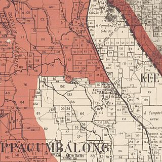
Keewong Parish is a parish of Murray County, New South Wales, a cadastral unit for use on land titles. A small part of the north-western end of the parish around 35°34′40″S149°07′28″E between the Murrumbidgee River and the Queanbeyan-Cooma railway line was transferred to the Australian Capital Territory in 1909. The southern ends of portions 177, 218, 211, 36, and 38 in the Parish of Keewong form part of the border of the ACT with New South Wales, which is mentioned in the Seat of Government Acceptance Act of 1909.
Majura is a district in the Australian Capital Territory in Australia. With a population of 161 at the 2021 census, excluding the suburb of Pialligo, which lies to the south of Canberra Airport. Apart from Pialligo, Majura District includes Canberra Airport, three business parks and some farming but little residential development. The main shopping centre is the Majura Park Shopping Centre.
