
The Inner West of Sydney is an area directly west of the Sydney central business district, New South Wales, Australia. The suburbs that make up the Inner West are predominantly located along the southern shore of Port Jackson, stretching south to the shores of the Cooks River. The western boundary of the Inner West is approximately the A3 arterial road, which divides the Inner West from the Greater Western Sydney region. The Inner West is much larger than the Inner West Council local government area. The Inner West roughly corresponds with the Parish of Petersham and Parish of Concord, two cadastral divisions used for land titles.
Southern Sydney is the southern metropolitan area of Greater Sydney, in the state of New South Wales, Australia.

Cumberland County is a county in the State of New South Wales, Australia. Most of the Sydney metropolitan area is located within the County of Cumberland.

The St George region of Sydney is part of the southern suburbs of Sydney, in the state of New South Wales, Australia. The area includes all the suburbs in the local government area of Georges River Council and the part of Bayside Council which was Rockdale City prior to 2016. This is everything within the boundaries of Salt Pan Creek to the west, The Georges River to the south, Botany Bay to the east and the M5 Motorway and Wolli Creek to the north. This area corresponds to the southern portion of the cadastral Parish of St George, from which the region derives its name and the area was later covered by the St George County Council, the electricity supplier for the councils in this region. This southern portion of the parish below The M5 and Wolli Creek is the more contemporary definition of The St George Region that is considered part of Southern Sydney.
Salt Pan Creek is an urban watercourse of the Georges River catchment, located in the Canterbury-Bankstown region of Sydney, in New South Wales, Australia.
Picnic Point, a suburb of local government area City of Canterbury-Bankstown, is 23 kilometres south-west of the Sydney central business district, in the state of New South Wales, Australia. It is a part of South-western Sydney region. Picnic Point is a residential suburb on the northern bank of the Georges River. Located within Picnic Point is Yeramba Lagoon which is the largest tract of National Park within the Canterbury – Bankstown Council, it is home to numerous species of native fauna and flora.

Padstow Heights, a suburb of local government area of the City of Canterbury-Bankstown, located 22 kilometres south-west of the Sydney central business district, in the state of New South Wales, Australia. It is a part of the South-western Sydney region. Padstow is a separate suburb to the north and One Tree Point is a locality within Padstow Heights.

Chester Hill, a suburb of Sydney, located 25 kilometres west of the Sydney central business district, in the state of New South Wales, Australia. Chester Hill is mostly in the City of Canterbury-Bankstown, with a minor part in the northeast in the Cumberland Council local government area. Part of Western Sydney, Chester Hill shares the postcode of 2162 with the neighbouring suburb of Sefton, to the east.
Earlwood is a suburb of Sydney, in the state of New South Wales, Australia. Earlwood is located 10 kilometres south-west of the Sydney central business district, and is part of the Canterbury-Bankstown area. It is in the local government area of the City of Canterbury-Bankstown.

Belfield is a suburb of Sydney, in the state of New South Wales, Australia. It is 13 kilometres southwest of the Sydney central business district, in the local government area of the City of Canterbury-Bankstown.

Hunters Hill Parish is one of the 57 parishes of Cumberland County, New South Wales, a cadastral unit for use on land titles. It includes the eponymous suburb of Hunters Hill and the Municipality of Hunter's Hill in the east, while the western part of the parish largely corresponds with the City of Ryde.

Petersham Parish is one of the 57 parishes of Cumberland County, New South Wales, a cadastral unit for use on land titles. It is located to the south of Iron Cove, Rozelle Bay and the Parramatta River, and to the north of Cooks River. It includes the suburbs of Balmain, Leichhardt, Petersham, Newtown, Marrickville, Tempe, Glebe and St Peters. It roughly corresponds to the eastern half of the Inner West region, with the neighbouring Parish of Concord making up the western half.

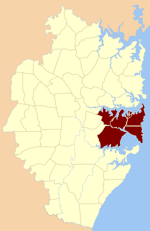
Concord Parish is one of the 57 parishes of Cumberland County, New South Wales, a cadastral unit for use on land titles. It is located to the south of the Parramatta River between Homebush Bay and Iron Cove; and to the north of Cooks River. It includes the suburbs of Homebush, most of Strathfield, Burwood, Croydon, Concord, Canada Bay, Abbotsford and Drummoyne. It covers the local government areas of City of Canada Bay and the Municipality of Burwood and most of the Municipality of Strathfield. It roughly corresponds to the western half of the Inner West region, with the neighbouring Parish of Petersham making up the eastern half.
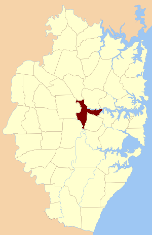
St John Parish is one of the 57 parishes of Cumberland County, New South Wales, a cadastral unit for use on land titles. It is named after St John's Cathedral in Parramatta, New South Wales which opened in 1803, on which the civil parish is roughly centred. The parish is shaped like a "T", with the northern part stretching from Toongabbie to the western shore of Homebush Bay. The southern end is at Prospect Creek near Yennora. Woodville Road and Parramatta Road form the boundaries to the south-east. The Old Prospect Road is part of the boundary in the west.

St Lawrence Parish is one of the 57 parishes of Cumberland County, New South Wales, Australia, a cadastral unit for use on land titles. It is one of the four small parishes in the Sydney city area. Unlike the other three parishes, St Lawrence was not named after a New Testament saint but after St Lawrence, the second Bishop of Canterbury, successor to St Augustine of Canterbury, presumably very familiar to Bishop Broughton from his time in Canterbury. The church in the parish was dedicated by the bishop as Christ Church. Later, as it became more "tractarian" and Anglo-Catholic, the name of the parish was added to that of the church. However, by then, St Lawrence was understood to refer to the only saint of that name in the Book of Common Prayer, St Lawrence, of Rome, and St Laurence of Rome has since been considered the patron saint of the church..
The Hundred of Sydney is a former lands administrative division for the city of Sydney and its inner suburbs. It was one of the thirteen hundreds in the County of Cumberland, which were published in the government gazette of May 27, 1835, and repealed on January 21, 1888.

Cup and Saucer Creek, an urban watercourse of the Cooks River catchment, is located in the Canterbury-Bankstown region of Sydney, in New South Wales, Australia.
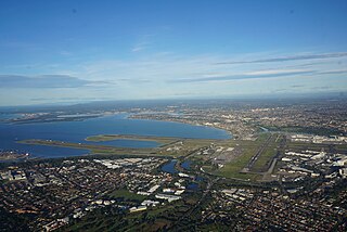
The metropolis of Greater Sydney in New South Wales, Australia, is informally subdivided into a number of geographic regions. The geographical definition of Greater Sydney spans across 33 local government areas and includes the Blue Mountains in the west, the Northern Beaches and the Hawkesbury in the north, the Royal National Park, the Wollondilly and Macarthur in the south, and Botany Bay in the east. These areas sometimes, but not always, roughly coincide with official boundaries of suburbs, local government authorities, or cadastral units, and some of the customary regions do not have well defined boundaries at all. Some commonly referred to regions overlap: for example, Canterbury-Bankstown is often referred to as a region, but it is also part of the South Western Sydney region. The regions themselves are not used as a formal jurisdiction, and generally do not have administrative or legislative bodies, although some regions are coterminous with a local government area, and in a number of regions that include multiple local government areas, Regional Organisations of Councils have been established that represent the councils in the region.
The assistant bishops of Sydney are the assistant bishops in the Anglican Diocese of Sydney, Australia. They each assist the Archbishop of Sydney by maintaining delegated episcopal oversight over a particular geographical area.

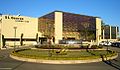
Canterbury-Bankstown Council, trading as the City of Canterbury Bankstown, is a local government area in the Canterbury-Bankstown region of Sydney, New South Wales, Australia. The council was formed on 12 May 2016 from a merger of the City of Canterbury and the City of Bankstown, after a review of local government areas by the NSW Government.

 The St George Illawarra Dragons leagues club, the name of the football team came indirectly from the original parish name.
 Parish of St George, New South Wales in 1840. [4]
