Parliament Gardens

Last updated
Parliament Gardens
Parliament gardens, Windhoek.jpg
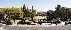
View of Parliament Gardens from the Tintenpalast steps
Parliament Gardens
TypeNatural Area
Location Namibia, Windhoek
Created2022 (2022)
Operated by College of the Arts. [1]
Monument of Captain Hendrik Samuel Witbooi at Parliament Gardens in Windhoek Captain Hendrik Samuel Witbooi Monument Parliament Gardens Windhoek.jpg
Monument of Captain Hendrik Samuel Witbooi at Parliament Gardens in Windhoek

The Parliament Gardens is a small park in downtown Windhoek, Namibia. It is located between the Tintenpalast (Namibia's Parliament building) and the Christuskirche. It was laid out in 1932 and was originally called the Tintenpalast gardens, adopting its present name after Namibian independence in 1990. [2]

Facing the Tintenpalast Reg palast.jpg
Facing the Tintenpalast

The Parliament Gardens contain Namibia's first post-independence monument: a bronze-cast statue of the Herero chief Hosea Kutako. [3] Two other Namibian nationalists are also honoured with bronze statues in the gardens: Hendrik Samuel Witbooi and Theophilus Hamutumbangela. [2] The three statues flank the steps towards the main entrance of the parliament building. [4]

The gardens used to be an olive plantation,[ citation needed ] and still include an olive grove. [3] They also contain a bowling green lined with bougainvilleas along with a thatched-roof clubhouse. [4] Twice a month the gardens host "Theatre in the Park", run by the College of the Arts. [5]

In 2016, the opening of the Namibian Parliament was held in the Parliament Gardens because of limited space in the Tintenpalast. Due to a change to the Constitution in 2014, the number of parliamentarians had increased significantly, and so joint sittings have to be held elsewhere. [6]

Rough Guides describes the Parliament Gardens as "delightful, shady... definitely merit a stroll". [4] The gardens are "particularly popular at lunchtimes and weekends, when students laze on the lawns pouring over their books or each other." [4] They are also a "popular place for a lunchtime picnic." [7]

Related Research Articles

The history of Namibia has passed through several distinct stages from being colonised in the late nineteenth century to Namibia's independence on 21 March 1990.

<span class="mw-page-title-main">Windhoek</span> Capital and largest city of Namibia

Windhoek is the capital and largest city of Namibia. It is located in central Namibia in the Khomas Highland plateau area, at around 1,700 m (5,600 ft) above sea level, almost exactly at the country's geographical centre. The population of Windhoek in 2020 was 431,000 which is growing continually due to a continued migration from other regions in Namibia.

<span class="mw-page-title-main">Popular Democratic Movement</span> Political party in Namibia

The Popular Democratic Movement (PDM), formerly the Democratic Turnhalle Alliance (DTA), is an amalgamation of political parties in Namibia, registered as one singular party for representation purposes. In coalition with the United Democratic Front, it formed the official opposition in Parliament until the parliamentary elections in 2009. The party currently holds 16 seats in the Namibian National Assembly and one seat in the Namibian National Council and is the official opposition. McHenry Venaani is president of the PDM.

<span class="mw-page-title-main">Okaukuejo</span> Place in Oshana Region, Namibia

Okaukuejo is the administrative center for the Etosha National Park in Namibia. It is located approximately 650 km from the capital Windhoek. An average annual rainfall of around 350 millimetres (14 in) is received, although in the 2010/2011 rainy season 676 millimetres (26.6 in) were measured.

<span class="mw-page-title-main">Parliament Building, Windhoek</span> Building in Namibia

The Parliament Building, Windhoek, also known as the Tintenpalast, is the seat of both houses of the Parliament of Namibia. It is located in the Namibian capital of Windhoek.

<span class="mw-page-title-main">Mukurob</span>

The Mukurob, also Vingerklip in Afrikaans or "Finger of God" near Asab in Namibia, was a sandstone rock formation in the Namib desert which collapsed on 7 December 1988.

<span class="mw-page-title-main">Tourism in Namibia</span> Economic sector in Namibia

Tourism in Namibia is a major industry, contributing N$7.2 billion to the country's gross domestic product. Annually, over one million travelers visit Namibia, with roughly one in three coming from South Africa, then Germany and finally the United Kingdom, Italy and France. The country is among the prime destinations in Africa and is known for ecotourism which features Namibia's extensive wildlife.

<span class="mw-page-title-main">Heroes' Acre (Namibia)</span> War memorial in Namibia

Heroes' Acre is an official war memorial of the Republic of Namibia. Built into the uninhabited hills 10 kilometres (6 mi) south of the city centre of Windhoek, Heroes' Acre opened on 26 August 2002. It was created to "foster a spirit of patriotism and nationalism, and to pass [this] to the future generations of Namibia".

<span class="mw-page-title-main">White Namibians</span> Ethnic group in Namibia

White Namibians are people of European descent settled in Namibia. The majority of White Namibians are Dutch-descended Afrikaners, with many of the White minority being German Namibians. Many are also Portuguese or English immigrants. Estimates published in 2016 suggest that the White Namibian population run between 75,000 and 150,000. This imprecision in data is because the Namibian government no longer collects data based on race.

<span class="mw-page-title-main">Nxai Pan</span>

Nxai Pan is a large salt pan topographic depression which is part of the larger Makgadikgadi Pans in northeastern Botswana. It lies on the old Pandamatenga Trail, which until the 1960s was used for overland cattle drives. The area is speckled with umbrella acacias and is said to resemble the Serengeti in Tanzania. The Nxai Pan was added to the National Park System to augment the Makgadikgadi Pans National Park, thus providing an enlarged contiguous area of natural protection.

<span class="mw-page-title-main">Ethnic groups in Botswana</span>

The population of Botswana is divided into the main ethnic groups of Tswana people (73%), Kalanga people (18%), and Basarwa (2%). The remaining 7% consist of other peoples, including some speaking the Kgalagadi language, and 1% of non-African people.

<span class="mw-page-title-main">Bagani, Namibia</span> Settlement in Kavango East, Namibia

Bagani is a settlement on the south-western banks of the Okavango River in the Kavango East Region of Namibia, 200 kilometres (120 mi) east of Rundu and near the Popa Falls on the Okavango River. Bagani has a population of around 2.000 inhabitants and is homestead of the local Mbukushu kings.

<span class="mw-page-title-main">Asab</span> Settlement in ǁKaras Region, Namibia

Asab is a settlement in the ǁKaras Region of southern Namibia. It is situated on the B1 national road about halfway between Mariental and Keetmanshoop. 23 km (14 mi) east of Asab is the Mukurob rock pinnacle, a tourist attraction that collapsed on 7 December 1988.

<span class="mw-page-title-main">Tippu Tip's House</span>

Tippu Tip's House is a historical building in Stone Town, Zanzibar, located in Suicide Alley in the Shangani ward near the Africa House Hotel and Serena Inn, about 15–25 minute walking time from the Old Fort and Forodhani Gardens. It is the house where the powerful merchant and slave trader Tippu Tip (1837–1905) lived. The building was a private residence until the Zanzibar Revolution and was later converted into a block of flats.

<span class="mw-page-title-main">Reiterdenkmal, Windhoek</span> 1912–2013 monument in the Namibian capital

The Equestrian Monument, more commonly known under its German original name Reiterdenkmal and the name Südwester Reiter, was a monument in Windhoek, the capital of Namibia. It was inaugurated on 27 January 1912, the birthday of German emperor Wilhelm II. The monument honoured the soldiers and civilians that died on the German side of the Herero and Namaqua War of 1904–1907, a situation that caused controversy about its role in a democratic Namibia that has shed its colonial occupation and gained independence.

<span class="mw-page-title-main">Statue of Nelson Mandela, Johannesburg</span> Statue in Sandton, Gauteng

The statue of Nelson Mandela is a large bronze sculpture of the former President of South Africa and anti-apartheid activist Nelson Mandela, located in Nelson Mandela Square in Sandton, Gauteng.

Reverend Theophilus Hingashikuka Hamutumbangela was a Namibian anti-apartheid activist, priest, and leading international promoter of Namibian independence, working alongside British anti-apartheid activist Reverend Michael Scott.

<span class="mw-page-title-main">Independence Memorial Museum (Namibia)</span> History museum in Windhoek, Namibia

The Independence Memorial Museum is a history museum in Windhoek, the capital of Namibia. It focuses on the anti-colonial resistance and the national liberation movement of Namibia.

The following is a timeline of the history of the city of Windhoek, Namibia.

References

  1. McIntyre, Chris (2011). Namibia. Bradt Travel Guides. p. 145. ISBN   9781841623351 . Retrieved 16 October 2016.
  2. 1 2 Olivier, Willie; Olivier, Sandra (2006). African Adventurer's Guide to Namibia. Struik. p. 110. ISBN   9781868728589 . Retrieved 16 October 2016.[ permanent dead link ]
  3. 1 2 "Tintenpalast". Lonely Planet . Retrieved 15 October 2016.
  4. 1 2 3 4 "Parliament Gardens". Rough Guides. Archived from the original on 18 October 2016. Retrieved 16 October 2016.
  5. McIntyre, Chris (2011). Namibia. Bradt Travel Guides. p. 145. ISBN   9781841623351 . Retrieved 16 October 2016.
  6. "Parliament opening moves to garden due to space constraints". New Era . 9 February 2016. Archived from the original on 10 February 2016. Retrieved 16 October 2016.
  7. "Namibia Tourist Attractions and Sightseeing". World Guides. Retrieved 15 October 2016.

22°34′01″S17°05′17″E / 22.567°S 17.088°E / -22.567; 17.088