Related Research Articles

Leonora is a town in the Goldfields-Esperance region of Western Australia, located 833 kilometres (518 mi) northeast of the state capital, Perth, and 237 kilometres (147 mi) north of the city of Kalgoorlie.

Southern Cross is a town in Western Australia, 371 kilometres east of state capital Perth on the Great Eastern Highway. It was founded in 1888 after gold prospectors Richard Greaves and Ted Paine during their October 1887 expedition successfully found gold, and gazetted in 1890. It is the major town and administrative centre of the Shire of Yilgarn. At the 2016 census, Southern Cross had a population of 680.

Coolgardie–Esperance Highway is a 370-kilometre (230 mi) Western Australian highway between Coolgardie and Esperance. It runs in a north–south direction linking the state's Eastern Goldfields to the coast.
Parkeston is a suburb of the city of Kalgoorlie, Western Australia, located 3 kilometres (1.9 mi) east of the city centre. At the 2016 census, it had a population of 60, down from 69 in 2006. It contains the Ninga Mia Aboriginal community.

The Trans-Australian Railway, opened in 1917, runs from Port Augusta in South Australia to Kalgoorlie in Western Australia, crossing the Nullarbor Plain in the process. As the only rail freight corridor between Western Australia and the eastern states, the line is economically and strategically important. The railway includes the world's longest section of completely straight track.

The City of Kalgoorlie–Boulder is a local government area in the Goldfields–Esperance region of Western Australia, about 550 kilometres (342 mi) east of the state capital, Perth. Its seat of government is the town of Kalgoorlie; all but 244 of the city's population live in either Kalgoorlie or Boulder.
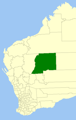
The Shire of Wiluna is a local government area in the Goldfields-Esperance region of Western Australia, about 950 kilometres (590 mi) northeast of the state capital, Perth. The Shire covers an area of 182,155 square kilometres (70,330 sq mi), and its seat of government is the town of Wiluna.
Kalgoorlie railway station is the easternmost attended station in Western Australia, located at the eastern terminus of the Eastern Goldfields Railway. It serves the city of Kalgoorlie. Beyond Kalgoorlie, the line continues east as the Trans-Australian Railway.

The network of railway lines in Western Australia associated with the timber and firewood industries is as old as the mainline railway system of the former Western Australian Government Railways system.
Broad Arrow is a ghost town in Western Australia, located 38 km north of Kalgoorlie and 633 km east of Perth. It is on the Kalgoorlie to Leonora Road.
The Esperance branch railway is a railway from Kalgoorlie to the port of Esperance in Western Australia.
Comet Vale is an abandoned town in Western Australia located in the Goldfield region of Western Australia located between Kalgoorlie and Laverton on the Goldfields Highway. It is within the Shire of Menzies.
John Marquis Hopkins was an Australian politician. He was a member of the Legislative Assembly of Western Australia, representing the electoral districts of Boulder and Beverley. He had previously been mayor of Boulder. In 1910 he was jailed for five years for uttering, but was released in October 1911.
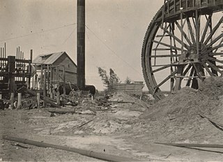
State Batteries in Western Australia were government owned and run ore-crushing facilities for the gold mining industry. Western Australia was the only Australian state to provide batteries to assist gold prospectors and small mines. They existed in almost all of the mineral fields of Western Australia.
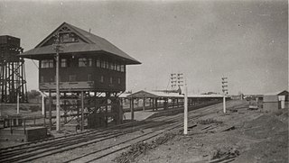
The Meekatharra to Wiluna railway was a 113-mile (182 km) branch line of the Western Australian Government Railways that extended the Mullewa – Meekatharra railway from Meekatharra to Wiluna and operated between 1932 and 1957. Wiluna was the furthest rail terminus from Perth on the Western Australian Government Railways system. Paroo was the highest station, at 1,916 feet (584 m) above sea level; the highest point on the Western Australian railway network, west of Paroo, was 2,134 feet (650 m).
Paroo Station, often referred to as Paroo, is a pastoral lease that operates as a cattle station.
The Kalgoorlie was a railway passenger service operated by the Western Australian Government Railways between November 1962 and November 1971.
Richard Hamilton was a mine manager at Boulder, Western Australia.

The Town of Kalgoorlie was a local government area in Western Australia, centred on the town of Kalgoorlie.
The Kalgoorlie to Leonora railway line or Leonora branch line is a railway line in the Goldfields–Esperance region of Western Australia, connecting Kalgoorlie via Malcolm to Leonora. The line is 259 kilometres (161 mi) long and formerly also had a 103-kilometre (64 mi) branch line from Malcolm to Laverton. At Kalgoorlie, the railway line connects to the Eastern Goldfields Railway, where it also connects to the Esperance Branch Railway.
References
- ↑ "Fire on train". The Argus . Melbourne: National Library of Australia. 10 January 1940. p. 1. Retrieved 4 April 2012.
- ↑ "Wiluna". Kalgoorlie Miner . Vol. 38, no. 9374. Western Australia. 22 March 1932. p. 2. Retrieved 30 July 2024– via National Library of Australia.
- ↑ "Wiluna". Kalgoorlie Miner . Vol. 37, no. 9283. Western Australia. 5 December 1931. p. 2. Retrieved 30 July 2024– via National Library of Australia.
- ↑ "High Spot". The Sunday Times . Perth: National Library of Australia. 8 September 1946. p. 7. Retrieved 4 April 2012.
- ↑ "Highest Railway Point". The Mullewa Mail . No. 1905. Western Australia. 15 October 1932. p. 2. Retrieved 14 October 2024– via National Library of Australia.
26°37′01″S119°33′22″E / 26.617°S 119.556°E
| | This article about a location in Western Australia is a stub. You can help Wikipedia by expanding it. |