
The Dominican Republic is a North American country on the island of Hispaniola in the Greater Antilles archipelago of the Caribbean Sea, bordered by the Atlantic Ocean to the north. It occupies the eastern five-eighths of the island, which it shares with Haiti, making Hispaniola one of only two Caribbean islands, along with Saint Martin, that is shared by two sovereign states. It is the second-largest nation in the Antilles by area at 48,671 square kilometers (18,792 sq mi), and second-largest by population, with approximately 11.4 million people in 2024, of whom approximately 3.6 million live in the metropolitan area of Santo Domingo, the capital city.
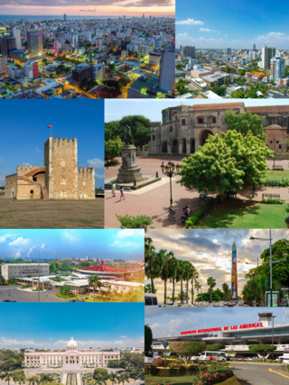
Santo Domingo, once known as Santo Domingo de Guzmán, known as Ciudad Trujillo between 1936 and 1961, is the capital and largest city of the Dominican Republic and the largest metropolitan area in the Caribbean by population. As of 2022, the city and immediate surrounding area had a population of 1,029,110 while the total population is 3,798,699 when including Greater Santo Domingo. The city is coterminous with the boundaries of the Distrito Nacional, itself bordered on three sides by Santo Domingo Province.

Dominicans are people identified with the country of Dominican Republic. This connection may be residential, legal, historical or cultural. For most Dominicans, many of these connections exist and are collectively the source of their being Dominican.

Underwater habitats are underwater structures in which people can live for extended periods and carry out most of the basic human functions of a 24-hour day, such as working, resting, eating, attending to personal hygiene, and sleeping. In this context, 'habitat' is generally used in a narrow sense to mean the interior and immediate exterior of the structure and its fixtures, but not its surrounding marine environment. Most early underwater habitats lacked regenerative systems for air, water, food, electricity, and other resources. However, some underwater habitats allow for these resources to be delivered using pipes, or generated within the habitat, rather than manually delivered.

The Tibes Indigenous Ceremonial Center in Sector La Vega de Taní, Barrio Tibes, Ponce, Puerto Rico, houses one of the most important archaeological discoveries made in the Antilles. The discovery provides an insight as to how the indigenous tribes of the Igneri and Taínos lived and played during and before the arrival of Christopher Columbus to the New World. Tibes is the oldest Antillean Indian ceremonial and sports complex yet uncovered in Puerto Rico. Within its boundaries is also the largest indigenous cemetery discovered to date – consisting of 186 human skeletons, most from the Igneri and the rest from the pre-Taíno cultures. Based on the orientation of the ceremonial plazas, this is also believed to be the oldest astronomical observatory in the Antilles. The museum was established in 1982 and restored in 1991.

Saona Island is a 110 square kilometer tropical island located off the south-east coast in Dominican Republic's La Altagracia province. It is a government-protected nature reserve and is part of Parque Nacional Cotubanamá.

The Abrolhos Marine National Park is a national park that was established in 1983 covering most of the Abrolhos Archipelago area in the state of Bahia, Brazil.
Jaragua National Park is a Dominican national park located in Pedernales Province, in the extreme southwest of the Dominican Republic. Jaragua has a total area of 1,374 km², the largest such protected area in the Caribbean.

Ciudad Colonial is the historic central neighborhood of the Dominican Republic's capital Santo Domingo. It is the oldest continuously inhabited European-established settlement in the Americas. The area has been declared a World Heritage Site by UNESCO. It is also known as Zona Colonial or more colloquially as "La Zona".

Bayahíbe is a town in the Dominican Republic, located about 10 miles (16 km) east of La Romana on the shore of the Caribbean Sea with 5,618 inhabitants (2022). Founded as a fishing village in 1874 by Juan Brito and his family, who came from Puerto Rico, the town is now a tourist destination.
Pedro José Borrell Bentz is an internationally recognized Dominican architect and archeologist who has earned several awards and is recognized for the transcendence in his architectural designs.
Jason deCaires Taylor is a British sculptor and creator of the world's first underwater sculpture park – the Molinere Underwater Sculpture Park – and underwater museum – Cancún Underwater Museum (MUSA). He is best known for installing site-specific underwater sculptures that develop naturally into artificial coral reefs, which local communities and marine life depend on. Taylor integrates his skills as a sculptor, marine conservationist, underwater photographer and scuba diving instructor into each of his projects. By using a fusion of Land Art traditions and subtly integrating aspects of street art, Taylor produces dynamic sculptural works that are installed on the ocean floor to encourage marine life, to promote ocean conservation and to highlight the current climate crisis.

La Caleta is a small community located in the Santo Domingo Province of the Dominican Republic. La Caleta obtained its name from its origins as a small cove. It was elevated to Municipal District by Law 107-04, dated 16 July 2004, in the municipality of Boca Chica.

Tourism in the Dominican Republic is an important sector of the country's economy. More than 10 million tourists visited the Dominican Republic in 2023, making it the most popular tourist destination in the Caribbean and putting it in the top 5 overall in the Americas. The industry accounts for 11.6% of the nation's GDP and is a particularly important source of revenue in coastal areas of the country. The nation's tropical climate, white sand beaches, diverse mountainous landscape and colonial history attracts visitors from around the world. In 2022, the nation's tourism was named the best-performing nation post-pandemic with over 5% visitors more in comparison to pre-pandemic levels in 2019.

The Pedra da Risca do Meio Marine State Park is a state park in the state of Ceará, Brazil.

Three Bays Protected Area, also known as Three Bays National Park, is a protected area in northeastern Haiti. It protects coral reefs, seagrass beds, mangrove forests, and dry forests.
Kathleen Teresa Martínez Berry is a Dominican lawyer, archaeologist, and diplomat, best known for her work since 2005 in the search for the tomb of Cleopatra in the Taposiris Magna temple in Egypt. She heads the Egyptian-Dominican mission in Alexandria and is currently minister counselor in charge of cultural affairs at the Dominican embassy in Egypt.

The Taíno were the Indigenous people of the Caribbean and the principal inhabitants of Cuba, the Dominican Republic, Haiti, Jamaica, and Puerto Rico. Caribbean archaeologists have theorized that by the mid 16th century the native people of the Caribbean were extinct. However, the story of Taino extinction may not be the case according to recent research and archaeological findings.

Cotubanamá National Park is located on the lower southeastern coast of the Dominican Republic, spanning across the provinces of La Altagracia and La Romana with an area of 791.9 sq. kilometers which includes a range of dense humid and dry subtropical forests, mangroves, beaches, and caves.

