The montaña del Príncipe Pío is a hill in the western part of Madrid, Spain.

The Buen Retiro Park, Retiro Park or simply El Retiro is one of the largest parks of the city of Madrid, Spain. The park belonged to the Spanish Monarchy until the late 19th century, when it became a public park.

The Walls of Lima were a fortification consisting mainly of walls and bastions whose purpose was to defend the city of Lima from exterior attacks. It was built between 1684 and 1687, during the Viceroy Melchor de Navarra y Rocafull 's government.

The Paseo del Prado is one of the main boulevards in Madrid, Spain. It runs north–south between the Plaza de Cibeles and the Plaza del Emperador Carlos V, with the Plaza de Cánovas del Castillo lying approximately in the middle. The Paseo del Prado forms the southern end of the city's central axis. It enjoys the status of Bien de Interés Cultural (BIC), and as part of a combined UNESCO World Heritage Site with Buen Retiro Park.
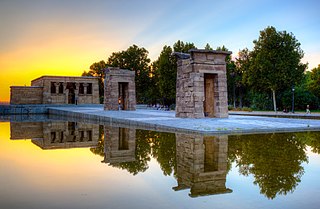
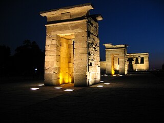
The Temple of Debod is an ancient Egyptian temple that was dismantled as part of the International Campaign to Save the Monuments of Nubia and rebuilt in the center of Madrid, Spain, in Parque de la Montaña, Madrid, a square located Calle de Irún, 21–25 Madrid.

The Casa de Campo is the largest public park in Madrid. It is situated west of central Madrid, Spain. It gets its name 'Country House' because it was once a royal hunting estate, located just west of the Royal Palace of Madrid. It was created in the early 16th century for use by the royal family and nobility, and was opened to the public in 1931 when it became a public park. Today, it is a popular green space and weekend destination for Madrid residents.
Polanco is a neighborhood in the Miguel Hidalgo borough of Mexico City. Polanco is an affluent colonia, noted for its luxury shopping along Presidente Masaryk Avenue, the most expensive street in Mexico, as well as for the numerous prominent cultural institutions located within the neighborhood.

The Naguanagua municipality is one of the 14 municipalities (municipios) that makes up the Venezuelan state of Carabobo and, according to the 2011 census by the National Institute of Statistics of Venezuela, the municipality has a population of 157,437. The town of Naguanagua is the shire town of the Naguanagua Municipality. It forms part of the greater Valencia Metropolitan Area in Venezuela. It is in the valley of the Cabriales River at the base of Cerro El Café and the El Trigal Mountain. Valencia and Naguanagua form a continuous urban area. The highway that runs from the centre of Valencia towards Puerto Cabello passes through this community; Bolivar Avenue in Valencia becomes University Avenue in Naguanagua on the northern side of a traffic roundabout, or redoma.

The Rock 'n' Roll Madrid Marathon is an annual marathon race which takes place in Madrid, Spain, in late April. The event was first held in 1978 and has since gained IAAF Gold Label Road Race status and had over 15,000 runners participate in the 2017 edition. A 10 km road race was added in 2010 and a Half Marathon road race was added in 2012.

Moncloa-Aravaca is a district of the municipality of Madrid, Spain. It is located to the northwest of the city centre, spanning across both banks of the Manzanares. It is made up of the neighborhoods of Aravaca, Argüelles, Casa de Campo, Ciudad Universitaria, El Plantío, Valdemarín and Valdezarza.
The Battle of Ciudad Universitaria was a belligerent confrontation at the start of the defense of Madrid in the Spanish Civil War. This battle happened in the new campus area of the Ciudad Universitaria from 15 to 23 November 1936 leaving a stable front until the end of the war. The republican militias' objective was "the defense of the capital at all costs", and for that, it was necessary to stop the advance of general Valera's troops and the fall of Madrid. On the other side, the attackers had as an objective to "conquer the city" as fast as possible. The persistence and tenacity of both sides in the battle meant an inflection point on the Spanish Civil War, partly because it was the first time that Franco's troops were stopped. The campus was also one of the most long-lasting confrontation points during the Spanish Civil War. The resistance shown in Madrid raised the morality of other fronts amongst the Gobierno de la República's controlled zone. The end of the battling period on 23 November 1936 was because of a change in strategy on part of the attackers. Between the main characteristics of this confrontation, it is worth mentioning the entrance to battle, for the first time in this war, of the varied troops that belonged to the International Brigades, just like the heavy military material of Soviet origins. The attackers received material and troops from Germany and Italy, being also one of the first times in history in which aerial bombing against the civil population was used.

The Teleférico de Madrid, or Madrid Cable Car, is a gondola lift in the Spanish capital city of Madrid. It is 2,457 metres (8,061 ft) long and links the Parque del Oeste with the Casa de Campo. The line was built by Von Roll and opened in 1969. It uses 72 six-seater cabins, which take 11 minutes to travel the full length of the line.

Puerta del Ángel is a station on Line 6, located beneath the Paseo de Extremadura near the Puente de Segovia in the district of Latina. It is located in fare Zone A. The station is named after the Puerta del Ángel neighborhood, which is in turn named after a former access gate to the Casa de Campo park.
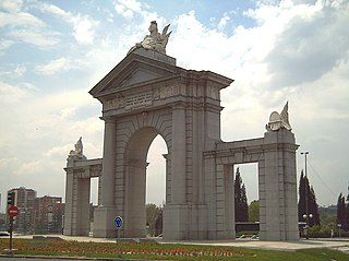
The Puerta de San Vicente is a monumental gate located in the Glorieta de San Vicente in Madrid (Spain). Since 1995, it has occupied the space where the original door, designed by architect Francesco Sabatini, was located between 1775 and 1892.

The Monument to Lieutenant General Manuel Cassola is an instance of public art in Madrid, Spain. It consists of a bronze statue of Manuel Cassola designed by Mariano Benlliure topping off a stone pedestal.