Paruro | |
|---|---|
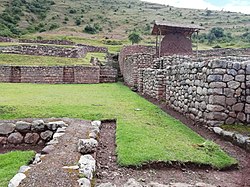 Archaeological site of Maucallacta in the Paccaritambo District | |
 Flag | |
 Location of Paruro in the Cusco Region | |
| Country | Peru |
| Region | Cusco |
| Capital | Paruro |
| Government | |
| • Mayor | Adolfo Santiago Fernandez Baca Loaiza (2007) |
| Area | |
• Total | 1,984.42 km2 (766.19 sq mi) |
| Population (2005 census) | |
• Total | 32,244 |
| • Density | 16/km2 (42/sq mi) |
| UBIGEO | 0810 |
Paruro is one of thirteen provinces in the Cusco Region in the southern highlands of Peru.
Contents
The provincial capital of Paruro, with a population of 3,855, lies at 3,057 meters (10,032 ft) altitude. [1] Two and a half hours by bus from Cusco, at the bottom of a deep valley, it is bordered on one side by the Rio Paruro, a feeder of the Apurímac River. A number of small Inca and pre-Inca ruins are in the area, and a series of arches was built by Simón Bolívar to celebrate a victory over the Spaniards.
Nearby Paqariq Tampu is one of the legendary origin sites of Manqu Qhapaq and Mama Uqllu, founders of the Inca Empire.