Pass of Drumochter

Last updated • 2 min readFrom Wikipedia, The Free Encyclopedia

Pass of Drumochter from the south. March 2007 Drumochter March2007.jpg
Pass of Drumochter from the south. March 2007
Image of the road in winter. February 2005 DrumochterPass.jpg
Image of the road in winter. February 2005

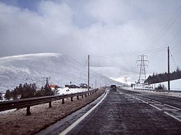
The Pass of Drumochter (Scottish Gaelic : Druim Uachdair) [1] meaning simply 'high ridge' is the main mountain pass between the northern and southern central Scottish Highlands. The A9 road passes through here, as does the Highland Main Line, the railway between Inverness and the south of Scotland. The Sustrans National Cycle Route 7 between Glasgow and Inverness also runs through the pass.

The pass is the only gap in the main Grampian Watershed suitable for road traffic routes for almost 100 km, between Glen Coe (west) and Cairnwell Pass (east); the West Highland Railway is the only other crossing, at Corrour. The pass is a natural low point, where the headwaters of the Spey and Tay penetrate most deeply into the broad Gaick Plateau, with the River Garry flowing south, and the River Truim north. The gap has been shaped into a "U" convenient for a transport corridor by glacial action over successive ice ages, although Loch Ericht just to the west is a much larger glacial breach. [2] [3]

The route through the pass has been used since prehistoric times. A military road built between 1728 and 1730 by General Wade came through here.

It is the high point on the A9, at 460 m (1508 ft), and in winter can be subject to severe weather conditions. There are routine winter patrols from November to March, and the road is occasionally closed with snow gates near Dalwhinnie and Dalnacardoch. The summit of the railway line is 452 m (1480 ft), making it the highest in the UK. It has been used by the RAF as a training route for low level flying, now less frequently.

Train near Drumochter Summit in 1957 Drumochter Summit 2064580 428eeeb2.jpg
Train near Drumochter Summit in 1957

It is isolated, and the nearest settlement of any size is the small village of Dalwhinnie, some 10 km (6 mi) to the north.

The summit of the pass marks the boundary between Perth and Kinross and the Highland Council area. A sign at this point says "Welcome to the Highlands/Fàilte don Ghàidhealtachd", although this is the boundary for the authority rather than for the Scottish Highlands which extend south to the geological Highland Boundary Fault at Dunkeld.

Related Research Articles

<span class="mw-page-title-main">Scottish Highlands</span> Cultural and historical region of Scotland

The Highlands is a historical region of Scotland. Culturally, the Highlands and the Lowlands diverged from the Late Middle Ages into the modern period, when Lowland Scots language replaced Scottish Gaelic throughout most of the Lowlands. The term is also used for the area north and west of the Highland Boundary Fault, although the exact boundaries are not clearly defined, particularly to the east. The Great Glen divides the Grampian Mountains to the southeast from the Northwest Highlands. The Scottish Gaelic name of A' Ghàidhealtachd literally means "the place of the Gaels" and traditionally, from a Gaelic-speaking point of view, includes both the Western Isles and the Highlands.

<span class="mw-page-title-main">A9 road (Scotland)</span> Major road in Scotland

The A9 is a major road in Scotland running from the Falkirk council area in central Scotland to Scrabster Harbour, Thurso in the far north, via Stirling, Bridge of Allan, Perth and Inverness. At 273 miles (439 km), it is the longest road in Scotland and the fifth-longest A-road in the United Kingdom. Historically it was the main road between Edinburgh and John o' Groats, and has been called the spine of Scotland. It is one of the three major north–south trunk routes linking the Central Belt to the Highlands – the others being the A82 and the A90.

<span class="mw-page-title-main">Mounth</span> Mountainous region in Scotland

The Mounth is the broad upland in northeast Scotland between the Highland Boundary and the River Dee, at the eastern end of the Grampians.

<span class="mw-page-title-main">Cairngorms</span> Mountain range in the eastern Highlands of Scotland

The Cairngorms are a mountain range in the eastern Highlands of Scotland closely associated with the mountain Cairn Gorm. The Cairngorms became part of Scotland's second national park on 1 September 2003. Although the Cairngorms give their name to, and are at the heart of, the Cairngorms National Park, they only form one part of the national park, alongside other hill ranges such as the Angus Glens and the Monadhliath, and lower areas like Strathspey.

<span class="mw-page-title-main">Grampian Mountains</span> Mountain range in Scotland

The Grampian Mountains is one of the three major mountain ranges in Scotland, that together occupy about half of Scotland. The other two ranges are the Northwest Highlands and the Southern Uplands. The Grampian range extends northeast to southwest between the Highland Boundary Fault and the Great Glen. The range includes many of the highest mountains in the British Isles, including Ben Nevis and Ben Macdui.

<span class="mw-page-title-main">Great Glen</span> Scottish valley along geological fault line

The Great Glen, also known as Glen Albyn or Glen More, is a glen in Scotland running for 62 miles (100 km) from Inverness on the edge of the Moray Firth, in an approximately straight line to Fort William at the head of Loch Linnhe. It follows a geological fault known as the Great Glen Fault, and bisects the Scottish Highlands into the Grampian Mountains to the southeast and the Northwest Highlands to the northwest.

<span class="mw-page-title-main">Highland Main Line</span> Railway line in Scotland

The Highland Main Line is a railway line in Scotland. It is 118 mi (190 km) long and runs through the central Scottish Highlands, mainly following the route of the A9, and linking a series of small towns and villages with Perth at one end and Inverness at the other. Today, services between Inverness and Edinburgh, Glasgow and London use the line. At Inverness the line connects with the Far North Line, the Aberdeen-Inverness Line and the Kyle of Lochalsh Line. Since the line is not electrified all trains are diesel-powered.

<span class="mw-page-title-main">Loch Ericht</span> Freshwater loch in the Highlands of Scotland

Loch Ericht is a freshwater loch on the border between the former Perthshire, now Perth and Kinross and the former Inverness-shire, now Highlands Council areas of Scotland. It has a north-east to south-west orientation. The village of Dalwhinnie lies at the north east end of the loch. Loch Ericht is the tenth largest freshwater lake in Scotland and has a good reputation for its trout fishing and Ferox trout.

<span class="mw-page-title-main">Dalwhinnie</span> Human settlement in Scotland

Dalwhinnie is a small village in the Scottish Highlands. Dalwhinnie is located at the head of Glen Truim and the north-east end of Loch Ericht, on the western edge of the Cairngorms National Park.

<span class="mw-page-title-main">Slochd Summit</span> Summit in Highland, Scotland, UK

The Slochd Summit is a mountain pass on the A9 road and the Highland Main Line Railway in the Scottish Highlands between Inverness and Aviemore. An old military road also goes through the pass. National Cycle Network route 7 also goes over the summit, largely following the old A9.

National Cycle Route 7 is a route of the United Kingdom National Cycle Network, running from Sunderland to Inverness.

<span class="mw-page-title-main">Sgairneach Mhòr</span>

Sgairneach Mhòr is a Scottish mountain which lies in a group of seven Munros near the summit of the Pass of Drumochter and are known as the Drumochter mountains or informerly as the “A9 Munros”. The mountain is situated 13 km SSW of Dalwhinnie and four km east of the large Loch Ericht.

<span class="mw-page-title-main">A' Mharconaich</span> 973m high mountain in the Scottish Highlands

A' Mharconaich is a mountain near Dalwhinnie in the Scottish Highlands. It is a Munro with a height of 975 metres (3,199 ft). It is in a group of mountains east of Loch Ericht and west of the A9 road and Pass of Drumochter, and are known accordingly as the Drumochter Hills. A' Mharconaich is just within the Cairngorms National Park although it is not part of the Cairngorms mountains.

<span class="mw-page-title-main">A' Bhuidheanach Bheag</span>

A' Bhuidheanach Bheag is a Scottish mountain situated on the eastern side of the Pass of Drumochter, some 24 km WNW of Blair Atholl. The mountain straddles the border between Highland and Perth and Kinross council areas although the actual summit is in the latter.

<span class="mw-page-title-main">The Sow of Atholl</span>

The Sow of Atholl is a Scottish hill which is situated 27 kilometres west-northwest of the town of Blair Atholl in Perth and Kinross council area. It stands on the western side of the Pass of Drumochter in a group of hills which lie around Coire Dhomhain.

<span class="mw-page-title-main">Beinn Udlamain</span> Scottish mountain

Beinn Udlamain is a Scottish mountain which stands just to the west of the summit of the Pass of Drumochter and east of Loch Ericht, some 30 km west-northwest of the village of Blair Atholl. The mountain’s summit stands on the border between the Highland and Perth and Kinross council areas.

<span class="mw-page-title-main">River Truim</span> Right bank tributary of the River Spey in the Scottish Highlands

The River Truim is a right bank tributary of the River Spey in the Scottish Highlands. Its headwaters meet to the north of the Pass of Drumochter and flow northwards as the Truim past the dam at the northern end of Loch Ericht and through the village of Dalwhinnie, highest village in the Scottish Highlands. The distillery at Dalwhinnie producing Dalwhinnie Single Malt is also the highest in Scotland. The waters of its most significant tributary, the Allt Cuaich, are diverted in part along an aqueduct to Loch Ericht. The river continues north-northeastwards down Glen Truim, over the Falls of Truim and on to meet the Spey 2.5 miles (4 km) southwest of Newtonmore. It is closely followed for almost its entire length by both the A9 road and the mainline railway from Perth to Inverness.

<span class="mw-page-title-main">River Garry, Perthshire</span>

The River Garry is a major tributary of the River Tummel, itself a tributary of the River Tay, in the traditional county of Perthshire in the Scottish Highlands. It emerges from the northeastern end of Loch Garry (56.8193°N 4.2311°W), just to the southeast of the Pass of Drumochter, and flows southeastwards and eastwards down Glen Garry to the narrow Pass of Killiecrankie beyond which it joins the Tummel (56.7182°N 3.7790°W).

<span class="mw-page-title-main">Military roads of Scotland</span> Road network created in the wake of the Jacobite rebellions

A network of military roads, sometimes called General Wade's Military Roads, was constructed in the Scottish Highlands during the middle part of the 18th century in the wake of the Jacobite rebellion of 1715.

<span class="mw-page-title-main">Dava Way</span> Trail in Moray, Scotland, UK

The Dava Way is a 38 km (24 mi) long-distance path that mostly follows the route of the former Highland Railway between Grantown and Forres. The railway line, built as a route between Inverness and Perth, opened in 1863 and closed in 1965. The route was reopened as a long distance path in 2005. It is listed as one of Scotland's Great Trails by NatureScot, and links directly to two further Great Trails: the Moray Coast Trail and the Speyside Way. It is currently the shortest of the Great Trails, but can be combined with sections of the Moray Coast Trail and Speyside Way to form a 153 km (95 mi) circular route known as the Moray Way. About 5,000 people use the path every year, of whom about 400 complete the entire route.

References

  1. Drummond, Peter; Stewart, Donald William (1991). Scottish Hill and Mountain Names: The Origin and Meaning of the Names of Scotland's Hills and Mountains. Scottish Mountaineering Trust. p. 89. ISBN   9780907521303.
  2. D. Linton, Watershed breaching by ice, Transactions of the Institute of British Geographers 1949, 15, 1-16
  3. Hall AM and Jarman D (2004): Quaternary landscape evolution – plateau dissection by glacial breaching. In The Quaternary of the Central Grampian Highlands - Field Guide (edited by S. Lukas, J. Merritt, W. Mitchell). Quaternary Research Association, London, 26-40.

56°51′35″N4°14′55″W / 56.85964°N 4.24856°W / 56.85964; -4.24856