Route 3 is a major state highway in the northeastern part of New Jersey. The route runs 10.84 miles (17.45 km) from U.S. Route 46 (US 46) in Clifton, Passaic County to US 1/9 in North Bergen, Hudson County. The route is a divided highway for its entire length, and intersects many major roads, including US 46, which takes travelers to Interstate 80 (I-80) west for commuting out of the city-area, Garden State Parkway and Route 21 in Clifton, Route 17 and the Western Spur of the New Jersey Turnpike (I-95) in East Rutherford, the Eastern Spur of the New Jersey Turnpike in Secaucus, and Route 495 in North Bergen, for traffic going to the Lincoln Tunnel into New York City. Route 3 serves as the main artery to the Lincoln Tunnel from I-80, in conjunction with a portion of US 46 and Route 495. Portions of the route are not up to interstate highway or freeway standards; with businesses, bus stops, and narrow lanes. Despite this, many construction projects over the years have been underway to alleviate this issue. Route 3 also provided access to Hoffmann La Roche's former American headquarters in Nutley, the Meadowlands Sports Complex and American Dream Meadowlands in East Rutherford. The road inspired a story in The New Yorker in 2004 by Ian Frazier due to its views of the Manhattan skyline. Route 3 was originally the Lincoln Tunnel Approach and ended at the state line in the Hudson River, though it was scaled back following the construction of I-495; which is now Route 495 due to also not meeting interstate highway standards.
Route 20, known locally as McLean Boulevard, is a state highway that runs 4.15 miles (6.68 km) in New Jersey, United States. It runs along the east side of Paterson, Passaic County, following the west bank of the Passaic River between U.S. Route 46 and River Street, at which point County Route 504 begins. It is a four- to six-lane divided highway for most of its length that runs through residential and commercial areas of Paterson, intersecting with Interstate 80 and Route 4 at interchanges. The northernmost part of the route is a county-maintained one-way pair that follows 1st and 2nd Avenues.
Passaic is a city in Passaic County, New Jersey, United States. As of the 2020 United States Census, the city had a total population of 70,537, ranking as the 16th largest municipality in New Jersey. Among cities with more than 50,000 people, Passaic is the fifth-most-densely-populated municipality in the United States, with more than 22,000 people per square mile.
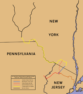
The New York, Susquehanna and Western Railway is a Class II American freight railway operating over 400 miles (645 km) of track in the northeastern U.S. states of New York, Pennsylvania, and New Jersey.

The Main Line is a commuter rail line owned and operated by New Jersey Transit running from Suffern, New York to Hoboken, New Jersey, in the United States. It runs daily commuter service and was once the north–south main line of the Erie Railroad. It is colored yellow on NJ Transit system maps, and its symbol is a water wheel.

The Bergen County Line is a commuter rail line and service owned and operated by New Jersey Transit in the U.S. state of New Jersey. The line loops off the Main Line between the Meadowlands and Glen Rock, with trains continuing in either direction along the Main Line. It is colored on NJT system maps in grey, and its symbol is a cattail, which are commonly found in the Meadowlands where the line runs.
New Jersey's 9th congressional district is represented in Congress by Democrat Bill Pascrell, who resides in Paterson. Congressman Pascrell was first elected in 1996 from the old 8th district, defeating incumbent William J. Martini. The 9th district consists largely of municipalities in Bergen County and Passaic County.
Paterson Plank Road is a road that runs through Passaic, Bergen and Hudson Counties in northeastern New Jersey. The route, originally laid in the colonial era, connects the city of Paterson and the Hudson River waterfront. It has largely been superseded by Route 3, but in the many towns it passes it has remained an important local thoroughfare, and in some cases been renamed.

Downtown Paterson is the main commercial district of Paterson, Passaic County, New Jersey, United States. The area is the oldest part of the city, along the banks of the Passaic River and its Great Falls. It is roughly bounded by Interstate 80, Garret Mountain Reservation, Route 19, Oliver Street, and Spruce Street on the south; the Passaic River, West Broadway, Cliff Street, North 3rd Street, Haledon Avenue, and the borough of Prospect Park on the west; and the Passaic River also to the north.

Kingsland is a railroad station on New Jersey Transit's Main Line. It is located under Ridge Road (Route 17) between New York and Valley Brook Avenues in Lyndhurst, New Jersey, and is one of two stations in Lyndhurst. The station is not staffed, and passengers use ticket vending machines (TVMs) located at street level to purchase tickets. The station is not handicapped-accessible. Originally part of the Delaware, Lackawanna and Western Railroad's Boonton Branch, the current Kingsland station was built in 1918.

Paterson is a New Jersey Transit commuter rail train station located on an elevated viaduct above Market Street in downtown Paterson, New Jersey. The railway through the station is double tracked, for north and south traffic on the NJT Main Line.
The Jersey City, Hoboken and Rutherford Electric Railway was incorporated in 1893, and leased from 1894-1899 to the New Jersey Electric Railway Company. The line was operated by Jersey City, Hoboken and Paterson Street Railway. The track length was 18.57 miles.
The Passaic, Rutherford and Carlstadt Electric Railway was a trolley line incorporated in 1889 and consolidated into the Paterson, Passaic and Rutherford Electric Railway in 1893.

Paterson City Hall is located at 155 Market Street in Paterson, Passaic County, New Jersey. The building is located on a block in Downtown Paterson bordered by Market Street on the north, Colt Street to the east, Ellison Street to the south, and Washington Street to the west.

Carlton Hill station was a railroad station for the Erie Railroad in East Rutherford, New Jersey, United States. Carlton Hill station was the second station along the Erie's main line and the first station after Rutherford Junction, where the Erie's main line forked from the Bergen County Railroad. The station provided service for passengers in Rutherford and East Rutherford's Carlton Hill district and freight billing for the Royce Chemical Company, producer of Royox household cleaner, epoxies and dyes.
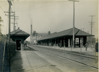
Passaic station was a railroad station for the Erie Railroad in downtown Passaic, New Jersey. The station sat in the center of Main Street at the corner of Madison Street. Though there were three other stations in the city — Prospect Street and Passaic Park to the east, and Harrison Street to the west — the simply named Passaic station was the primary station for the city, located at grade in the busiest section of its main business street.

Clifton was a former train station for the Erie Railroad and Erie-Lackawanna Railroad in the city of Clifton, Passaic County, New Jersey, United States. Located at the intersection of Getty Avenue and Clifton Avenue, the station served as part of the Main Line. The station consisted of tracks on an elevated line above Getty Avenue with the 1952-built station depot on the side. After the closure of Harrison Street station, the station to the southeast was Passaic and the next station to the northwest was the Lake View station in nearby Paterson.
