Related Research Articles
Quill Lake is a village in the Canadian province of Saskatchewan within the Rural Municipality of Lakeside No. 338 and Census Division No. 10. It is 170 km east of Saskatoon and 200 km northeast of Regina.
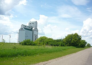
Beatty is a village in the Canadian province of Saskatchewan within the Rural Municipality of Flett's Springs No. 429 and Census Division No. 15. The village is located approximately 13 km (8 mi) northwest of the City of Melfort. It is at the junction of Highway 3 and Highway 368. In 1925, Beatty was a Canadian National Railways (CNR) rail station on the Swan River - Prince Albert branch line. The area surrounding Beatty is predominantly farmland and the main source of employment is agriculture.

St. Brieux is a town in the Canadian province of Saskatchewan. It is located near Highway 368 and Highway 779. St. Brieux is located north of the village of Lake Lenore on the eastern shore of St. Brieux Lake. St. Brieux Regional Park and Golf Course is adjacent to the west side of the town.

Leroy is a town in the province of Saskatchewan, Canada.

White Bear is an unincorporated community in the Rural Municipality of Lacadena No. 228, Saskatchewan, Canada. Listed as a designated place by Statistics Canada, the hamlet had a population of 15 in the Canada 2006 Census. The community is approximately 55 mi (89 km) northwest of Swift Current on the north side of the South Saskatchewan River.
Lake Lenore is a village in the Canadian province of Saskatchewan within the Rural Municipality of St. Peter No. 369 and Census Division No. 15. The village is located 144 kilometres (89 mi) northeast of the city of Saskatoon. To the north of the village is Lenore Lake, which is designated as a migratory bird sanctuary, an Important Bird Area (IBA) of Canada, and has a National Wildlife Area on Raven Island. Services in Lake Lenore include a school, Co-op Grocery and Agro Service Station, a Credit Union, and Public Library.

Osler is a town in the Canadian province of Saskatchewan, founded in the 1890s. The community was named after Sir Edmund Boyd Osler (1845–1924), who was an Ontario-based explorer, railroad financier, and Member of Parliament.

Beaubier is a hamlet in the Canadian province of Saskatchewan. The community was renamed Beaubier to honour a young schoolteacher who died nursing the ill during the 1918 Spanish flu pandemic.
Delmas is a hamlet in the Rural Municipality of Battle River No. 438, Saskatchewan, Canada. Listed as a designated place by Statistics Canada, the hamlet had a population of 128 in the Canada 2016 Census. The hamlet is located approximately 32.6 kilometres (20.3 mi) west of North Battleford on Highway 16.
Hendon is a hamlet in the Rural Municipality of Lakeview No. 337, Saskatchewan, Canada. Listed as a designated place by Statistics Canada, the hamlet had a population of 20 in the Canada 2016 Census.
Kronau is a hamlet in the Canadian province of Saskatchewan located 28 km south east of Regina on Highway 33 in the R.M. of Lajord No. 128, Saskatchewan. Listed as a designated place by Statistics Canada, the hamlet had a population of 209 in the Canada 2006 Census.
Kuroki is a hamlet in the Rural Municipality of Sasman No. 336, Saskatchewan, Canada. Listed as a designated place by Statistics Canada, the hamlet had a population of 50 in the Canada 2016 Census. The community is named after the Japanese general Kuroki Tamemoto.
North Shore Fishing Lake is a hamlet in the Rural Municipality of Sasman No. 336, Saskatchewan, Canada. Listed as a designated place by Statistics Canada, the hamlet had a population of 50 in the Canada 2016 Census. It is located on the north-eastern shore of Fishing Lake.
Ottman-Murray Beach is a hamlet in the Canadian province of Saskatchewan. Listed as a designated place by Statistics Canada, the hamlet had a population of 15 in the Canada 2016 Census. It is located on the eastern shore of Fishing Lake.
Riceton is a hamlet in the Canadian province of Saskatchewan.

Wymark is a hamlet in Swift Current Rural Municipality No. 137, Saskatchewan, Canada. Listed as a designated place by Statistics Canada, the hamlet had a population of 144 in the Canada 2006 Census. The hamlet is located on Highway 628 about 2 km north of Highway 363, and 15 km south of Swift Current. When the existing railway was extended to branch off in another direction, a town formed at this junction. This "Y" formation of the railway, resulted in the town being named Wymark.

The Rural Municipality of Lake Alma No. 8 is a rural municipality (RM) in the Canadian province of Saskatchewan within Census Division No. 2 and SARM Division No. 2. Located in the southeast portion of the province, it is adjacent to the United States border, neighbouring Sheridan County in Montana and Divide County in North Dakota.
Stranraer is an unorganized hamlet located in the Rural Municipality of Mountain View No. 318 in Saskatchewan on Highway 31 and along a now abandoned section of the Kerrobert-Rosetown Canadian Pacific Railway line. The community is along the course of Eagle Creek.

Cando is a hamlet in Rosemount Rural Municipality No. 378, Saskatchewan, Canada. In 2006 the village had a population of 68 people. It previously held the status of village until December 31, 2005. The hamlet is located 48 km south of the City of North Battleford on highway 4. The community was served by Canadian National Railway's Porter Subdivision. The rail line was originally built by the Grand Truck Pacific from Oban to Battleford. The community is situated along the remains of the historic Swift Current-Battleford Trail. The portion of the line from Battleford to Cando was closed in 1974, leaving the portion to Cando from Oban. Once the elevator at Cando closed the remainder of the line was abandoned in the late 1980s.
References
- ↑ Canada 2006 Census: Designated places in Saskatchewan
- ↑ City & Town: Saskatchewan
- ↑ "Canadian Mining Journal - Daily News". Archived from the original on 2015-09-08. Retrieved 2015-09-06.
- ↑ The Encyclopedia of Saskatchewan: Population Trends
52°43′00″N104°48′02″W / 52.71667°N 104.80056°W
| | This article about a location in the Census Division No. 15 of Saskatchewan is a stub. You can help Wikipedia by expanding it. |