Paul Chiasson

Last updated

Paul Chiasson is a Canadian architect (M.Arch. Yale '81) author, who has written pseudohistories about the settlement of North America. [1] [2]

Contents

In his first book, The Island of Seven Cities: Where the Chinese Settled When They Discovered America, [3] Chiasson explains his belief that Chinese voyagers settled in the Cape Dauphin area of Nova Scotia almost a century before the voyages of Christopher Columbus. He suggests that the indigenous Mi'kmaq culture was influenced by these people in the form of possible archaeological remains, customs, costumes, art and even written language.
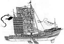
A large junk ship, 18th century. Chaisson argued that a vessel such as this may have arrived as part of the Ming treasure voyages. A 18th century Nanjing ship or sand ship from Tosen no Zu.jpg
A large junk ship, 18th century. Chaisson argued that a vessel such as this may have arrived as part of the Ming treasure voyages.

His theory has been rejected by mainstream historians. [1] Provincial archaeologists and a geologist have said that some of Chiasson's physical evidence of a Chinese settlement—a road up the side of Cape Dauphin and the stone remains of a wall surrounding the site —were actually built in 1952 by a volunteer fire company fighting a forest fire and again in the 1990s by a gravel company attempting to dig gravel on the cape. [4] Chiasson challenges these statements in his second book, Written in the Ruins: Cape Breton Island's Second Pre-Columbian Chinese Settlement. [5]

In December 2010, several years after the reports of the Nova Scotian archeologists, History Television aired a one-hour documentary entitled "Mysterious Ruins: Cape Breton". [6] The documentary explored Chiasson's theory and included interviews with an archeologist and a geologist from the area who viewed the site that Chiasson posits was the location of a pre-Columbian Chinese community. Geologist Sandra Barr of Acadia University and archaeologist Steve Davis of St. Mary's University stated that they found no evidence of any human settlement on the site. Acadia University reported that "their explanations are mostly ignored in the film." [7] The documentary also included interviews with several Chinese architectural historians. [8] Dr. Zhu Guangya, Professor of Architectural History at Southeast University, Nanjing stated (translation), "I believe the site is a ruin from a human settlement. Further study is required to confirm what kind of settlement it is."[ citation needed ] Professor Fang Yong said that "I feel that what he has found is not yet enough to prove that it is ruins of a Chinese settlement, but it is possible.” [8]

See also

Related Research Articles

<span class="mw-page-title-main">The Maritimes</span> Region of Atlantic Canada

The Maritimes, also called the Maritime provinces, is a region of Eastern Canada consisting of three provinces: New Brunswick, Nova Scotia, and Prince Edward Island. The Maritimes had a population of 1,813,606 in 2016, which makes up 5.6% of Canada's population. Together with Canada's easternmost province, Newfoundland and Labrador, the Maritime provinces make up the region of Atlantic Canada.

<span class="mw-page-title-main">Nova Scotia</span> Province of Canada

Nova Scotia is one of the thirteen provinces and territories of Canada. It is one of the three Maritime provinces and one of the four Atlantic provinces. Nova Scotia is Latin for "New Scotland".

<span class="mw-page-title-main">Acadia</span> Colony of New France in northeastern North America

Acadia was a colony of New France in northeastern North America which included parts of what are now the Maritime provinces, the Gaspé Peninsula and Maine to the Kennebec River. During much of the 17th and early 18th centuries, Norridgewock on the Kennebec River and Castine at the end of the Penobscot River were the southernmost settlements of Acadia. The French government specified land bordering the Atlantic coast, roughly between the 40th and 46th parallels. It was eventually divided into British colonies. The population of Acadia included the various indigenous First Nations that comprised the Wabanaki Confederacy, the Acadian people and other French settlers.

<span class="mw-page-title-main">Fortress of Louisbourg</span> 18th-century French fortress on Cape Breton Island, Nova Scotia, Canada

The Fortress of Louisbourg is a National Historic Site and the location of a one-quarter partial reconstruction of an 18th-century French fortress at Louisbourg on Cape Breton Island, Nova Scotia. Its two sieges, especially that of 1758, were turning points in the Anglo-French struggle for what today is Canada.

<span class="mw-page-title-main">Port-Royal National Historic Site</span> Historic site in Nova Scotia, Canada

Port-Royal National Historic Site is a National Historic Site located on the north bank of the Annapolis Basin in the community of Port Royal, Nova Scotia, Canada. The site is the location of the Habitation at Port-Royal.

Chéticamp is an unincorporated place on the Cabot Trail on the west coast of Cape Breton Island in Nova Scotia, Canada. It is a local service centre. A majority of the population are Acadians. Together with its smaller neighbour, Saint-Joseph-du-Moine, Chéticamp makes up the largest Francophone enclave on Cape Breton Island. The 2006 population was 3,039 people.

Beaubassin was an important Acadian village and trading centre on the Isthmus of Chignecto in what is now Nova Scotia, Canada. The area was a significant place in the geopolitical struggle between the British and French empires. It was established in the 1670s on an upland close to an extensive area of saltwater marsh. Settlers reclaimed the land to engage in cattle ranching and trade.

<span class="mw-page-title-main">St. Peter's, Nova Scotia</span> Village in Nova Scotia, Canada

St. Peter's is a small incorporated village located on Cape Breton Island in Richmond County, Nova Scotia, Canada.

The year 1928 in archaeology involved some significant events.

<span class="mw-page-title-main">Grand-Pré National Historic Site</span> Historic site in Grand-Pré, Nova Scotia

Grand-Pré National Historic Site is a park set aside to commemorate the Grand-Pré area of Nova Scotia as a centre of Acadian settlement from 1682 to 1755, and the British deportation of the Acadians that happened during the French and Indian War. The original village of Grand Pré extended four kilometres along the ridge between present-day Wolfville and Hortonville. Grand-Pré is listed as a World Heritage Site and is the main component of two National Historic Sites of Canada.

<span class="mw-page-title-main">Guysborough, Nova Scotia (community)</span> Village in Nova Scotia, Canada

Guysborough is an unincorporated Canadian community in Guysborough County, Nova Scotia.

<span class="mw-page-title-main">Cape Dauphin</span>

Cape Dauphin is a Canadian headland in Victoria County, Nova Scotia.

<span class="mw-page-title-main">Xpuhil</span>

Xpuhil Pronounced:/ʃpuχil̥/ is a Maya archaeological site located in the Mexican state of Campeche, in the vicinity of the modern-day town of Xpujil. The area surrounding Xpuhil, along Federal Highway 186, is rich with other Maya sites, including Becan and Calakmul. The name xpuhil means "cat's tail" in reference to a type of vegetation found locally.

Port La Tour is a community in the Canadian province of Nova Scotia, located in the Municipality of the District of Barrington of Shelburne County.

<span class="mw-page-title-main">Englishtown, Nova Scotia</span>

Englishtown is an unincorporated area in the Municipality of the County of Victoria, Nova Scotia, Canada. It is the site of the Englishtown Ferry cable ferry that carries Nova Scotia Route 312 across St. Anns Harbour.

<span class="mw-page-title-main">Gran Coclé</span> Archeological culture area in Panama

Gran Coclé is an archaeological culture area of the so-called Intermediate Area in pre-Columbian Central America. The area largely coincides with the modern-day Panamanian province of Coclé, and consisted of a number of identifiable native cultures. Archaeologists have loosely designated these cultures by pottery style. The poorly studied La Mula period ranged from 150 BC to AD 300. It was followed by the Tonosi period, from AD 300 to AD 550, and by the Cubita period, from AD 550 to AD 700. A unified Native American culture appears to have flourished in this area from approximately 1200 BC until the 16th century.

<span class="mw-page-title-main">Newfoundland (island)</span> Island portion of Newfoundland and Labrador, Canada

Newfoundland is a large island off the east coast of the North American mainland and the most populous part of the Canadian province of Newfoundland and Labrador. It has 29 percent of the province's land area. The island is separated from the Labrador Peninsula by the Strait of Belle Isle and from Cape Breton Island by the Cabot Strait. It blocks the mouth of the Saint Lawrence River, creating the Gulf of Saint Lawrence, the world's largest estuary. Newfoundland's nearest neighbour is the French overseas collectivity of Saint Pierre and Miquelon.

Scatarie Island is an island in the Canadian province of Nova Scotia, located off the coast of Baleine, Cape Breton Island.

<span class="mw-page-title-main">Marie-Colombe Robichaud</span> Canadian writer living in Nova Scotia (born 1943)

Marie-Colombe Robichaud is a Canadian writer living in Nova Scotia. Her work concerns itself with preserving the Acadian language and culture.

<span class="mw-page-title-main">Municipality of the County of Victoria</span> County municipality in Nova Scotia, Canada

The Municipality of the County of Victoria is a county municipality on Cape Breton Island, Nova Scotia, Canada. It provides local government to about 7,000 residents of the eponymous historical county, except for the Wagmatcook 1 reserve. The municipal offices are at the village of Baddeck.

References

  1. 1 2 Fritze, Ronald H. (2009). Invented knowledge false history, fake science and pseudo-religions. London: Reaktion Books. pp. 130–131. ISBN   9781861896742.
  2. Kilian, Crawford (26 October 2006). "History Without Facts". The Tyee.
  3. Chiasson, Paul (2006). The Island of Seven Cities: Where the Chinese Settled When They Discovered North America. Toronto: Random House. ISBN   978-0-679-31455-4.
  4. "No Chinese ruins in Cape Breton: archeologists". CBC News. July 27, 2006. Retrieved 2010-01-21.
  5. Chiasson, Paul (2016). Written in the Ruins: Cape Breton Island's Second Pre-Columbian Chinese Settlement. Toronto: Dundurn. pp. 16–17. ISBN   978-1-4597-3312-1.
  6. "Mysterious Ruins: Cape Breton". History Television. December 11, 2010.[ permanent dead link ]
  7. "Chinese Ruins in Cape Breton?". Acada University. 17 December 2010. Retrieved 1 October 2016.
  8. 1 2 O'Connor, Joe (2 December 2010). "Cape Breton's Great Wall: Chinese found East coast in 1500s, author says". National Post. Retrieved 1 October 2016.

Further reading