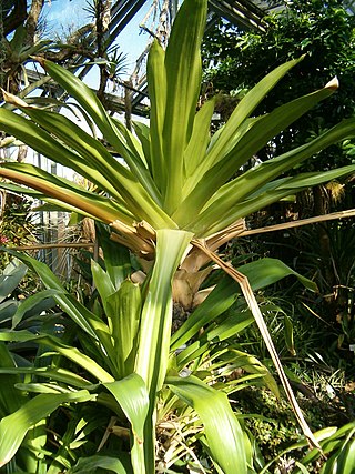
Brocchinia is a genus of the botanical family Bromeliaceae, and is the sole genus of the subfamily Brocchinioideae, containing 20 species. The genus is named for Giovanni Battista Brocchi, Italian naturalist (1772–1826). Brocchinia species are native primarily to the ancient Guayana Shield in southern Venezuela and Guyana, with some species extending into Colombia and northern Brazil. Its species are generally restricted to areas of sand and sandstone of the Roraima Formation; a few occur on granite.
Thoracocarpus is a genus of plants first described as a genus in 1958. It contains only one known species, Thoracocarpus bissectus a hemiepiphytic vine. It is native to Costa Rica, Panama, Cuba, Trinidad and Tobago, and South America.
Cerro Petaca is a large forested ridge in Amazonas state, Venezuela. It lies just west of the two high plateaus of Cerro Marahuaca and northeast of the massive Cerro Duida. The ridge reaches a height of at least 2,700 metres (8,900 ft) above sea level. Part of the Duida–Marahuaca Massif, it is entirely within the bounds of Duida–Marahuaca National Park.
Cerro Duida, known as Yennamadi by the Ye'kuana, is a very large tepui in Amazonas state, Venezuela. It has an uneven and heavily inclined plateau, rising from highs of around 1,300–1,400 metres (4,300–4,600 ft) in the north and east to a maximum of 2,358 metres (7,736 ft) on its southwestern rim. It has a summit area of 1,089 km2 (420 sq mi) and an estimated slope area of 715 km2 (276 sq mi). At its foot lies the small settlement of La Esmeralda, from which the mountain can be climbed.
Cerro Huachamacari, also spelled Huachamakari or Kushamakari, is a tepui in Amazonas state, Venezuela. It lies northwest of the giant Cerro Duida and the other peaks of the Duida–Marahuaca Massif, and is considerably lower at only around 1,900 metres (6,200 ft).
Araopán-tepui is a tepui in Bolívar state, Venezuela. It has an elevation of around 2,450 metres (8,040 ft) above sea level. Together with the larger Aprada-tepui to the west, it forms part of the Aprada Massif. A steep, semi-circular ridge connects these two summits.

Flora of the Venezuelan Guayana is a multivolume flora describing the vascular plants of the Guayana Region of Venezuela, encompassing the three states south of the Orinoco: Amazonas, Bolívar, and Delta Amacuro. Initiated by Julian Alfred Steyermark in the early 1980s, it was completed after his death under the guidance of Paul E. Berry, Kay Yatskievych, and Bruce K. Holst. The nine volumes were published between 1995 and 2005 by Timber Press and Missouri Botanical Garden Press. The project brought together more than 200 botanists from around the world and was "the first effort to produce a comprehensive inventory and identification guide for the plants of such an extensive region of northern South America".
Cerro La Luna is a small tepui in Bolívar state, Venezuela. It is situated off the northern flank of Auyán-tepui, just southeast of the similarly small Cerro El Sol, and forms part of the Auyán Massif. Both it and Cerro El Sol emerge near the end of a long forested ridge leading from Auyán-tepui. Cerro La Luna has an elevation of around 1,650 metres (5,410 ft) and a summit area of 0.2 km2 (0.077 sq mi).
Cerro El Sol, also known as Wei- or Uei-tepui, is a small tepui in Bolívar state, Venezuela. It is situated off the northern flank of Auyán-tepui, just northwest of the similarly small Cerro La Luna, and forms part of the Auyán Massif. Both it and Cerro La Luna emerge near the end of a long forested ridge leading from Auyán-tepui. Cerro El Sol has an elevation of around 1,750 metres (5,740 ft) and a summit area of 0.6 km2 (0.23 sq mi).
Kamarkawarai-tepui, also spelled Kamarkaiwaran or Camarcai-barai, is the easternmost and tallest of the four main tepuis of the Los Testigos chain in Bolívar, Venezuela. It is connected to the two nearest peaks of the massif—Murisipán-tepui and Tereke-yurén-tepui—by a common basement. The mostly bare summit plateau of Kamarkawarai-tepui has a large, collapsed sinkhole opening in its western portion.
Uaipán-tepui, also spelled Waipán, is a tepui in Bolívar state, Venezuela. It is a southern satellite peak of the vast Auyán Massif, with a maximum elevation of around 1,950 metres (6,400 ft). Its mostly forested summit plateau has an area of 2.5 km2 (0.97 sq mi). The mountain's slope area has been estimated at 60 km2 (23 sq mi).
Sororopán-tepui is a 10-kilometre (6.2 mi) long ridge in Bolívar state, Venezuela. It has a maximum elevation of around 2,050 m (6,730 ft) and its densely forested slopes cover an estimated area of 30 km2 (12 sq mi). The ridge has a southwest–northeast orientation and is characterised by a steep southern face. Part of the Ptari Massif, it lies just south of Carrao-tepui and neighbouring Ptari-tepui.
Carrao-tepui, also spelled Karrao, is a tepui in Bolívar state, Venezuela. It has a maximum elevation of around 2,200 metres (7,200 ft) and its densely forested summit plateau covers an area of 1.25 km2 (0.48 sq mi). Part of the Ptari Massif, it lies just northeast of neighbouring Ptari-tepui, with which it shares a common slope area of 28 km2 (11 sq mi), and north of the large ridge known as Sororopán-tepui.

Karaurín-tepui, also spelled Caraurín, is a tepui of the Eastern Tepuis chain in Bolívar state, Venezuela, just along the border with neighboring Guyana. It has a maximum elevation of around 2,500 metres (8,200 ft) above sea level. The summit plateau is covered by shrubby vegetation and has an area of 1.88 km2 (0.73 sq mi). The foothills of the tepui are covered in forests. Karaurín-tepui lies just south of the much larger Ilú–Tramen Massif.
Cerro Avispa is a tepui in Amazonas state, Venezuela. Part of the Neblina–Aracamuni Massif, it lies south of Cerro Aracamuni and north of Cerro de la Neblina. Cerro Avispa and Cerro Aracamuni have a combined summit area of 238 km2 (92 sq mi) and an estimated combined slope area of 658 km2 (254 sq mi). Both of these cerro-plateaus have a maximum elevation of around 1,600 metres (5,200 ft).

Fuchsia procumbens is a prostrate shrub that is endemic to coastal areas of the North Island of New Zealand. Common names include creeping fuchsia, climbing fuchsia or trailing fuchsia.
Soridium is a genus of myco-heterotrophic plants in the Triuridaceae, lacking chlorophyll and obtaining nutrients from fungi in the soil. It contains only one known species, Soridium spruceanum, native to Brazil, Venezuela, Suriname, French Guiana, Belize and Guatemala.
Excremis is a genus of herbs in the family Asphodelaceae, first described as a genus in 1829. There is only one known species, Excremis coarctata, native to South America.
Aratitiyopea is a monotypic genus of flowering plants, in the family Xyridaceae containing the single species Aratitiyopea lopezii. The genus was erected and described in 1984. This species is native to northern South America.
Diploon is a genus of plant in the family Sapotaceae described as a genus in 1946.