Pavant Range

Last updated
Pavant Range
USA Utah location map.svg
Red triangle with thick white border.svg
Pavant Range in Utah
Highest point
Peak Mine Camp Peak(Pavant Range
center, west
(Millard County))
Coordinates 38°52′27″N112°15′13″W / 38.87413°N 112.25355°W / 38.87413; -112.25355
Dimensions
Length 50 mi (80 km)SSW x NNE
Width 15 mi (24 km)E-W
Geography
Country United States
State Utah
Region Great Basin Desert, southeast
Counties Millard and Sevier
Cities Fillmore, UT, Richfield, UT &
Maple Grove, UT
Range coordinates 38°54′N112°13′W / 38.900°N 112.217°W / 38.900; -112.217 Coordinates: 38°54′N112°13′W / 38.900°N 112.217°W / 38.900; -112.217
Borders on Canyon Mountains-NNW
Sevier Desert-W & NW
Tushar Mountains-S
Valley Mountains-(minor range)-NE
Sevier Plateau-E & SE

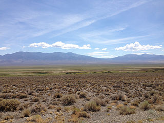
The Pavant Range (also Pahvant) is a mountain range in central Utah east of Fillmore. [1] The range is named for the Pahvant tribe, a branch of the Ute people. The tallest peak is Mine Camp Peak at 10,222 feet (3,116 m). [1] Most of the land in the Pavant range is part of Fishlake National Forest.

Utah A state of the United States of America

Utah is a state in the western United States. It became the 45th state admitted to the U.S. on January 4, 1896. Utah is the 13th-largest by area, 30th-most-populous, and 11th-least-densely populated of the 50 United States. Utah has a population of more than 3 million according to the Census estimate for July 1, 2016. Urban development is mostly concentrated in two areas: the Wasatch Front in the north-central part of the state, which contains approximately 2.5 million people; and Washington County in Southern Utah, with over 160,000 residents. Utah is bordered by Colorado to the east, Wyoming to the northeast, Idaho to the north, Arizona to the south, and Nevada to the west. It also touches a corner of New Mexico in the southeast.

Fillmore, Utah City in Utah, United States

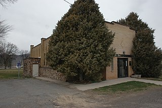
Fillmore is a city in Millard County, Utah, United States. The population was 2,253 at the 2000 United States Census. It is the county seat of Millard County. It is named for the thirteenth US President Millard Fillmore, who was in office when Millard County was created by the Utah Territorial legislature.

Pahvant

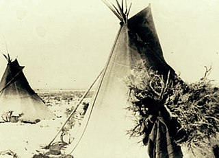
Pahvant was a band of Ute people that lived in present-day Utah. Called the "Water People", they fished and hunted waterfowl. They were also farmers and hunter-gatherers. In the 18th century they were known to be friendly and attentive, but after a chief's father was killed by emigrating white settlers, a group of Pahvant Utes killed John Williams Gunnison and seven of his men during his exploration of the area. The bodies of water of their homeland were dried up after Mormons had diverted the water for irrigation. Having intermarried with the Paiutes, they were absorbed into the Paiute Indian Tribe of Utah and relocated to reservations.

Contents

Richfield lies in the Sevier River valley to the southeast of the range and Fillmore lies in the Pavant Valley along the northwest side of the range. [2]

Richfield, Utah City in Utah, United States

Richfield is a city in and the county seat of Sevier County, Utah, in the United States, and is the largest city in southern-central Utah.

Sevier River river in central Utah, United States

The Sevier River is a 385-mile (620 km)-long river in the Great Basin of southwestern Utah in the United States. Originating west of Bryce Canyon National Park, the river flows north through a chain of high farming valleys and steep canyons along the west side of the Sevier Plateau, before turning southwest and terminating in the endorheic basin of Sevier Lake in the Sevier Desert. It is used extensively for irrigation along its course, with the consequence that Sevier Lake is usually dry.

The Pavant Range merges into the Tushar Mountains on the south.

Tushar Mountains

The Tushar Mountains are the third highest mountain range in Utah after the Uinta Mountains and the La Sal Range. Located in the Fishlake National Forest, Delano Peak, 12,174 ft  NAVD 88, is the highest point in both Beaver and Piute counties and has a prominence of 4,689 ft. Delano Peak is named for Columbus Delano (1809–1896), Secretary of the Interior during the Grant administration. The Tushars receive an ample amount of snow annually even though they are situated within the rainshadow of the Sierra Mountain Range located in California and the Snake Range located in Nevada.

Transportation

Interstate 15 crosses the extreme north end of the range at Scipio pass, near Scipio. [3] Interstate 70 crosses at a pass between the Pavant Range and the Tushar Mountains to the south. [2]

Interstate 15 (I-15) runs north–south in the U.S. state of Utah through the southwestern and central portions of the state, passing through many of the population centers of the state, including St. George, Provo, Salt Lake City, and Ogden, the latter three being part of the urban area known as the Wasatch Front. It is the primary north–south highway in Utah, as the majority of the state's population lives along its corridor. The only Metropolitan Statistical Area in Utah not connected by I-15 is the Logan Utah-Idaho Metropolitan Statistical Area. In 1998, the Utah Legislature designated the entire length within Utah as the Veterans Memorial Highway.

Scipio, Utah Town in Utah, United States

Scipio is a town on the eastern edge of Millard County, Utah, United States. The population was 290 at the 2000 census.

Interstate 70 (I-70) is a mainline route of the Interstate Highway System in the United States connecting Utah and Maryland. The Utah section runs east–west for approximately 232 miles (373 km) across the central part of the state. Richfield is the largest Utah city served by the freeway, which does not serve or connect any urban areas in the state. The freeway was built as part of a system of highways connecting Los Angeles and the northeastern United States. I-70 was the second attempt to connect southern California to the east coast of the United States via central Utah, the first being a failed attempt to construct a transcontinental railroad. Parts of that effort were re-used in the laying out of the route of I-70.

Meteorite

Iron meteorite fragments with a mass of 240 grams (8.5 oz) named the Salina meteorite were found in the Pavant Range in 1908. [4]

Iron meteorite meteorite composed of iron-nickel alloy called meteoric iron

Iron meteorites are meteorites that consist overwhelmingly of an iron–nickel alloy known as meteoric iron that usually consists of two mineral phases: kamacite and taenite. Iron meteorites originate from cores of planetesimals.

Related Research Articles

Funeral Mountains mountain range in California and Nevada, United States

The Funeral Mountains are a short, arid mountain range in the United States along the California-Nevada border approximately 100 mi (160 km) west of Las Vegas. The mountains are considered a subrange of the Amargosa Range that form the eastern wall of Death Valley.

Marysvale Canyon canyon in Piute and Sevier counties in Utah, United States

Marysvale Canyon is a canyon in Piute and Sevier counties in southwest Utah, United States which runs 8 miles (13 km) north from just north of Marysvale north to the town of Sevier.

Shoshone Mountains

The Shoshone Mountains, in west central Nevada, make up one of the longest mountain ranges in the state. The range runs in a general north-south direction in Nye and Lander counties. The range has a length of about 66 miles (106 km) and a width of about 6 mi (9.7 km) with an area of approximately 400 sq mi (1,000 km2).

Jacumba Mountains

The Jacumba Mountains are a mountain range of the Peninsular Ranges system, located in eastern San Diego County, Southern California, near the U.S. border with Mexico.

Vallecito Mountains

The Vallecito Mountains are located in the Colorado Desert, in eastern San Diego County, Southern California. They are about 28 miles (45 km) north of the U.S. border with Mexico.

Mescal Range

The Mescal Range is a small mountain range in the eastern Mojave Desert in California about 12 miles from the Nevada state line.

Meadow Valley Mountains

The Meadow Valley Mountains is a mountain range in Lincoln and Clark counties in southern Nevada. The range is a narrow north to northeast trending ridgeline with a length of about 40 miles (64 km). The Clover Mountains lie to the north, Meadow Valley Wash and the Mormon Mountains to the east, the Moapa Valley to the southeast, Arrow Canyon Range to the south, Coyote Springs Valley to the southwest and the Kane Springs Valley and Delamar Mountains to the west and northwest.

Fortification Range

The Fortification Range is a mountain range in Lincoln and White Pine counties, Nevada. The range is a narrow linear range trending north-northwest with a length of 34 km (21 mi) and a width of about 8 km (5.0 mi). It is typical of the Basin and Range Province.

Gap Mountains

The Gap Mountains are a mountain range in eastern Nye County, Nevada. Gap Mountain along with Fox Mountain 7.5 miles (12.1 km) to the south and the hills between overlook the White River valley to the west. Gap Mountain lies just 1.5 mi (2.4 km) southwest of the southern end of the Egan Range of adjacent Lincoln County and appears to be an extension of that range. Fox Mountain lies about 5 miles west of the south end of the Schell Creek Range and 7 mi (11 km) northeast of the north end of the Seaman Range.The Grant Range and small Golden Gate Range lie to the west across the White River Valley.

New Pass Range

The New Pass Range is a mountain range in Lander and Churchill counties of Nevada. The range is a north-south trending range which straddles the Lander-Churchill county boundary for about 16 miles (26 km). The highest peak New Pass Peak has an elevation of 9,003 feet (2,744 m). US Route 50 crosses New Pass Summit on the south end of the range between Austin to the east and Fallon on to the west. The range was named from an early settler's belief that his route through the mountains was a "new pass" through the area.

Reveille Range

The Reveille Range is the Nye County, Nevada mountain range that is the location of the Reveille Range volcanic field. The highest point is Reveille Peak in the southern part of the range with an elevation of 8,812 feet (2,686 m).

Tule Springs Hills

The Tule Springs Hills are a mountain range in eastern Lincoln County, Nevada. The Tule Desert lies to the west. The Mormon Mountains and East Mormon Mountains are to the southwest, the Clover Mountains to the north and the Beaver Dam Mountains of Utah are to the east.

Pahvant Butte

Pahvant Butte is a butte formed by a dormant volcano in the west-central portion of Utah, United States.

West Silver Bell Mountains

The West Silver Bell Mountains are a small 10 mile (16 km) long mountain range of south-central Arizona, United States. The range lies in the north-central arid Sonoran Desert; the Madrean Sky Islands region of southeast Arizona, around Tucson is adjacent to the southeast.

Sierra Madre Range (Wyoming)

The Sierra Madre Range is a mountain range in the western United States, located in south-central Wyoming and north-central Colorado. Geologically, it may be considered an extension of the Park Range of Colorado. South of the Great Divide Basin, the US Continental Divide runs along the Sierre Madre high points. Its western basins drain into the Colorado River and its eastern into the North Platte River. Buck Mountain is the highest peak in the range and lies within Colorado. Bridger Peak is its highest elevation on the Wyoming side of the range.

Shadow Valley is a north to northwest flowing drainage within the Mojave Desert of San Bernardino County, California. A section of Interstate 15 passes through the valley between Mountain Pass and Halloran Springs. The valley drains to the north from the west flank of the Mescal Range, the Ivanpah Mountains and Cima Dome within the Mojave National Preserve. North of I-15 the valley lies between Clark Mountains to the east and Shadow Mountain to the west. To the north of Shadow Mountain, Kingman Wash becomes the main drainage and turns to the west south of the Kingston Range. The Mesquite Mountains and the Mesquite Valley are to the northeast.

Canyon Mountains

The Canyon Mountains are a 25-mile (40 km) long mountain range located in the northeast corner of Millard County, Utah; the range is bisected north-south with a southeast border section of Juab County.

Mineral Mountains (Utah)

The Mineral Mountains are a 28 miles (45 km) long mountain range located in eastern Beaver and southeastern Millard counties in southwestern Utah. The Escalante Desert is to its southwest, the Black Rock Desert volcanic field and the Sevier Desert are to the north and northwest. The Pavant Range and Tushar Mountains lie to the east.

Valley Mountains

The Valley Mountains are a 28-mile (45 km) long mountain range located on the southwest border of Sanpete County, Utah, with the northeast border of Millard County. The north of the range is in Juab County; the south in Sevier County.

References

  1. 1 2 Utah Road and Recreation Atlas (Map). 1:250000. Benchmark Maps. 2002. p. 66. ISBN   0-929591-74-7.
  2. 1 2 Richfield, Utah, 30x60 Minute Topographic Quadrangle, USGS, 1980
  3. Delta, Utah, 30x60 Minute Topographic Quadrangle, USGS, 1989
  4. William F. Case. "Have meteorites or meteorite craters been found in Utah?". Utah Geological Survey - Utah Division of Natural Resources.