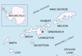
Hrabar Nunatak is a 160m rocky peak on the north coast of Greenwich Island in the South Shetland Islands, Antarctica, and overlooking Yakoruda Glacier to the south. The peak is "named after the Bulgarian scholar Chernorizets Hrabar .".

Nikopol Point is a snow-free point on the south coast of Byers Peninsula, Livingston Island in the South Shetland Islands, Antarctica projecting 650 m east-southeastwards into Bransfield Strait and linked by a spit to Vietor Rock to the south. The area was visited by early 19th century sealers who had dwellings at the foothills of nearby Sealer Hill.

Rila Point is a low, ice-free point on the south coast of Moon Bay, projecting 330 m west-northwestwards from Burgas Peninsula on Livingston Island in the South Shetland Islands, Antarctica, and forming the east side of the entrance to Bruix Cove. The point is named after Rila Mountain, Bulgaria.

Zheravna Glacier is a glacier on Greenwich Island, Antarctica situated east of Wulfila Glacier and west of Targovishte Glacier. It is bounded by Razgrad Peak to the west, Ilinden Peak and Momchil Peak to the north, and Viskyar Ridge to the east, extending 2 km in the east-west direction and 1.8 km in the north-south direction, and draining southwards into McFarlane Strait between Ephraim Bluff and Sartorius Point.

Aytos Point is a point on the coast of Bransfield Strait, Livingston Island, Antarctica formed by an offshoot of Christoff Cliff. The point was named after the Bulgarian town of Aytos.

Yovkov Point is a point on the southwest coast of Greenwich Island, Antarctica projecting 150 m southwards into McFarlane Strait, forming the northwest side of the entrance to Kramolin Cove. Formed as a result of Murgash Glacier's retreat in the late 20th and early 21st century. The feature is named after the famous Bulgarian writer Yordan Yovkov (1880–1937).

Kaspichan Point is a point on the southeast side of the entrance to Kramolin Cove on the southwest coast of Greenwich Island, Antarctica. Situated next west of Hebrizelm Hill, 1.4 km northwest of Triangle Point, 2 km south-southwest of Tile Ridge, and 2 km southeast of Yovkov Point. Shape enhanced by recent glacier retreat northwest of the point. Bulgarian topographic survey Tangra 2004/05. Named after the town of Kaspichan in northeastern Bulgaria.

Beron Point is a point on the southwest coast of Robert Island, Antarctica situated 4.5 km southeast of Negra Point, 1.7 km west of Bajo Nunatak, 1.8 km west-northwest of Zahari Point, and 3.7 km northwest of Edwards Point, as well as 5 km northeast of Ash Point on Greenwich Island. Its shape has been enhanced by a recent glacier retreat north-northwest of the point. It was named after the prominent Bulgarian scientist and educator Dr. Petar Beron (1795–1871).

Elemag Point is a point on the coast of Moon Bay in Livingston Island, Antarctica situated 6.75 km south-southwest of Edinburgh Hill, 1.76 km southeast of Sindel Point, 3.05 km east of Sliven Peak, 2.05 km northeast of Zlatograd Rock, and 5,57 km northwest of Rila Point. Separates the glacier termini of Struma Glacier to the north and Huron Glacier to the south. Bulgarian topographic survey Tangra 2004/05.

Garmen Point is a point on the northwest coast of Smith Island, South Shetland Islands situated 13.65 km north-northeast of Cape James, 6.12 km south-southwest of Markeli Point and 19.65 km southwest of Cape Smith. Formed by an offshoot of Mount Foster. Bulgarian early mapping in 2008. Named after the settlement of Garmen in southwestern Bulgaria.

Miletich Point is the rocky point forming the west side of the entrance to Haskovo Cove on Greenwich Island, South Shetland Islands in Antarctica. Stuated 800 m north of the summit of Crutch Peaks, 200 m southeast of Kabile Island, 1.55 km east of Pavlikeni Point, and 2.1 km west of Aprilov Point.

Divotino Point is a sharp, low ice-free point on the southeast coast of Alfatar Peninsula on Robert Island in the South Shetland Islands, Antarctica projecting 200 m into Mitchell Cove. Situated 2 km northeast of Debelyanov Point and 3.35 km north by west of Negra Point.

Voluyak Rocks is a chain of rocks off the north coast of Greenwich Island in the South Shetland Islands, Antarctica situated 400 m (440 yd) north of Pavlikeni Point. Extending 1.9 km (1.2 mi) in southeast-northwest direction.

Pelishat Point is the point forming the south extremity of Archar Peninsula and the north side of the entrance to Berende Cove on the southwest coast of Greenwich Island in the South Shetland Islands, Antarctica. It is situated 2.4 km southeast of Duff Point and 3.9 km northeast of Pomorie Point on Livingston Island.

Ongley Island is a rugged rocky island lying off the north coast of Greenwich Island in the South Shetland Islands, Antarctica. Extending 1.35 km (0.84 mi) in west-northwest direction and 470 m (510 yd) wide, with a surface area of 44 hectares. The area was visited by early 19th century sealers.

Yasen Point is the sharp, rocky point on the south coast of Livingston Island in the South Shetland Islands, Antarctica, forming the west side of the entrance to Mateev Cove. Situated on the east side of the small ice-free promontory ending in Hannah Point to the west.

Brusen Point is the narrow rocky point projecting 200 m in north-northwest direction and forming the north extremity of Greenwich Island in the South Shetland Islands, Antarctica.

Dragash Point is the rocky point forming the south extremity of Dee Island in the South Shetland Islands, Antarctica.

Varbak Point is the ice-covered point on the southwest side of the entrance to Pakusha Cove on the southeast coast of Smith Island in the South Shetland Islands, Antarctica. The point is named after the settlement of Varbak in Northeastern Bulgaria.


