
The Konkan Railway is one of the 19 railway zones in India with its headquarters at CBD Belapur in Navi Mumbai, Maharashtra, India. The first passenger train ran on Konkan railway tracks on 20 March 1993, between Udupi and Mangalore. During its initial years of operation in the mountainous Konkan region, a number of accidents prompted Konkan Railway to implement new technology. Anti-collision devices, the Sky Bus and roll-on/roll-off are several of the railway's innovations. The 756.25 km (469.91 mi) long railway line connects the states of Maharashtra, Goa and Karnataka. The first train on the completed track was sent off on 26 January 1998.
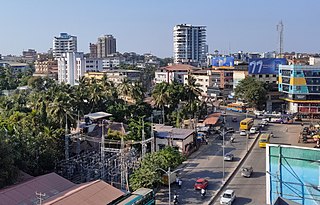
Mangalore, officially known as Mangaluru, is a major port city in the Indian state of Karnataka & on the west coast of India. It is located between the Arabian Sea and the Western Ghats about 352 km (219 mi) west of Bangalore, the state capital, 20 km north of Karnataka–Kerala border, 297 km south of Goa. Mangalore is the state's only city to have all four modes of transport—air, road, rail and sea. The population of the urban agglomeration was 619,664 according to the 2011 national census of India. It is known for being one of the locations of the Indian strategic petroleum reserves.

Dakshina Kannada district is a district of Karnataka state in India, with its headquarters in the coastal city of Mangalore. It is part of the larger Tulu Nadu & bearys region. The district covers an area nestled in between the Western Ghats to its east and the Arabian Sea to its west. Dakshina Kannada receives abundant rainfall during the Indian monsoon. It is bordered by Udupi district to the north, Chikmagalur district to the northeast, Hassan district to the east, Kodagu to the southeast and Kasaragod district of Kerala to the south. According to the 2011 census of India, Dakshina Kannada district had a population of 2,083,625. It is the only district in Karnataka state to have all modes of transport like road, rail, water and air due to the presence of a major hub, Mangalore. This financial district is also known as the Cradle of Indian banking.

Manipal is a suburb and university town within Udupi, in coastal Karnataka, India. Manipal is located five kilometres away from the centre of Udupi City, in Udupi District, Karnataka (state) in south western India. It is administered by the Udupi City Municipality. The suburb is located in coastal Karnataka, 62 km north of Mangalore and 8 km east of the Arabian Sea. From its location on a plateau, at an altitude of about 75 m above sea level, it commands a panoramic view of the Arabian Sea to the west and the Western Ghats to the east.

Karwar is a seaside city, taluka, and administrative headquarters of Uttara Kannada district lying at the mouth of the Kali river on the Kanara coast of Karnataka state, India.

The Netravati River or Netravathi Nadi has its origins at Bangrabalige valley, Yelaneeru Ghat in Kudremukh in Chikkamagaluru district of Karnataka, India. This river flows through the famous pilgrimage place Dharmasthala and is considered one of the holy rivers of India. It merges with the Kumaradhara River at Uppinangadi before flowing to the Arabian Sea, south of Mangalore city. This river is the main source of water to Bantwal and Mangalore. The Netravati railway bridge is one of the known bridges which serve as the gateway to Mangalore.

Pamban Bridge is a railway bridge that connects the town of Mandapam in mainland India with Rameswaram on Pamban Island. Opened on 24 February 1914, it was India's first sea bridge, and was the longest sea bridge in India until the opening of the Bandra-Worli Sea Link in 2010. The rail bridge is, for the most part, a conventional bridge resting on concrete piers but has a double-leaf bascule section midway, which can be raised to let ships and barges pass through. Until 1988, the Pamban bridge was the only surface transport that connected Tamil Nadu's island of Rameswaram to the mainland India. On 23 December 2022, the bascule of this bridge was damaged due to extreme corrosion and so the sensors gave continuous warning signal which suspended transportation on the bridge for permanently. The last train which was officially ran on this bridge was Train no. 07695 Secunderabad Rameswaram Special which completed its commercial journey on the day end of 22 December 2022.
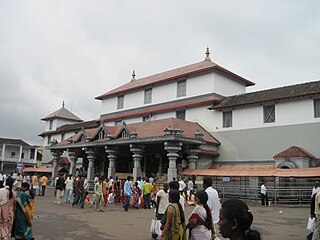
Dharmasthala(listen ) is an Indian temple town on the banks of the Nethravathi River in the Belthangady taluk of the Dakshina Kannada district in Karnataka, India.

Ranganathittu Bird Sanctuary, is a bird sanctuary in the Mandya District of the state of Karnataka in India. It is the largest bird sanctuary in the state, 40 acres (16 ha) in area, and comprises six islets on the banks of the Kaveri river. The sanctuary has been designated as a protected Ramsar site since 2022.

Udupi district is an administrative subdivision in the Karnataka state of India, with the district headquarters in the city of Udupi. It is situated in the Canara old north malabar coastal region, there are seven taluks, 233 villages and 21 towns in Udupi district. The three northern tehsils of Udupi, Kundapur and Karkala, were partitioned from Dakshina Kannada district to form Udupi district on 25 August 1997. Moodabidri was officially declared as new tehsil (taluk), separated from Karkala with effect from 11 January 2018.

Netrani is a small island of India located in the Arabian Sea. It is mostly famous for Jai Bajrangbali Temple, an ancient Hindu Temple. It is off the coast of Karnataka situated approximately 10 nautical miles (19 km) from the temple town of Murudeshwara in Bhatkal Taluka. The island can be seen from the mainland over 15 km away. Views above give this island the appearance of being heart-shaped. Its animal inhabitants include wild goats and pigeons. It has scuba diving facilities and is easily accessible from Bhatkal, Mangalore, Goa, Mumbai or Bangalore. There are dive shops at Murdeshwara and Goa which regularly organize trips to the island. It is known locally as Nitra Gudo. The famous Hindu temple Jai Bajrangbali Temple is located here.

Kottiyoor is a village and Grama Panchayat situated in eastern hilly area of Kannur district in Kerala state. Kottiyoor is the 23rd Wildlife Sanctuary of Kerala, located in the serene hills of Western Ghats. The ancient pilgrimage conducted here yearly, called 'Kottiyoor Vysakha Mahotsavam' attracts thousands of devotees every year. The Vavali river flows through Kottiyoor.
Mangalore Electricity Supply Company Limited is an Indian electricity supplier to the districts of Karnataka namely Dakshina Kannada, Udupi district, Chickmagalur and Shimoga. It has its headquarters at Mangaluru. The company was formed on June 2002.

Cherupuzha is a town in Kannur district, Kerala, India. It is the headquarters of the Cherupuzha Panchayat which is a special grade panchayat in Kerala.
Tonse is a combined village, which include Tonse West and Tonse East situated about 8 kilometres (5.0 mi) from Udupi on the western coast of South India, between the Arabian Sea and Western Ghats. Tonse village is about 68 kilometres (42 mi) to the north of Mangalore.
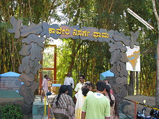
Kaveri Nisargadhama is a delta which is called as island by local people, formed by river Kaveri near Kushalnagar in the district of Kodagu, Karnataka, India.

The 2008 attacks on Christians in southern Karnataka refer to the wave of attacks directed against Christian churches and prayer halls in the Indian city of Mangalore and the surrounding area of southern Karnataka in September and October 2008 by Hindu nationalist organisations, Bajrang Dal and the Sri Ram Sena. The attacks were widely perceived by Christians in southern Karnataka to be punishment from right-wing Hindu nationalist organisations because they had been outspoken about 2008 anti-Christian attacks in Orissa, and also because the New Life Fellowship Trust (NLFT), a non-denominational Christian Church, was alleged by Bajrang Dal to be responsible for forced conversions of Hindus to Christianity.

Mangaluru Central railway station, formerly Mangalore Central railway station is the main railway terminus in the city of Mangalore. It is one of the major railway stations in Karnataka state and it is the biggest terminal station under Palakkad railway division. There is also another railway station named Mangalore Junction railway station, previously known as Kankanady railway station. The Mangalore region provides the highest freight revenue to the Palakkad division, which sums up to 90 percent of the total revenue which the Palakkad division generates. Mangalore Central comes under the Southern Railway and also provides connectivity for Konkan Railway and South Western Railway of the Indian Railways. It is one of the 5 central railway stations of India.
National Highway 66, commonly referred to as NH 66, is a mostly 4 lane 1,608 km (999 mi) long busy National Highway that runs roughly north–south along the western coast of India, parallel to the Western Ghats. It connects Panvel to Cape Comorin (Kanyakumari), passing through the states of Maharashtra, Goa, Karnataka, Kerala and Tamil Nadu.

The city of Mangalore is proclaimed as the gateway to Karnataka and lies nestled between the blue waters of the Arabian Sea and the green, towering hills of the Western Ghats. The 184 square km city is spread out over the backwaters of the two rivers, Netravati and Gurpura.


