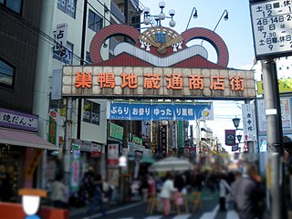
Sugamo (巣鴨) is a neighborhood in Toshima, Tokyo, Japan. Jizō-dōri (地蔵通り), a shopping street for the older generation is located here. It lies at the crossing point of the JR Yamanote Line, and National Route 17.
Horbów-Kolonia is a village in the administrative district of Gmina Zalesie, within Biała Podlaska County, Lublin Voivodeship, in eastern Poland.

Arduşlu is a village in the Lachin Rayon of Azerbaijan.
Qaraçanlı is a village in the Lachin Rayon of Azerbaijan.

Rzeczyca(listen) is a village in the administrative district of Gmina Zadzim, within Poddębice County, Łódź Voivodeship, in central Poland. It lies approximately 5 kilometres (3 mi) south of Zadzim, 20 km (12 mi) south-west of Poddębice, and 44 km (27 mi) west of the regional capital Łódź.
Kolosy is a village in the administrative district of Gmina Czarnocin, within Kazimierza County, Świętokrzyskie Voivodeship, in south-central Poland. It lies approximately 8 kilometres (5 mi) south-east of Czarnocin, 11 km (7 mi) north-east of Kazimierza Wielka, and 63 km (39 mi) south of the regional capital Kielce.
Stare Kichary is a village in the administrative district of Gmina Dwikozy, within Sandomierz County, Świętokrzyskie Voivodeship, in south-central Poland. It lies approximately 5 kilometres (3 mi) north-west of Dwikozy, 9 km (6 mi) north of Sandomierz, and 81 km (50 mi) east of the regional capital Kielce.
Rządza is a village in the administrative district of Gmina Stanisławów, within Mińsk County, Masovian Voivodeship, in east-central Poland.
Kiełki is a village in the administrative district of Gmina Baboszewo, within Płońsk County, Masovian Voivodeship, in east-central Poland.
Antonin is a village in the administrative district of Gmina Kostrzyn, within Poznań County, Greater Poland Voivodeship, in west-central Poland.
Lutyniec is a settlement in the administrative district of Gmina Wronki, within Szamotuły County, Greater Poland Voivodeship, in west-central Poland.
Obelzanki is a village in the administrative district of Gmina Wronki, within Szamotuły County, Greater Poland Voivodeship, in west-central Poland. It lies approximately 5 kilometres (3 mi) north of Wronki, 20 km (12 mi) north-west of Szamotuły, and 52 km (32 mi) north-west of the regional capital Poznań.
Turzonka is a settlement in the administrative district of Gmina Dziemiany, within Kościerzyna County, Pomeranian Voivodeship, in northern Poland. It lies approximately 5 kilometres (3 mi) north-west of Dziemiany, 19 km (12 mi) south-west of Kościerzyna, and 69 km (43 mi) south-west of the regional capital Gdańsk.
Nowe Witki is a settlement in the administrative district of Gmina Bartoszyce, within Bartoszyce County, Warmian-Masurian Voivodeship, in northern Poland, close to the border with the Kaliningrad Oblast of Russia. It lies approximately 9 kilometres (6 mi) north of Bartoszyce and 64 km (40 mi) north of the regional capital Olsztyn.
Łysogóra is a village in the administrative district of Gmina Dubeninki, within Gołdap County, Warmian-Masurian Voivodeship, in northern Poland, close to the border with the Kaliningrad Oblast of Russia. It lies approximately 13 kilometres (8 mi) north-east of Dubeninki, 28 km (17 mi) east of Gołdap, and 159 km (99 mi) north-east of the regional capital Olsztyn.
Lubień Górny is a settlement in the administrative district of Gmina Resko, within Łobez County, West Pomeranian Voivodeship, in north-western Poland. It lies approximately 8 kilometres (5 mi) south-east of Resko, 16 km (10 mi) north-west of Łobez, and 68 km (42 mi) north-east of the regional capital Szczecin.
Přestavlky u Čerčan is a municipality and village in Benešov District in the Central Bohemian Region of the Czech Republic.
Malý Újezd is a village and municipality in Mělník District in the Central Bohemian Region of the Czech Republic.

Bumburet is the largest valley of Kalasha Desh in Chitral District, Khyber Pakhtunkhwa, Pakistan.

Haynes is a hamlet in central Alberta, Canada within Lacombe County. It is located 3 kilometres (1.9 mi) north of Highway 11, approximately 28 kilometres (17 mi) east of Red Deer.


