O Valadouro is a municipality in the Galician province of Lugo. O Valadouro belongs to the region of A Mariña Central. Its capital is the town of Ferreira. In 2011, it had 2,180 inhabitants according to the INE.

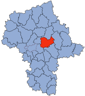
Czerwińsk nad Wisłą is a village in Płońsk County, Masovian Voivodeship, in east-central Poland. It is the seat of the gmina called Gmina Czerwińsk nad Wisłą. It lies on the Vistula (Wisła) river, approximately 29 kilometres (18 mi) south of Płońsk and 52 km (32 mi) west of Warsaw. The village has a population of 1,200.

Lúčka is a village and municipality in Svidník District in the Prešov Region of north-eastern Slovakia.

Trzy Chałupy is a village in the administrative district of Gmina Twardogóra, within Oleśnica County, Lower Silesian Voivodeship, in south-western Poland. Prior to 1945 it was in Germany.
Płusy is a village in the administrative district of Gmina Księżpol, within Biłgoraj County, Lublin Voivodeship, in eastern Poland. It lies approximately 4 kilometres (2 mi) south of Księżpol, 18 km (11 mi) south of Biłgoraj, and 96 km (60 mi) south of the regional capital Lublin.
Radunin is a village in the administrative district of Gmina Gródek, within Białystok County, Podlaskie Voivodeship, in north-eastern Poland, close to the border with Belarus.
Wierch-Topolany is a village in the administrative district of Gmina Michałowo, within Białystok County, Podlaskie Voivodeship, in north-eastern Poland, close to the border with Belarus.
Gorędy is a village in the administrative district of Gmina Narew, within Hajnówka County, Podlaskie Voivodeship, in north-eastern Poland.
Katarzynów is a village in the administrative district of Gmina Ozorków, within Zgierz County, Łódź Voivodeship, in central Poland. It lies approximately 8 kilometres (5 mi) east of Ozorków, 12 km (7 mi) north of Zgierz, and 20 km (12 mi) north of the regional capital Łódź.
Obłazy Ryterskie is a village in the administrative district of Gmina Rytro, within Nowy Sącz County, Lesser Poland Voivodeship, in southern Poland. It lies approximately 2 kilometres (1 mi) south of Rytro, 17 km (11 mi) south of Nowy Sącz, and 84 km (52 mi) south-east of the regional capital Kraków.
Zalesie is a village in the administrative district of Gmina Nowe Miasto nad Pilicą, within Grójec County, Masovian Voivodeship, in east-central Poland. It lies approximately 14 kilometres (9 mi) west of Nowe Miasto nad Pilicą, 40 km (25 mi) south-west of Grójec, and 75 km (47 mi) south-west of Warsaw.
Dobrzyków is a village in the administrative district of Gmina Gąbin, within Płock County, Masovian Voivodeship, in east-central Poland. It lies approximately 9 kilometres (6 mi) north of Gąbin, 9 km (6 mi) south of Płock, and 90 km (56 mi) west of Warsaw.
Rostki is a village in the administrative district of Gmina Miedzna, within Węgrów County, Masovian Voivodeship, in aest-central Poland.
Sierpówko is a village in the administrative district of Gmina Kaźmierz, within Szamotuły County, Greater Poland Voivodeship, in west-central Poland.
Tokarów is a settlement in the administrative district of Gmina Nowe Miasto nad Wartą, within Środa Wielkopolska County, Greater Poland Voivodeship, in west-central Poland. It lies approximately 24 kilometres (15 mi) south of Środa Wielkopolska and 53 km (33 mi) south-east of the regional capital Poznań.
Kaliszkowice is a settlement in the administrative district of Gmina Skąpe, within Świebodzin County, Lubusz Voivodeship, in western Poland. It lies approximately 3 kilometres (2 mi) south-east of Skąpe, 14 km (9 mi) south of Świebodzin, and 22 km (14 mi) north of Zielona Góra.
Winda is a village in the administrative district of Gmina Barciany, within Kętrzyn County, Warmian-Masurian Voivodeship, in northern Poland, close to the border with the Kaliningrad Oblast of Russia. It lies approximately 8 kilometres (5 mi) south-east of Barciany, 9 km (6 mi) north of Kętrzyn, and 72 km (45 mi) north-east of the regional capital Olsztyn.
Olszewo is a village in the administrative district of Gmina Olecko, within Olecko County, Warmian-Masurian Voivodeship, in northern Poland. It lies approximately 9 kilometres (6 mi) north-west of Olecko and 129 km (80 mi) east of the regional capital Olsztyn.
Přepeře is a village and municipality in Mladá Boleslav District in the Central Bohemian Region of the Czech Republic.
Chepigovo is a village in Municipality of Prilep, Republic of Macedonia.