Novaci is a village in Republic of Macedonia. It is a seat of the Novaci municipality. The inhabitants are mainly farmers and livestock breeders, and some of them are employed in the local plants: REK Bitola, ZK Pelagonija and Macedonian Woods.

Szonowo Królewskie is a village in the administrative district of Gmina Łasin, within Grudziądz County, Kuyavian-Pomeranian Voivodeship, in north-central Poland. It lies approximately 4 kilometres (2 mi) east of Łasin, 25 km (16 mi) east of Grudziądz, and 63 km (39 mi) north-east of Toruń.

Fərzalı is a village in the Gadabay Rayon of Azerbaijan. The village forms part of the municipality of Arabaçı.
Kletnia-Kolonia is a village in the administrative district of Gmina Gomunice, within Radomsko County, Łódź Voivodeship, in central Poland. It lies approximately 10 kilometres (6 mi) north-east of Radomsko and 71 km (44 mi) south of the regional capital Łódź.
Parama is a village in the administrative district of Gmina Tomaszów Lubelski, within Tomaszów Lubelski County, Lublin Voivodeship, in eastern Poland.
Papiernia is a village in the administrative district of Gmina Stanisławów, within Mińsk County, Masovian Voivodeship, in east-central Poland.
Żukowo-Poświętne is a village in the administrative district of Gmina Naruszewo, within Płońsk County, Masovian Voivodeship, in east-central Poland.
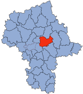
Baraki is a village in the administrative district of Gmina Sochocin, within Płońsk County, Masovian Voivodeship, in east-central Poland.
Słowików is a village in the administrative district of Gmina Przytyk, within Radom County, Masovian Voivodeship, in east-central Poland.
Starawieś is a village in the administrative district of Gmina Liw, within Węgrów County, Masovian Voivodeship, in east-central Poland. It lies approximately 8 kilometres (5 mi) north-west of Węgrów and 70 km (43 mi) east of Warsaw.
Chrząszczewo is a village in the administrative district of Gmina Wierzbinek, within Konin County, Greater Poland Voivodeship, in west-central Poland.
Prętkowice is a village in the administrative district of Gmina Śmigiel, within Kościan County, Greater Poland Voivodeship, in west-central Poland.
Kidów is a village in the administrative district of Gmina Pilica, within Zawiercie County, Silesian Voivodeship, in southern Poland. It lies approximately 6 kilometres (4 mi) north-east of Pilica, 21 km (13 mi) east of Zawiercie, and 58 km (36 mi) north-east of the regional capital Katowice.
Laska is a village in the administrative district of Gmina Nowa Wieś Lęborska, within Lębork County, Pomeranian Voivodeship, in northern Poland. It lies approximately 12 kilometres (7 mi) south-west of Nowa Wieś Lęborska, 13 km (8 mi) south-west of Lębork, and 71 km (44 mi) west of the regional capital Gdańsk.

Pobłocie is a village in the administrative district of Gmina Główczyce, within Słupsk County, Pomeranian Voivodeship, in northern Poland. It lies approximately 9 kilometres (6 mi) east of Główczyce, 36 km (22 mi) north-east of Słupsk, and 79 km (49 mi) west of the regional capital Gdańsk.
Kranek Drugi is a settlement in the administrative district of Gmina Skórcz, within Starogard County, Pomeranian Voivodeship, in northern Poland.
Karwica is a village in the administrative district of Gmina Ruciane-Nida, within Pisz County, Warmian-Masurian Voivodeship, in northern Poland. It lies approximately 10 kilometres (6 mi) south of Ruciane-Nida, 21 km (13 mi) west of Pisz, and 71 km (44 mi) east of the regional capital Olsztyn.
Śwignajno is a village in the administrative district of Gmina Ruciane-Nida, within Pisz County, Warmian-Masurian Voivodeship, in northern Poland. It lies approximately 10 kilometres (6 mi) south of Ruciane-Nida, 21 km (13 mi) west of Pisz, and 71 km (44 mi) east of the regional capital Olsztyn.
Mszanka is a settlement in the administrative district of Gmina Postomino, within Sławno County, West Pomeranian Voivodeship, in north-western Poland. It lies approximately 5 kilometres (3 mi) south of Postomino, 11 km (7 mi) north of Sławno, and 181 km (112 mi) north-east of the regional capital Szczecin.

Mirjaveh County is a county in Sistan and Baluchestan Province in Iran. The capital of the county is Mirjaveh. It was separated from Zahedan County in 2013. At the 2006 census, the county's population was 45,896, in 8,481 families. The county has one district (bakhsh): the Central District. The county has one city: Mirjaveh.