
Paya Lebar Office Centre, formerly the Geylang Fire Station and the Paya Lebar Fire Station, is a commercial and industrial office complex and a former fire station in Singapore.
Paya Lebar Office Centre, formerly the Geylang Fire Station and the Paya Lebar Fire Station, is a commercial and industrial office complex and a former fire station in Singapore.
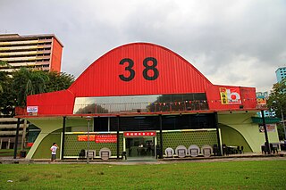
The building features a cantilevered balcony, vertical balustrades on the second floor. It has tall ceilings, as well as floor-to-ceiling doors and window shutters that were painted red. As with many other Colonial-era buildings in Singapore, the eaves of the building's hip roof are extended. [1]
The fire station was opened at the corner of Sims Avenue and Paya Lebar Road in 1929, serving the Eastern part of Singapore. This makes it the second oldest existing fire station in Singapore. It was later renamed the Paya Lebar Fire Station. [2] In 1951, a prayer room was installed in the station, allowing on-duty Muslim firefighters to be able to perform prayers while at the station. [1] It ceased operations in 2002. [3] The fire station was replaced by the Paya Lebar Fire Station on Ubi Avenue. [1]
The building was gazetted for conservation by the Urban Redevelopment Authority in April 2007. [4] In September 2012, Irfan Kasban's play This Placement was staged at the fire station. [5] In April 2015, the National Heritage Board placed the building on the Geylang Serai Foot Trail, a heritage trail covering the Geylang Serai neighbourhood. [6]

The Paya Lebar Air Base is a military airbase of the Republic of Singapore Air Force (RSAF) in Singapore located at Airport Road in Paya Lebar, in the eastern region of Singapore. The airbase goes by the motto of Strength Through Readiness.

Geylang is a planning area and township located on the eastern fringe of the Central Region of Singapore, bordering Hougang and Toa Payoh in the north, Marine Parade in the south, Bedok in the east, and Kallang in the west.

Kallang is a planning area and residential zone located in the Central Region of Singapore.

Paya Lebar is a planning area located in the East Region of Singapore, bordered by Hougang to the west, Sengkang to the northwest, Tampines to the east, Bedok to the south and Pasir Ris to the north.

Serangoon is a planning area and residential town located in the North-East Region of Singapore.

MacPherson is a neighbourhood located within the district of Geylang in the Central Region of Singapore. Its location roughly corresponds to the identically titled subzone in the Geylang Planning Area and is approximately sandwiched between the neighbourhoods of Aljunied and Paya Lebar. MacPherson largely consists of various public housing estates centered on Circuit Road and an industrial area. The Pelton Canal runs through the neighbourhood, which separates a private housing estate off MacPherson Road, and the public housing estate along Circuit Road.

Paya Lebar MRT station is a Mass Rapid Transit (MRT) interchange station on the East West line (EWL) and Circle line (CCL) in Geylang, Singapore. Despite the name, this station is not located in Paya Lebar but rather along Paya Lebar Road, near the junction with Sims Avenue. It is located among the developments of the Paya Lebar Central commercial hub and near the Geylang Serai district.

Bedok is a planning area and residential town located in the geographical region of Tanah Merah along the south-eastern coast of the East Region of Singapore. Bedok is bounded by five other planning areas: Paya Lebar to the north, Hougang to the northwest, Tampines to the northeast and east, Geylang to the west and Marine Parade to the southwest. It also shares a maritime boundary with the Singapore Strait to the south and southeast.

Eunos MRT station is an above-ground Mass Rapid Transit (MRT) station on the East West MRT Line in Geylang, Singapore. It is located next to the Eunos Bus Interchange.
The Malay Village, predecessor of present day Wisma Geylang Serai, was a museum once located in Geylang, Singapore, where they showcases the life of the Malays who used to live in the area before redevelopment in the 1960s.

Kallang Airport was the first purpose-built civil international airport in Singapore, opened officially on 12 June 1937 and ceased operations in 1955, when it was relocated to Paya Lebar. Situated on the eastern shore of the Kallang Basin, the Kallang Airport spanned the modern planning areas of Kallang and Geylang at its greatest extent. The conserved complex, including the airport's terminal building, is located wholly within Kallang.

This article shows the notable future developments in Singapore. Most of them are currently under construction with most to be completed within the next five years.

The North-East Region of Singapore is one of the five regions in the country. The region is the most densely populated and has the highest population among the five, with Sengkang being its most populous town as of 2020 and Seletar as the regional centre. Comprising 13,810 hectares, it includes seven planning areas and is largely a residential region with 217,120 homes. Housing largely consists of high-density HDB public housing estates, however private housing is also present in the region. As its name implies, it is located in the north-eastern part of Singapore.

Kovan is a neighbourhood located within the town of Hougang, in Singapore. The neighbourhood today largely consists of private housing properties, where majority of the residents live in terrace homes, semi-detached houses and bungalows.

Boon Keng is a subzone within the planning area of Kallang, Singapore, as defined by the Urban Redevelopment Authority (URA). The smallest in terms of physical area among the nine subzones that make up Kallang, Boon Keng is bounded by the Pelton Canal in the north; the Kallang–Paya Lebar Expressway (KPE) and Sims Way in the east; Sims Avenue in the south; and the Kallang River in the west.

Kampong Bugis is a subzone within the planning area of Kallang, Singapore, as defined by the Urban Redevelopment Authority (URA). This subzone is bounded by Kallang Road and Sims Avenue in the north; the Kallang–Paya Lebar Expressway (KPE) and Sims Way in the east; Nicoll Highway in the south; and Crawford Street in the west.
Road names in Singapore come under the purview of the Street and Building Names Board of the Urban Redevelopment Authority. In 1967, the Advisory Committee on the Naming of Roads and Streets was formed to name roads in Singapore. The committee was eventually renamed the Street and Building Names Board (SBNB) in 2003. The secretariat role of SBNB was taken over by Urban Redevelopment Authority in 2010 and SBNB is under the Ministry of National Development of Singapore.

Tanjong Katong Complex is a shopping complex in Geylang Serai, Singapore. Completed in 1982, the complex was the first air-conditioned shopping complex built by the Housing and Development Board and has since become known for servicing the Malay community in the area.
Commonwealth Avenue Wet Market, also known as Queenstown Market, is a former wet market on Commonwealth Avenue in Queenstown, Singapore. It is the only remaining market designed by the Singapore Improvement Trust.

The Chek Jawa Visitor Centre, also known as House No. 1, is a visitor centre and former holiday home on Pulau Ubin, Singapore. It is believed to be the last remaining authentic Tudor-style building in the country.