Related Research Articles

The Liard River of the North American boreal forest flows through Yukon, British Columbia and the Northwest Territories, Canada. Rising in the Saint Cyr Range of the Pelly Mountains in southeastern Yukon, it flows 1,115 km (693 mi) southeast through British Columbia, marking the northern end of the Rocky Mountains and then curving northeast back into Yukon and Northwest Territories, draining into the Mackenzie River at Fort Simpson, Northwest Territories. The river drains approximately 277,100 km2 (107,000 sq mi) of boreal forest and muskeg.
Fort Nelson is a community in northeast British Columbia, Canada, within the Northern Rockies Regional Municipality (NRRM). It held town status prior to 6 February 2009, when it amalgamated with the former Northern Rockies Regional District to form the NRRM, becoming its administrative centre. The NRRM is the first regional municipality in the province.

Prince George—Peace River—Northern Rockies is a federal electoral district in northern British Columbia, Canada. It has been represented in the House of Commons of Canada since 1968.
Peace River North is a provincial electoral district for the Legislative Assembly of British Columbia, Canada. It was created under the name North Peace River by the Constitution Amendment Act, 1955, which split the old riding of Peace River into northern and southern portions for the 1956 BC election. Its current name has been in use since 1991.

The Peace River Regional District is a regional district in northeastern British Columbia, Canada. The regional district comprises seven municipalities and four electoral areas. Its member municipalities are the cities of Fort St. John and Dawson Creek, the district municipalities of Tumbler Ridge, Chetwynd, Taylor, and Hudson's Hope, and the village of Pouce Coupe. The district's administrative offices are in Dawson Creek.

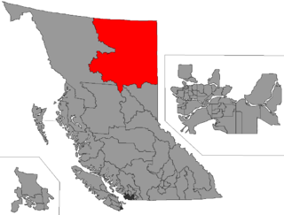
The Northern Rockies Regional Municipality (NRRM), formerly the Northern Rockies Regional District (NRRD), and before that the Fort Nelson–Liard Regional District, is a municipality in northeastern British Columbia, Canada. Although portrayed as a regional municipality in its official name, and existing on the same administrative level as a regional district, it is actually classified as a district municipality. The NRRM's offices are located in Fort Nelson, formerly an incorporated town that amalgamated with the NRRD on February 6, 2009, to form the NRRM. With the Peace River Regional District as the southern part, it was the northern part of the Peace River-Liard Regional District, which was split into two on October 31, 1987.

The Rocky Mountain Trench, also known as the Valley of a Thousand Peaks or simply the Trench, is a large valley on the western side of the northern part of North America's Rocky Mountains. The Trench is both visually and cartographically a striking physiographic feature extending approximately 1,600 km (1,000 mi) from Flathead Lake, Montana, to the Liard River, just south of the British Columbia–Yukon border near Watson Lake, Yukon. The trench bottom is 3–16 km (1.9–9.9 mi) wide and is 600–900 m (2,000–3,000 ft) above sea level. The general orientation of the Trench is an almost straight 150/330° geographic north vector and has become convenient as a visual guide for aviators heading north or south.

The Kechika River is a tributary of the Liard River, about 300 kilometres (190 mi) long, in northern British Columbia, Canada. The Kechika flows generally northwest through the northernmost section of the Rocky Mountain Trench before turning east to join the Liard, a major branch of the Mackenzie River system. The river's 22,700 km2 (8,800 sq mi) drainage basin is characterized by high glaciated peaks, boreal forest, and open tundra. With no settlements, roads or dams along its course, the Kechika is considered "one of British Columbia's finest examples of wilderness and undisturbed wildlife habitat."

The Muskwa River flows 257 kilometres (160 mi) through northern British Columbia, Canada. It is a major tributary of the Fort Nelson River - part of the Mackenzie River system. The river rises at Fern Lake in the Bedaux Pass in the Northern Rocky Mountains. From there, it flows generally east, then north, and then east again to meet with the Fort Nelson River just east of the town of Fort Nelson. The river drops approximately 1,100 metres (3,600 ft), its course taking it down the Rocky Mountain foothills through sub-alpine and boreal forest to meander across the forest and muskegs of the vast Liard River plains. From mouth to headwater, prominent tributaries include the Prophet River, Tuchodi River, and Gathto Creek. Much of the upper portions of this wilderness river and its watershed are located in the Northern Rocky Mountains Provincial Park, which is part of the larger Muskwa-Kechika Management Area. The region is a popular wilderness recreation destination.
Lower Post is an aboriginal community in the Stikine Region of northern British Columbia, Canada, located on Highway 97, the Alaska Highway, approximately 15 miles southeast of Watson Lake, Yukon. Its historical mile designation is Mile 620. It is located near the confluence of the Dease and Liard Rivers.
Liard River is a river in the Yukon Territory, British Columbia and the Northwest Territories, Canada. The Liard River is an officially named Grand Canyon.

The British Columbia Interior, popularly referred to as the BC Interior or simply the Interior, is a geographic region of the Canadian province of British Columbia. While the exact boundaries are variously defined, the British Columbia Interior is generally defined to include the 14 regional districts that do not have coastline along the Pacific Ocean or Salish Sea, and are not part of the Lower Mainland. Other boundaries may exclude parts of or even entire regional districts, or expand the definition to include the regional districts of Fraser Valley, Squamish–Lillooet, and Kitimat–Stikine.
The Sikanni Chief River, is a river in the Northern Rocky Mountains region of the northern interior of British Columbia, Canada. Its headwaters are near Mount McCusker, northeast of the head of the Finlay Arm of Williston Lake. It joins the Fontas River to form the Fort Nelson River southeast of the town of Fort Nelson. However, among the local population the Fontas is viewed only as a tributary of the Sikinni Chief, in the view that the Sikanni continues to exist, flowing northwest to where it meets the larger Muskwa River where the Fort Nelson River is actually formed in the eyes of the indigenous Dene, Cree and European-descendant populations of Fort Nelson First Nation and Fort Nelson.
The Baldonnel Formation is a stratigraphical unit of Carnian age in the Western Canadian Sedimentary Basin.
The Liard Plateau is a plateau in far northern British Columbia, Canada, located between the Smith and Liard Rivers, and extending north into the Yukon.
The Liard Country, sometimes known simply as "the Liard", is the usual name for a region of far northern British Columbia, Canada, generally describing the immediate environs of the Liard River along the Alaska Highway, and west of the line of the Rockies.
The Major Hart River is a river in northern British Columbia, Canada, flowing north-east into the Turnagain River, a tributary of the Kechika, south-west of the community of Liard River.