Zavala County is a county located in the U.S. state of Texas. As of the 2020 census, the population was 11,677. Its county seat is Crystal City. The county was created in 1858 and later organized in 1884. Zavala is named for Lorenzo de Zavala, Mexican politician, signer of the Texas Declaration of Independence, and first vice president of the Republic of Texas.

Val Verde County is a county located on the southern Edwards Plateau in the U.S. state of Texas. The 2020 population is 47,586. Its county seat is Del Rio. The Del Rio micropolitan statistical area includes all of Val Verde County.

Anderson County is a county in the U.S. state of Texas. Located within East Texas, its county seat is Palestine. As of the 2020 United States census, the population of Anderson County was 57,922. Anderson County comprises the Palestine micropolitan statistical area. Anderson County was organized in 1846, and was named after Kenneth Lewis Anderson (1805-1845), the last vice president of the Republic of Texas.

Brazoria is a city in the U.S. state of Texas, in the Houston–The Woodlands–Sugar Land metropolitan area and Brazoria County. As of the 2020 census, the city population was 2,866.
Lancaster is a city in Dallas County, Texas, United States. Its population was 41,275 according to the 2020 census. Founded in 1852 as a frontier post, Lancaster is one of Dallas County's earliest settlements. Today, it is a suburban community located in the Dallas–Fort Worth metroplex, about 15 mi (24 km) south of downtown Dallas.
Sherman is a city in and the county seat of Grayson County, Texas, United States. The city's population in 2020 was 43,645. It is one of the two principal cities in the Sherman–Denison metropolitan statistical area, and is the largest city in the Texoma region of North Texas and southern Oklahoma.

South Houston is a city in the U.S. state of Texas, within Houston–The Woodlands–Sugar Land metropolitan area and Harris County. The population was 16,153 at the 2020 census. It is bordered by the cities of Houston and Pasadena, and geographically located southeast of Houston.

Bridgeport is a city in Wise County, Texas, United States. The population was 5,923 in 2020. In 2009, Bridgeport was named by the Texas Legislature as the Stagecoach Capital of Texas.
Genoa is an area in Houston, Texas, United States located about 15 miles (24 km) southeast of Downtown Houston; it was formerly a distinct unincorporated area in Harris County.
Garden City is an unincorporated community and census-designated place (CDP) in Glasscock County, Texas, United States. It lies near the center of the county, 27 miles (43 km) south of Big Spring. Garden City serves as the Glasscock county seat, and at the 2010 census had a population of 334. The ZIP code is 79739.
The Concho River is a river in the U.S. state of Texas. Concho is Spanish for "shell"; the river was so named due to its abundance of freshwater mussels, such as the Tampico pearly mussel.

The Pearl Brewing Company was an American brewery established in 1883 in downtown San Antonio, Texas, United States. In 1985, Pearl's parent company purchased the Pabst Brewing Company and assumed the Pabst name.

Bushland is an unincorporated community and census-designated place (CDP) in southwestern Potter County, Texas, United States. A small portion of the CDP extends south into Randall County. According to the Handbook of Texas, the community had an estimated population of 130 in 2000. The community is part of the Amarillo, Texas Metropolitan Statistical Area.

The Austin–Round Rock–San Marcos metropolitan statistical area, or Greater Austin, is a five-county metropolitan area in the U.S. state of Texas, as defined by the Office of Management and Budget. The metropolitan area is situated in Central Texas on the western edge of the American South and on the eastern edge of the American Southwest, and borders Greater San Antonio to the south.
Nolan is an unincorporated community in southeastern Nolan County, Texas, United States. It lies along FM 126 southeast of the city of Sweetwater, the county seat of Nolan County. Its elevation is 2,493 feet (760 m), which happens to be the average elevation of the United States. Although Nolan is unincorporated, it has a post office, with the ZIP code of 79537; the ZCTA for ZIP Code 79537 had a population of 94 at the 2000 census.

Double Mountains is the name of a pair of flat-topped buttes located 13 miles (21 km) southwest of Aspermont in Stonewall County, Texas. While the Handbook of Texas gives their elevation as either 2,000 ft (610 m) or 2,400 ft (732 m), United States Geological Survey maps give the elevation of the western mountain as 2,523 ft (769 m) and that of the eastern mountain as between 2,580 and 2,600 ft. Together, the mountains form part of the high ground dividing the watersheds of the Salt Fork and Double Mountain Fork Brazos River.

Waring is an unincorporated community in northwestern Kendall County, Texas, United States. It lies along local roads and the Guadalupe River, northwest of the city of Boerne, the county seat of Kendall County. Its elevation is 1,345 feet (410 m). Although Waring is unincorporated, it has a post office, with the ZIP code of 78074; the ZCTA for ZIP Code 78074 had a population of 59 at the 2000 census. The community is part of the San Antonio Metropolitan Statistical Area.
Oakville is an unincorporated community in northeastern Live Oak County, Texas, United States. It lies along Interstate 37 northeast of the city of George West, the county seat of Live Oak County. Its elevation is 171 feet (52 m). Although Oakville is unincorporated, it has a post office, with the ZIP code of 78060.
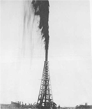
The Texas oil boom, sometimes called the gusher age, was a period of dramatic change and economic growth in the U.S. state of Texas during the early 20th century that began with the discovery of a large petroleum reserve near Beaumont, Texas. The find was unprecedented in its size (worldwide) and ushered in an age of rapid regional development and industrialization that has few parallels in U.S. history. Texas quickly became one of the leading oil-producing states in the U.S., along with Oklahoma and California; soon the nation overtook the Russian Empire as the top producer of petroleum. By 1940 Texas had come to dominate U.S. production. Some historians even define the beginning of the world's Oil Age as the beginning of this era in Texas.
Moffat is a small unincorporated community in Bell County, Texas, United States. It is part of the Killeen–Temple–Fort Hood Metropolitan Statistical Area.