
The River Camel is a river in Cornwall, England. It rises on the edge of Bodmin Moor and with its tributaries its catchment area covers much of North Cornwall. The river flows into the eastern Celtic Sea between Stepper Point and Pentire Point having covered about 30 miles (50 km) making it the second longest river wholly in Cornwall. The river is tidal upstream to Egloshayle and is popular for sailing, birdwatching and fishing. The name Camel comes from the Cornish language for 'the crooked one', a reference to its winding course. Historically the river was divided into three named stretches. Heyl was the name for the estuary up to Egloshayle, the River Allen was the stretch between Egloshayle and Trecarne, whilst the Camel was reserved for the stretch of river between its source and Trecarne.

Kincardineshire or the County of Kincardine, also known as the Mearns, is a historic county, registration county and lieutenancy area on the coast of north-east Scotland. It is bounded by Aberdeenshire on the north, and by Angus on the south-west.

The River Blackwater is a tributary of the Loddon in England and sub-tributary of the Thames. It rises at two springs in Rowhill Nature Reserve between Aldershot, Hampshire and Farnham, Surrey. It curves a course north then west to join the Loddon in Swallowfield civil parish, central Berkshire. Part of the river splits Hampshire from Surrey; a smaller part does so as to Hampshire and Berkshire.

Eye Water is a river in the Scottish Borders, it flows in a general southeasterly direction from its source in the Lammermuir Hills to its estuary at Eyemouth on the east coast of Scotland, having a length of approximately 35 kilometres (22 mi).

Dunglass is a hamlet in East Lothian, Scotland, lying east of the Lammermuir Hills on the North Sea coast, within the parish of Oldhamstocks. It has a 15th-century collegiate church, now in the care of Historic Scotland. Dunglass is the birthplace of Sir James Hall, an 18th-century Scottish geologist and geophysicist. The name Dunglass comes from the Brittonic for "grey-green hill".

The Severn Estuary is the estuary of the River Severn, flowing into the Bristol Channel between South West England and South Wales. Its very high tidal range, approximately 50 feet (15 m), creates valuable intertidal habitats and has led to the area being at the centre of discussions in the UK regarding renewable tidal energy.

Newton's Cove is a small cove, 0.5 kilometres (0.3 mi) south of Weymouth, Dorset, England. Overlooking Portland Harbour, the cove is close to Nothe Gardens and the Nothe Fort.

The Jed Water is a river and a tributary of the River Teviot in the Borders region of Scotland.

The area is popular, mostly in the summer months, with local families, holidaymakers, picnickers, horseriders, ramblers, metal detectors, dogwalkers and the occasional kite buggy. The shallow bay is a popular watersports location for windsurfers, kitesurfers and sea kayaks.

The A1107 is a road in south-east Scotland, in the Scottish Borders. It is a non-trunk route from near Cockburnspath to near Burnmouth.

Cove is a village in the Scottish Borders area of Scotland,18 mi (29 km) northwest of the Scotland/England border. It is about 36 miles southeast of Edinburgh and 8 mi (13 km) from Dunbar. Cove is close to Cockburnspath, Dunglass, Innerwick, Oldhamstocks, Bilsdean, and, further afield, Dunbar and Eyemouth. The climate is typical for Scotland, with cold, wet winters and variable summer weather, with days of rain and days of temperatures over 20 °C (68 °F).

The Ale Water is a tributary of the River Teviot, in the Scottish Borders area of Scotland. It rises at Henwoodie Hill and flows through Alemoor Loch. It meets the Teviot south of the village of Ancrum, and it runs through Ashkirk and Lilliesleaf. At Ancrum the depth of the water is between 0.26 metres (0.85 ft) and 2.24 metres (7.3 ft), although was as deep at 2.88 metres (9.4 ft) on one occasion in 2002.
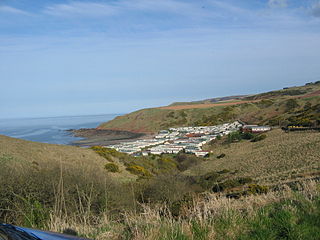
Pease Dean is a nature reserve at Pease Bay, in the Scottish Borders area of Scotland, near the Anglo-Scottish border and Cockburnspath, Cove, and Dunglass. OS 67 NT794707.
Leitholm is a village in the Scottish Borders area of Scotland, 4 miles (6.4 km) north-west of Coldstream, in the former county of Berwickshire.

Yetholm Loch is a loch near Kelso, in the Scottish Borders area of Scotland, in the former Roxburghshire.
Paradise Harbour is a wide embayment behind Lemaire Island and Bryde Island, indenting the west coast of Graham Land, Antarctica, between Duthiers Point and Leniz Point. The name was first applied by whalers operating in the vicinity and was in use by 1920.
The Berwickshire Coastal Path is a walking route some 48 kilometres (30 mi) long. It follows the eastern coastline of Scotland from Cockburnspath in the Scottish Borders to Berwick upon Tweed, just over the border in England. At Cockburnspath the path links with the Southern Upland Way and the John Muir Way.
This article gives an overview of the structure of environmental and cultural conservation in Scotland, a constituent country of the United Kingdom.


