Peck Slip Ferry

Last updated
Map from 1847 showing the route of the Peck Slip Ferry 1847 Lower Manhattan map.jpg
Map from 1847 showing the route of the Peck Slip Ferry

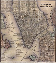
The Peck Slip Ferry was a pre-Brooklyn Bridge ferry route connecting Manhattan and Williamsburg, Brooklyn, New York City, United States, joining Peck Slip (Manhattan) and Broadway (Brooklyn) across the East River.

Contents

History

The Peck Slip Ferry began operations in 1836, supplementing the Grand Street Ferry. [1] The Manhattan ferry port was located along the east side of the former Old Fulton Fish Market building within the South Street Seaport.


See also

Related Research Articles

<span class="mw-page-title-main">South Street Seaport</span> United States historic place

The South Street Seaport is a historic area in the New York City borough of Manhattan, centered where Fulton Street meets the East River, and adjacent to the Financial District, in Lower Manhattan. The Seaport is a designated historic district, and is distinct from the neighboring Financial District. It is part of Manhattan Community Board 1 in Lower Manhattan, and is bounded by the Financial District to the west, southwest, and north; the East River to the southeast; and the Two Bridges neighborhood to the northeast.

<span class="mw-page-title-main">South Ferry (Manhattan)</span>

South Ferry is at the southern tip of Manhattan in New York City and is the embarkation point for ferries to Staten Island and Governors Island. Battery Park, abutting South Ferry on the west, has docking areas for ferries to Liberty Island and Ellis Island. Its name is derived from the more southerly route of service of the historical South Ferry Company in comparison to the Fulton Ferry.

<span class="mw-page-title-main">Dumbo, Brooklyn</span> Neighborhood of Brooklyn in New York City

Dumbo is a neighborhood in the New York City borough of Brooklyn. The area known as Dumbo used to be known as Gairville. It encompasses two sections: one located between the Manhattan and Brooklyn Bridges, which connect Brooklyn to Manhattan across the East River, and another that continues east from the Manhattan Bridge to the Vinegar Hill area. The neighborhood is bounded by Brooklyn Bridge Park to the north, the Brooklyn Bridge to the west, Brooklyn Heights to the south and Vinegar Hill to the east. Dumbo is part of Brooklyn Community Board 2.

<span class="mw-page-title-main">Fulton Ferry, Brooklyn</span> United States historic place

Fulton Ferry is a small area adjacent to Dumbo in the New York City borough of Brooklyn. The neighborhood is named for the Fulton Ferry, a prominent ferry line that crossed the East River between Manhattan and Brooklyn, and is also the name of the ferry slip on the Brooklyn side. The neighborhood is part of Brooklyn Community District 2.

<span class="mw-page-title-main">Fulton Street (Manhattan)</span> Street in Manhattan, New York

Fulton Street is a busy street located in Lower Manhattan in New York City. Located in the Financial District, a few blocks north of Wall Street, it runs from West Street at the site of the World Trade Center to South Street, terminating in front of the South Street Seaport. The westernmost two blocks and the easternmost block are pedestrian streets.

"Crossing Brooklyn Ferry" is a poem by Walt Whitman, and is part of his collection Leaves of Grass. It describes the ferry trip across the East River from Manhattan to Brooklyn at the exact location that was to become the Brooklyn Bridge.

<span class="mw-page-title-main">South Ferry, Brooklyn</span>

South Ferry was a ferry landing on the Brooklyn side of the East River, at the foot of Atlantic Avenue below the Brooklyn Heights neighborhood. It is now Piers 5 and 6 in Brooklyn Bridge Park.

<span class="mw-page-title-main">Grand Street Ferry</span>

The Grand Street Ferry was a ferry route connecting Manhattan and Williamsburg, Brooklyn, New York City, joining Grand Street (Manhattan) and Grand Street (Brooklyn) across the East River.

<span class="mw-page-title-main">Broadway Ferry</span>

Broadway Ferry was a ferry landing in Williamsburg, Brooklyn, New York City, United States at the foot of Broadway. Boats connected it to the Grand Street Ferry, East 23rd Street Ferry, and James Slip landings in Manhattan. In Brooklyn, the Broadway El ended at the ferry.

The Second Avenue Railroad was a street railway company in Manhattan, New York City, United States. Its lines included the Second Avenue Line. The line ran from Peck Slip in Lower Manhattan to the Harlem River. It included branches to the 92nd Street Ferry along the 86th Street Crosstown Line and through 59th Street and First Avenue at the First Avenue Line. Between 1898 and 1908, it was leased by the Metropolitan Street Railway.

The Brooklyn and North River Line, operated by the Brooklyn and North River Railroad, was a trolley line in Manhattan and Brooklyn, New York City, United States. Its route ran from the Desbrosses Street Ferry across Lower Manhattan via the Canal Street Crosstown Line, over a pair of tracks on the east side of the Manhattan Bridge, and to the intersection of Flatbush Avenue and Fulton Street in Downtown Brooklyn. Operation in Manhattan and over the bridge was with conduit electrification, while in Brooklyn it used overhead trolley wire, switching at a plow pit.

<span class="mw-page-title-main">Fulton Ferry (ferry)</span>

The Fulton Ferry was the first steam ferry route connecting Manhattan and Brooklyn, New York City, United States, joining Fulton Street, Manhattan, and Fulton Street, Brooklyn, across the East River. It revolutionized travel between the then City of New York on Manhattan Island and the Village of Brooklyn and the rest of Long Island. Robert Fulton's steam Fulton Ferry Company in 1814 established his name on the ferry service. After the Brooklyn Bridge was built, ridership declined, and the ferry ceased operation on January 19, 1924. NYC Ferry now serves a very similar route.

<span class="mw-page-title-main">Catherine Ferry (East River)</span>

The Catherine Ferry was a ferry route connecting Manhattan and Brooklyn in the United States, joining Catherine Street in Manhattan and Main Street in Brooklyn across the East River.

<span class="mw-page-title-main">Houston Street Ferry</span>

The Houston Street Ferry was a ferry route connecting Manhattan and Williamsburg, Brooklyn, New York City, United States, joining Houston Street (Manhattan) and Grand Street (Brooklyn) across the East River.

<span class="mw-page-title-main">Gouverneur Street Ferry</span>

The Gouverneur Street Ferry was a ferry route connecting Manhattan, New York City, with the city of Brooklyn, by joining Manhattan's Gouverneur Street to Brooklyn's Bridge Street across the East River.

The Roosevelt Street Ferry was a ferry route connecting Manhattan and Williamsburg, Brooklyn, New York City, United States, joining Roosevelt Street (Manhattan) and Broadway (Brooklyn) across the East River.

The Bridge Street Ferry was a ferry route connecting Manhattan and Williamsburg, Brooklyn, New York City, United States, joining James Slip (Manhattan) and Bridge Street (Brooklyn) across the East River.

The James Slip Ferry was a ferry route connecting Lower Manhattan and Long Island City, Queens, New York City, United States, joining James Slip (Manhattan) and Hunter's Point (Queens) across the East River.

The 42nd Street Ferry was a ferry route connecting Manhattan and Williamsburg, Brooklyn, New York City, United States, joining 42nd Street (Manhattan) and Broadway (Brooklyn) across the East River.

<span class="mw-page-title-main">East River Greenway</span> Esplanade in Manhattan, New York

The East River Greenway is an approximately 9.44-mile-long (15.19 km) foreshoreway for walking or cycling on the east side of the island of Manhattan on the East River. It is part of the Manhattan Waterfront Greenway. The largest portions are operated by the New York City Department of Parks and Recreation. It is separated from motor traffic, and many sections also separate pedestrians from cyclists. The greenway is parallel to the Franklin D. Roosevelt East River Drive for a majority of its length.

References

  1. Prime, Nathaniel Scudder (1845). A History of Long Island: from its first settlement by Europeans, to the year 1845. R. Carter. pp. 349–350.