Pedernales, Delta Amacuro

Last updated
Pedernales
Venezuela location map (+claimed).svg
Red pog.svg
Pedernales
Coordinates: 9°57′59″N62°15′09″W / 9.96639°N 62.25250°W / 9.96639; -62.25250 Coordinates: 9°57′59″N62°15′09″W / 9.96639°N 62.25250°W / 9.96639; -62.25250
Country Flag of Venezuela.svg Venezuela
State Delta Amacuro
Municipality Pedernales Municipality
Elevation
15 m (49 ft)
Time zone VST
Climate Am

Pedernales (Spanish pronunciation:  [peðeɾˈnales] ) is a village in the Venezuelan state of Delta Amacuro on the Gulf of Paria. [1] [2]

Venezuela Republic in northern South America

Venezuela, officially the Bolivarian Republic of Venezuela, is a country on the northern coast of South America, consisting of a continental landmass and a large number of small islands and islets in the Caribbean Sea. The capital and largest urban agglomeration is the city of Caracas. It has a territorial extension of 916,445 km2. The continental territory is bordered on the north by the Caribbean Sea and the Atlantic Ocean, on the west by Colombia, Brazil on the south, Trinidad and Tobago to the north-east and on the east by Guyana. With this last country, the Venezuelan government maintains a claim for Guayana Esequiba over an area of 159,542 km2. For its maritime areas, it exercises sovereignty over 71,295 km2 of territorial waters, 22,224 km2 in its contiguous zone, 471,507 km2 of the Caribbean Sea and the Atlantic Ocean under the concept of exclusive economic zone, and 99,889 km2 of continental shelf. This marine area borders those of 13 states. The country has extremely high biodiversity and is ranked seventh in the world's list of nations with the most number of species. There are habitats ranging from the Andes Mountains in the west to the Amazon basin rain-forest in the south via extensive llanos plains, the Caribbean coast and the Orinoco River Delta in the east.

Delta Amacuro State of Venezuela

Delta Amacuro State is one of the 23 states of Venezuela, and is the location of the Orinoco Delta. The Paria Gulf and the Atlantic Ocean are found to the north, Bolívar State is found to the south, the Atlantic Ocean and Guyana are found to the east, and Monagas State is found to the west. The state capital city is Tucupita.

Gulf of Paria A shallow semi-enclosed inland sea between the island of Trinidad and the east coast of Venezuela

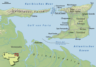
The Gulf of Paria is a 7,800 km2 (3,000 sq mi) shallow semi-enclosed inland sea located between the island of Trinidad and the east coast of Venezuela. It separates the two countries by as little as 15 km at its narrowest and 120 km at its widest points.The tides within the Gulf are semi-diurnal in nature with a range of approximately 1m. The Gulf of Paria is considered to be one of the best natural harbours on the Atlantic coast of the Americas. The jurisdiction of the Gulf of Paria is split between Trinidad and Tobago and Venezuela with Trinidad and Tobago having control over approximately 2,940 km2 (1,140 sq mi)(37.7%) and Venezuela the remainder(62.3%).

Related Research Articles

Colorado River (Texas) river in Texas

The Colorado River is an 862-mile (1,387 km) long river in the U.S. state of Texas. It is the 18th longest river in the United States and the longest river with both its source and its mouth within Texas.

Pedernales River river in the United States of America

The Pedernales River is a tributary of the Colorado River, approximately 106 miles (171 km) long, in central Texas in the United States. It drains an area of the Edwards Plateau, flowing west to east across the Texas Hill Country west of Austin. The name "Pedernales", first used in the middle 18th century, comes from a Spanish word for the flint rocks characteristic of the riverbed.

Pedernales Province Province in Dominican Republic

Pedernales is the southernmost province of the Dominican Republic, including the offshore island of Isla Beata. It was split from Barahona in 1957. Of its 2,074.53 km², 1374 km² belong to the Jaragua National Park.

Point Arguello landform

Point Arguello is a headland on the Pacific coast, in Santa Barbara County, California near the city of Lompoc. The area was first used by the United States Navy in 1959 for the launch of military and sounding rockets. It was transferred to the United States Air Force in 1964, at which time it became part of Vandenberg Air Force Base.

Pedernales may refer to:

Lake Travis Independent School District is a public school district headquartered in unincorporated southwestern Travis County, Texas (USA). It was created on June 12, 1981 after school board members decided to split the Dripping Springs Independent School District in order to handle the growing population of the Lake Travis area.

Pedernales Falls State Park

Pedernales Falls State Park is a state park in central Texas in the United States.

SS Pedernales was a lake tanker of the World War II and post war eras. She was built in 1938 in Monfalcone, Italy, and sailed under the British flag. Pedernales was severely damaged in a torpedo attack on 16 February 1942 while anchored at Aruba.

Cabo Rojo Airport airport in the Dominican Republic

Cabo Rojo Airport is a Caribbean coastal airport in the Dominican Republic 16 kilometres (9.9 mi) southeast of Pedernales, a port city on the border with Haiti. The airport offers domestic flights to destinations within the Dominican Republic.

Lyndon B. Johnson State Park and Historic Site

Lyndon B. Johnson State Park and Historic Site is a state park located along the Pedernales River in Gillespie County, Texas, United States west of Johnson City and east of Fredericksburg. The state created the park with donated land to honor Lyndon B. Johnson as a "national and world leader." The park opened to the public in 1970.

Villagonzalo Pedernales is a municipality located in the province of Burgos, Castile and León, Spain. According to the 2004 census (INE), the municipality has a population of 1,043 inhabitants.

Ranch Road 1 highway in Texas

Ranch Road 1 is a Ranch Road located in Gillespie and Blanco counties, in the central region of the U.S. state of Texas. The highway is approximately 6.6 miles (10.6 km), and begins at U.S. Route 290 in Stonewall, running along the Pedernales River through Lyndon B. Johnson National Historical Park, the late President Lyndon Johnson's former ranch, and through Lyndon B. Johnson State Park and Historic Site, before terminating at US 290 near Hye. The road, designated in 1963, is the only road in the state that TxDOT has designated as a "Ranch Road". In the earliest days of the state highway system, the route was a part of State Highway 20, and was later part of US 290 before that highway was relocated to the south.

Oviedo, Dominican Republic Place in Pedernales, Dominican Republic

Oviedo is a city and municipality in the Pedernales province of the Dominican Republic. It is the southernmost city of the Dominican Republic and of the Hispaniola island.

Pedernales, Dominican Republic Place in Pedernales, Dominican Republic

The Dominican city of Pedernales is the capital of the Pedernales Province, in the Dominican Republic. It is located in the southwest of the country, on the border, and has a crossing to the Haitian town of Anse-à-Pitres.

Pedernales Canton Canton in Manabí Province, Ecuador

Pedernales Canton is a canton of Ecuador, located in the Manabí Province. Its capital is the town of Pedernales. Its population at the 2001 census was 46,876.

Pedernales, Texas Ghost town in Texas, United States

Pedernales, Texas was an early settlement of German immigrants in Gillespie County, and was part of the Adelsverein colonization of Texas. No trace of the settlement remains today. It is located 7 miles (11 km) southwest of Fredericksburg near what is now Texas State Highway 16. The Pedernales school received a Texas Historical Commission Subject Marker in 1993, Marker number 10095.

Blumenthal, Texas Place in Texas, United States

Blumenthal is an unincorporated farming and ranching community on the Pedernales River in Gillespie County, in the U.S. state of Texas. It is located halfway between Fredericksburg and Stonewall on U.S. Highway 290, approximately at the intersection of Jung Lane. The community was believed to have been settled about 1900, and reached its peak population of twenty-five in 1945.

The Pedernales Country Club is a complex located in Lake Travis, 29 miles west of Austin, Texas, United States. Originally the Briarcliff Yacht and Golf Club, a nine-hole golf course constructed in 1968, it was purchased by country music singer-songwriter Willie Nelson in 1979. After the purchase, Nelson constructed a studio on the complex, designed by Chips Moman. The first recording on the studio was Nelson's release Tougher Than Leather and his collaboration with Merle Haggard Pancho and Lefty.

Pedernales Airport airport in Venezuela

Pedernales Airport is an airport serving the village of Pedernales in the Delta Amacuro state of Venezuela.

References