Pele Tower, Angle

Last updated
Pele Tower, Angle
Peles Tower Angle.jpg
Pembrokeshire UK location map.svg
Red pog.svg
Location within Pembrokeshire
General information
Location Angle, Pembrokeshire, Wales
Coordinates 51°41′06″N5°05′18″W / 51.68500°N 5.08833°W / 51.68500; -5.08833

The Pele Tower in Angle, Pembrokeshire, in southwest Wales is a Grade I-listed stone fortified tower dating back to the 14th century and is the only remaining example of a pele tower in Wales. [1] [2]

Angle, Pembrokeshire village in Pembrokeshire, United Kingdom

Angle is a village, parish and community on the southern side of the entrance to the Milford Haven Waterway in Pembrokeshire, Wales. It has a school, two pubs, a village shop with a post office and St Mary's church. There is a bus link to Pembroke railway station.

Wales Country in northwest Europe, part of the United Kingdom

Wales is a country that is part of the United Kingdom and the island of Great Britain. It is bordered by England to the east, the Irish Sea to the north and west, and the Bristol Channel to the south. It had a population in 2011 of 3,063,456 and has a total area of 20,779 km2 (8,023 sq mi). Wales has over 1,680 miles (2,700 km) of coastline and is largely mountainous, with its higher peaks in the north and central areas, including Snowdon, its highest summit. The country lies within the north temperate zone and has a changeable, maritime climate.

Fortified tower defensive structure used in fortifications

A fortified tower is one of the defensive structures used in fortifications, such as castles, along with curtain walls. Castle towers can have a variety of different shapes and fulfil different functions.

Contents

History

The tower has been dated to about the 14th century and appears to have been part of a moated medieval mansion. Until about 1930 the remains of another building of similar dimensions were visible where the northern arm of the moat used to be and where Castle Farm is today. The tower has traditionally been known as the "Old Rectory" and lies within the rectorial glebe of the Parish of Angle. One source suggests that the tower was originally constructed and occupied by the Sherbornes, then Lords of Angle, but this has not been confirmed by other sources. The building was listed with Grade I status on 14 May 1970, as it represented a "very important specimen of mediaeval defensive domestic architecture". [3]

A rector is, in an ecclesiastical sense, a cleric who functions as an administrative leader in some Christian denominations. In contrast, a vicar is also a cleric but functions as an assistant and representative of an administrative leader. The term comes from the Latin for the helmsman of a ship.

Glebe area of land within an ecclesiastical parish used to support a parish priest

Glebe is an area of land within an ecclesiastical parish used to support a parish priest. The land may be owned by the church, or its profits may be reserved to the church.

Listed building Collection of protected architectural creations in the United Kingdom

A listed building, or listed structure, is one that has been placed on one of the four statutory lists maintained by Historic England in England, Historic Environment Scotland in Scotland, Cadw in Wales, and the Northern Ireland Environment Agency in Northern Ireland.

Description

The 9.1-metre-high (30 ft) tower is about 4.5 metres (15 ft) square. [4] It stands on the northern bank of a tidal creek which runs down to the bay; a moat formerly surrounded the site on the other three sides. The upper floors and roof are missing, but the sandstone rubble walls of the tower are nearly complete. On the north side of the tower, the masonry is random rubble, but the other three sides are built in regular courses with a few small stones to align them. The stair turret protrudes about 0.4 metres (1 ft 4 in) on the north and east sides. At the top of the building are two-course corbels on all sides except the turret which suggest a parapet walk with Machicolations. The 1.2-metre-high (3 ft 11 in) doorway is on the east side of the first floor and has a late-medieval segmented arch. Above it in the second storey are two slits that were most likely for the drawbridge chains. Corbels are placed above them to support a hood. [3]

Sandstone A clastic sedimentary rock composed mostly of sand-sized particles

Sandstone is a clastic sedimentary rock composed mainly of sand-sized mineral particles or rock fragments.

Corbel piece of masonry jutting out of a wall to carry any superincumbent weight

In architecture a corbel is in medieval architecture a structural piece of stone, wood or metal jutting from a wall to carry a superincumbent weight, a type of bracket. A corbel is a solid piece of material in the wall, whereas a console is a piece applied to the structure. A piece of timber projecting in the same way was called a "tassel" or a "bragger" in England.

Parapet barrier which is an extension of the wall at the edge of a roof, terrace, balcony, walkway or other structure

A parapet is a barrier which is an extension of the wall at the edge of a roof, terrace, balcony, walkway or other structure. The word comes ultimately from the Italian parapetto. The German equivalent Brüstung has the same meaning. Where extending above a roof, a parapet may simply be the portion of an exterior wall that continues above the edge line of the roof surface, or may be a continuation of a vertical feature beneath the roof such as a fire wall or party wall. Parapets were originally used to defend buildings from military attack, but today they are primarily used as guard rails and to prevent the spread of fires.

Each storey consists of a single room about 3.6 metres (11 ft 10 in) square. The tower has a slightly pointed vaulted basement, which was likely used as a cellar or for storage, [5] a first floor approached by a stair, partly external and partly inside, and a second and third storey accessed through a newel staircase. [6] There are small square windows on the south side facing the creek; all of the other openings are arrow slits. All the floors have fireplaces installed; on the north facing wall for the first and second stories, sharing the same chimney flue inside the wall that ends in a nearly complete chimney. The fireplace for the third storey is on the east wall; all three have stone bressummers. The garderobe is in the east wall of the first storey. [3]

Bressummer

A bressummer, breastsummer, summer beam are load bearing beams in a timber framed building. The word summer derived from sumpter or French sommier, "a pack horse", meaning "bearing great burden or weight". "To support a superincumbent wall", "any beast of burden", and in this way is similar to a wall plate.

Related Research Articles

Doune Castle castle in scotland

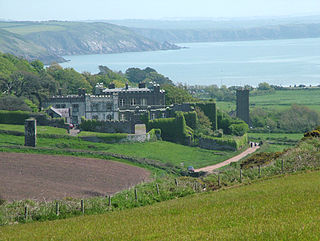
Doune Castle is a medieval stronghold near the village of Doune, in the Stirling district of central Scotland. The castle is sited on a wooded bend where the Ardoch Burn flows into the River Teith. It lies 8 miles (13 km) north-west of Stirling, where the Teith flows into the River Forth. Upstream, 8 miles (13 km) further north-west, the town of Callander lies at the edge of the Trossachs, on the fringe of the Scottish Highlands.

Craigmillar Castle

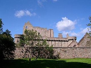
Craigmillar Castle is a ruined medieval castle in Edinburgh, Scotland. It is three miles (4.8 km) south-east of the city centre, on a low hill to the south of the modern suburb of Craigmillar. The Preston family of Craigmillar, the local feudal barons, began building the castle in the late 14th century and building works continued through the 15th and 16th centuries. In 1660 the castle was sold to Sir John Gilmour, Lord President of the Court of Session, who made further alterations. The Gilmours left Craigmillar in the 18th century, and the castle fell into ruin. It is now in the care of Historic Environment Scotland as a scheduled monument.

Audleys Castle

Audley's Castle is a 15th-century castle located 1 mile (1.6 km) north-east of Strangford, County Down, Northern Ireland, on a rocky height overlooking Strangford Lough. It is a three-storey Tower house named after its 16th century owner, John Audley. Audley's Castle tower house and bawn is a State Care Historic Monument in the townland of Castleward, in Down District Council area, at grid ref: J5781 5058.

Carsluith Castle Scotland

Carsluith Castle is a ruined tower house, dating largely to the 16th century. It is located beside Wigtown Bay in the historical county of Kirkcudbrightshire in Galloway, Scotland, around 4.8 kilometres (3.0 mi) south east of Creetown.

Amisfield Tower

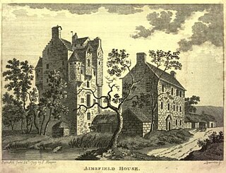
Amisfield Tower is a well-preserved tower house near Tinwald, about 5 miles (8.0 km) north of Dumfries, in Dumfries and Galloway, south-west Scotland. The castle has also been known as Hempisfield Tower. It is a Category A listed building.

Greenknowe Tower tower house near the village of Gordon, in the Scottish Borders

Greenknowe Tower is a 16th-century tower house, located just west of the village of Gordon, in the Scottish Borders. Although a roofless ruin, the stonework of the tower is well preserved, and represents a fine example of a later tower house, built more as a residence rather than as a place of defence. The building is located at NT639428, beside the A6105 road. It is a Scheduled Ancient Monument, and is in the care of Historic Scotland.

Barholm Castle

Barholm Castle is a tower house located five miles south-west of Gatehouse of Fleet, in Kirkcudbrightshire, Galloway, Scotland. The tower dates back to the late 15th century, and it was a stronghold of a branch of the MacCulloch family. The present form of the castle dates from rebuilding in the 16th or 17th century, and in the early 2000s it was restored from a roofless state to residential use. Barholm The tower is sometimes identified with the fictional Ellangowan, in Sir Walter Scott's Guy Mannering.

Tranent Tower

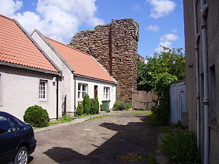
Tranent Tower, is a ruined L-plan tower house dating from the 16th century, in Tranent, East Lothian, Scotland. The remains are protected as a scheduled monument.

Dale Castle Grade II listed building in Pembrokeshire. Situated prominently to W of village, on rising ground facing S

Dale Castle is a 13th-century castle located close to the village of Dale in Pembrokeshire, Wales. In 1910, part of the castle was removed and other parts were incorporated into a new private dwelling house, built in the style of a fortified manor house.

St Leonards Tower, West Malling Grade I listed architectural structure in the United Kingdom

St Leonard's Tower is a probable Norman keep in West Malling, in the county of Kent, England. The tower was probably built by Gundulf, the Bishop of Rochester, between 1077 and 1108. It was a three storey building, constructed of local stone, and would have stood at least 22 metres (72 ft) high. At a later point, probably during the English Civil War, the tower was deliberately damaged to prevent it being used for military purposes, and its uppermost storey was demolished. Concerns grew about the tower's condition in the 20th century and in 1937 it was taken into the guardianship of the state. In the 21st century, it is managed by English Heritage and the exterior is open to visitors.

Barr Castle late medieval tower house in Lochwinnoch, Scotland

Barr Castle is a late medieval tower house. It can be seen today as a ruin on a low ridge to the south of the village of Lochwinnoch, Renfrewshire, Scotland.

Dally Castle Grade I listed castle in the United Kingdom

Dally Castle is a ruined 13th-century stone motte-and-bailey fortress in Northumberland, and one of the first hall houses in Northumberland. It lies 5 miles (8.0 km) west of Bellingham Castle, and 4 miles (6.4 km) west of Bellingham on the Chirdon Burn, a tributary of the North Tyne. Dally Castle House was built in the 18th century next to the castle. Across the road lies a small flour mill used to grind wheat during the Napoleonic War.

Auchanachie Castle, also known as Achanachie Castle or Auchanachy Castle, is a tower house dating from the sixteenth century, 5 miles north-west of Huntly, Aberdeenshire, Scotland.

Fordyce Castle

Fordyce Castle is a T-plan castle, its oldest part dating from 1592, about three miles south west of Portsoy, in the village of Fordyce, Aberdeenshire, Scotland.

Tillycairn Castle is an L-plan castle, dating from the 16th century, standing on high ground around 2.0 miles (3.2 km) south east of Cluny in Aberdeenshire, Scotland.

Ardblair Castle is an L-plan castle, dating from the 16th century, around 0.75 miles (1.21 km) west of Blairgowrie in Perth and Kinross, Scotland.

Tenby town walls Grade I listed building in Pembrokeshire.

The Tenby town walls are Grade I-listed medieval defensive structures around the town of Tenby in Pembrokeshire. They are assessed as one of the most important surviving medieval city walls in Britain. The walls were built in the 13th century by the Earls of Pembroke and improved in the 1450s. They were last known to have been repaired in 1588 and have declined thereafter. Most of the town's gates were demolished beginning in the 18th century and only one survives.

Paterchurch Tower Grade I listed building in Pembrokeshire.

Paterchurch Tower is a Grade I-listed medieval fortified tower in Pembroke Dock, Pembrokeshire, Wales. It received its name from one of the families that owned the land. While its exact function is not known, it probably served as a pele tower for the manorial complex in which it was situated.

Dalcross Castle

Dalcross Castle is a restored 17th century tower house, about 1.5 miles (2.4 km) south west of Croy, Highland, Scotland, about 7 miles (11 km) north and east of Inverness. The castle stands on a ridge.

Earlshall Castle

Earlshall Castle is a restored 16th century courtyard castle, near Leuchars Station about 0.5 miles (0.80 km) east of Leuchars, Fife, Scotland

References

  1. Plant, Steve (2014). A Wander Around the Coast of Wales. FastPrint Publishing. p. 195. ISBN   1780357613.
  2. Hull, Lise (2006). Britain's Medieval Castles. Praeger Publishers. p. 117. ISBN   0275984141.
  3. 1 2 3 "Pele Tower - Angle - Pembrokeshire - Wales". www.britishlistedbuildings.co.uk. British Listed Buildings. Retrieved 30 April 2016.
  4. "Coflein". www.coflein.gov.uk. Retrieved 30 April 2016.
  5. King, D.J.C. (1962). "The Castles of Pembrokeshire". The Archaeological Journal. 119: 313–316.
  6. Edwards, Emily Hewlett (1909). Castles and Strongholds of Pembrokeshire. Tenby: J.E. Arnett, The Library. pp. 39–40.